| home previous page |
NORLEX |  |
| home previous page |
NORLEX | |
Derivatio nominis: The name Grindhval comes from the Norwegian for the small pilot whale Globicephala melas, usually between 4-6m size and found commonly along the northern Norwegian coastline and in the open sea around Greenland and Iceland in the Norwegian Sea.
The sandstones are medium grey to light olive grey, with clear to translucent quartz grains and occasionally pink quartz, very fine to medium grained, occasionally coarse grained, moderate to well sorted, sub-angular to sub-rounded, friable to firm, moderately hard, occasionally very hard, slight to moderate calcareous cement, occasionally very calcareous, micro-pyritic, rarely micaceous and glauconitic, occasionally slightly argillaceous, with fair to good visible porosity in parts.
The mudstones are medium dark grey to dark grey, olive grey to dark green-grey, moderately hard to hard, sub-fissile to sub-blocky, occasionally very fine sandy in parts, micaceous to micro-micaceous, rarely glauconitic, with generally abundant micro-pyrite, slightly to moderately calcareous or occasionally very calcareous, occasionally grade to siltstones.
One or two thin (< 15cm) biorturbated chalk beds maybe developed in the upper part of the member when seen in core.
Reference well 6305/8-1: 10 slides from 4 core pieces and 6 ditch cuttings samples covering the interval 2978.28m core- 3003m dc deposited at the NPD (RRI preparations).
Type well 6305/5-1: core# 4 - core#6 (2771.75mMD RKB û 2816.3mMD RKB). The core covers the entire section with a minor gap between 2783m -2790m.
Reference well 6305/8-1: core # 4 and core #5 (2959.1mMD RKB û 2987.65mMD RKB) covering the majority of the member and the upper boundary with the overlying Tang Formation, Rogaland Group, Tang Formation.
 6305/5-1, 2771-2776 m |
 6305/5-1, 2776-2781 m |
 6305/5-1, 2781-2783 m |
 6305/5-1, 2790-2792 m |
 6305/5-1, 2792-2797 m |
 6305/5-1, 2797-2802 m |
 6305/5-1, 2802-2807 m |
 6305/5-1, 2807-2812 m |
 6305/5-1, 2812-2816 m |
 6305/8-1, 2959-2963 m |
 6305/8-1, 2963-2967 m |
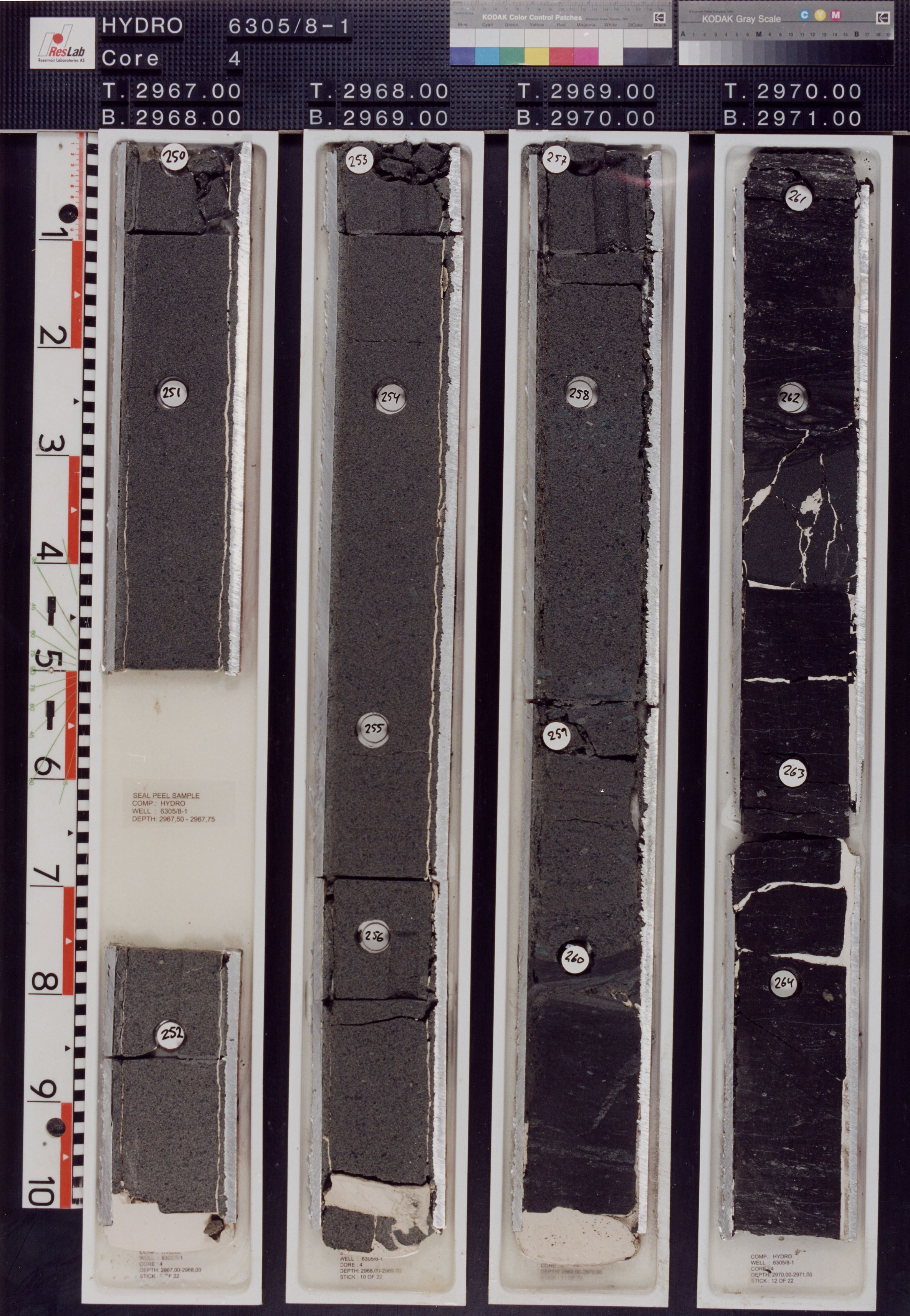 6305/8-1, 2967-2971 m |
 6305/8-1, 2971-2975 m |
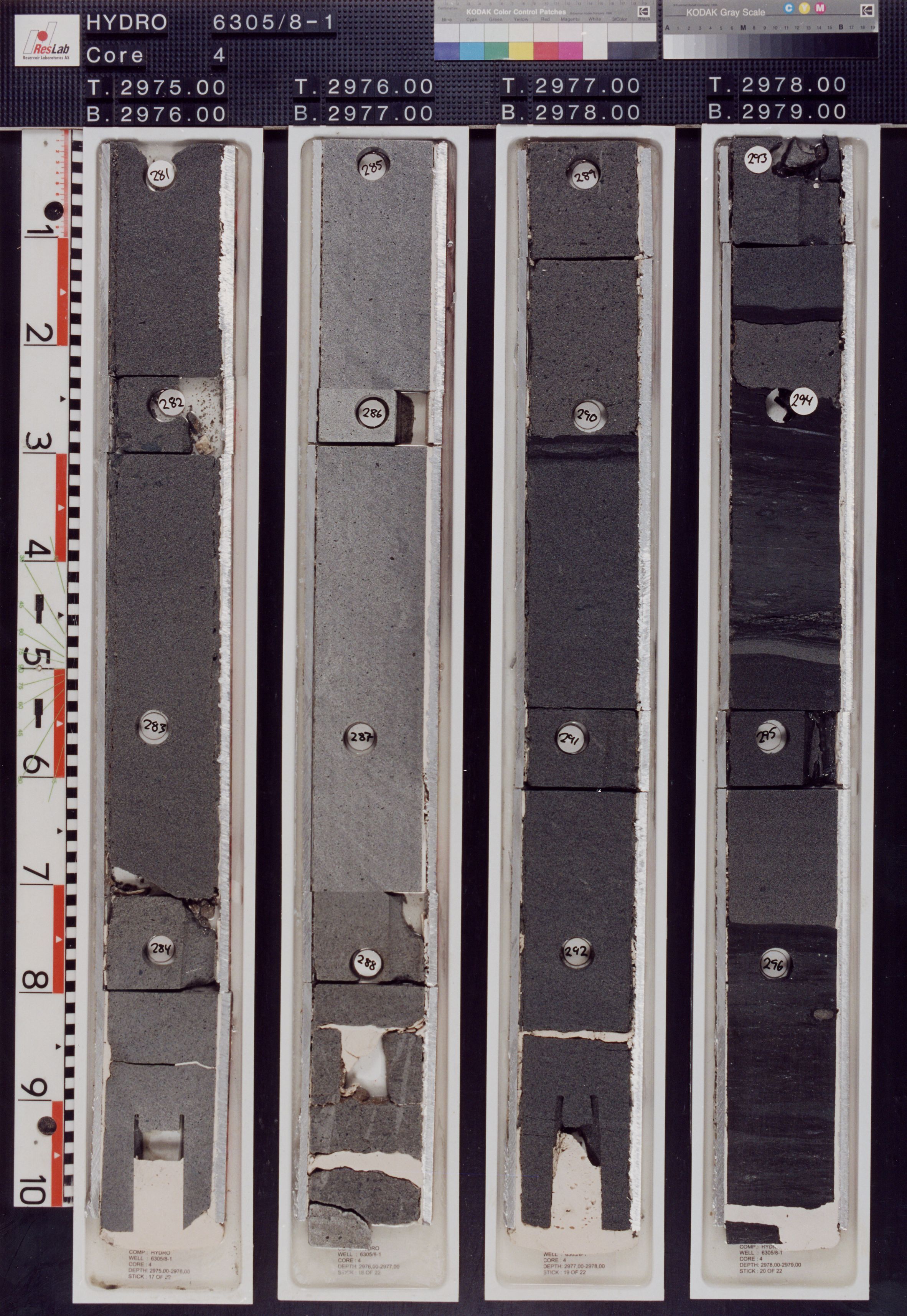 6305/8-1, 2975-2979 m |
 6305/8-1, 2979-2980 m |
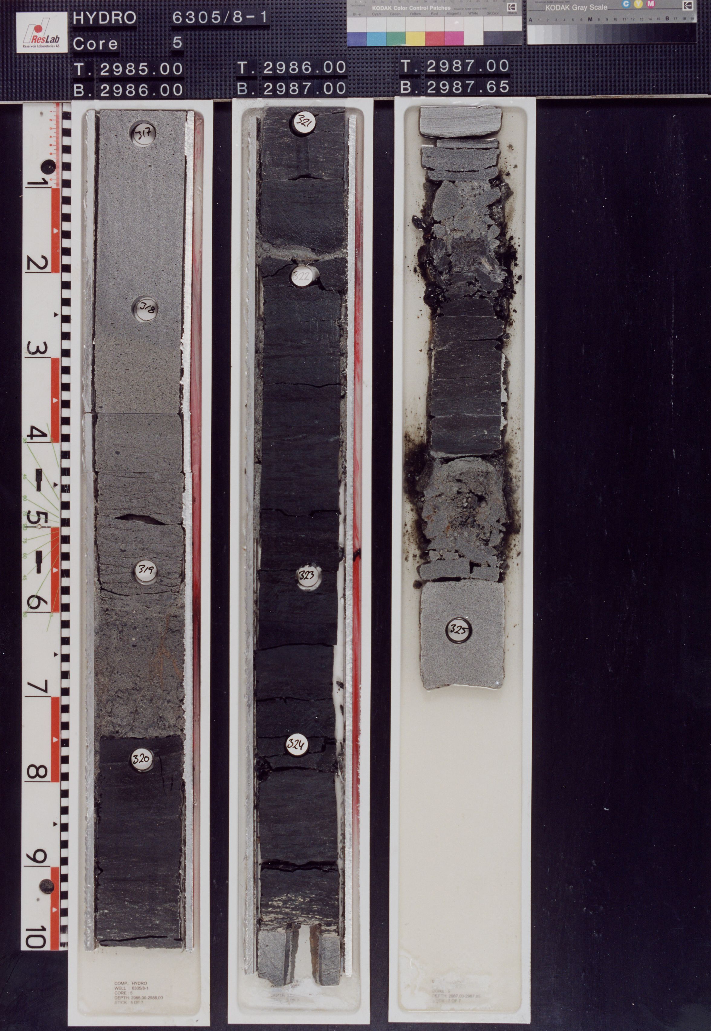 6305/8-1, 2985-2988 m |
Published core description 6305/5-1, by Gjelberg (PDF)
Occurrences of formation tops in wells
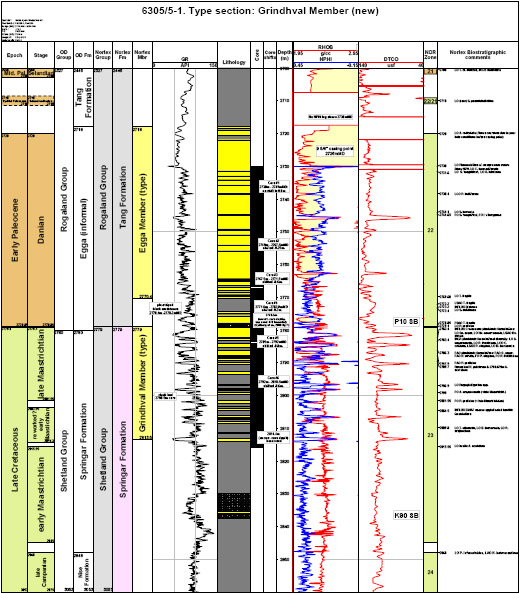
Grindhval Member in type section. Click to enlarge.
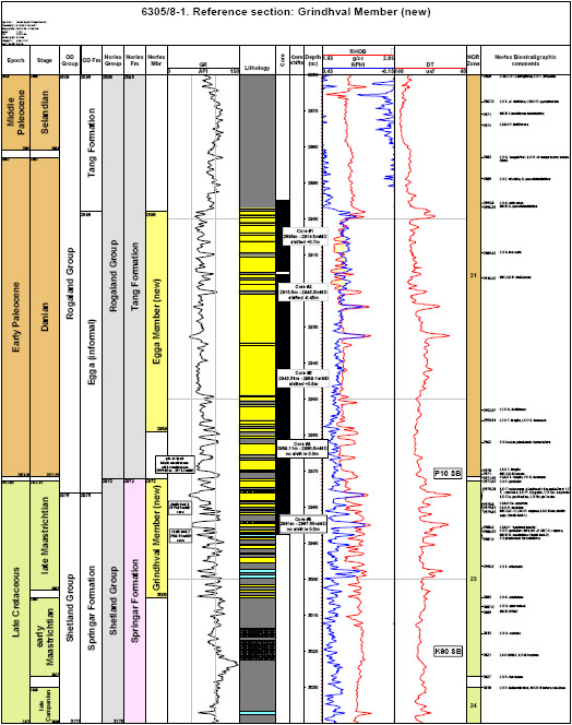
Grindhval Member in reference section. Click to enlarge.
The member is developed below the LO late Maastrichtian planktonic foraminifera: LO Rosita contusa, LO Abathomphalus mayaronsis, LO Racemiguembelina fructicosa, LO Globigerinelloides asperus, LO Heterohelix spp. and dinocyst LO Palynodinium grallator. The base is close to the LO Alterbidium acutulum (early Maastrichtian) and above LO Odontochitina operculata within Zone 23.
The sporadic record of the dinocyst marker Hystrichodinium pulchrum within the lower part of the member in the type well 6305/5-1 is considered to be due to intra-formational reworking from up-slope locations.
With the available data, this member appears to be restricted to the late Maastrichtian with some reworking of early Maastrichtian palynomorphs. The base of the member appears to be close to the early/late Maastrichtian boundary.
Minor un-named sands within the in the Trµna Basin, north of the Tr°ndelags Platform e.g. 6710/10-1 well are time equivalent i.e. late Maastrichtian to the Grindhval Member and suggest either a synchronous tectonic event or general period of lowered sea-level. These sands are also presumably sourced from the Norwegian mainland. They are slightly younger than the Hvithval Member in the V°ring Basin that is interpreted as being sourced from east Greenland.
On a local, field-scale, one or two, thin (<15 cm) chalk beds appear to be correlatable across the Ormen Lange Field where core is available. These are characterised by common planktonic foraminifera Rugoglobigerina rugosa and Globigerinelloides asperus and provide correlative horizons within the upper part of the member.
The change in background sedimentation from green, bioturbated mudstones of the Grindhval Member to black or grey, pin-stripped mudstones of the overlying, lowermost Tang Formation appears to be closely related to the C/T boundary event (see discussion on possible causes in Gjelberg et al., in press) and provides a correlative event at the top of the member.
The core log for well 6305/5-1 illustrated by Gjelberg et al. (1999) and their annotated core photographs are reproduced here. Their facies terminology is also adopted in the following discussion of the depositional setting for the Grindhval Member.
Overall, the Grindhval succession shows a poorly defined, sandier upwards development that is combined with a thickening upwards of individual sandstone beds. In general terms, Gjelberg et al. (2001) interpreted the section in well 6305/5-1 as representing deposition in a mainly outer fan setting on the basin floor of primarly non-channelised lobe deposits under turbiditic processes. The sandstones were sourced into the Ormen Lange sub-basin from the Norwegian mainland via a narrow shelf developed along the eastern margin of the M°re Basin (Gjelberg et al., in press). In the Ormen Lange Field, the thickest sand development is in well 6305/7-1 in the southern region where more than 20m of sand-dominated facies are recorded. Northwards, sandstones decrease and in the 6305/1-1 T2 well sand is absent although the time equivalent isochore increases in thickness. This thickening towards the northwest maybe explained by interfingering of the Ormen Lange system with other fine grained systems derived from the north or west (Gjelberg et al., in press).
In detail, the lower part of the Grindhval Member consists mainly of thin bedded and massive or vaguely laminated sandstones (Facies A û sandy high density turbidites) and graded bedded, fine to medium grained sandstones (Facies B or low density ôclassicalö turbiditesö). These are interbedded with thick beds of green and grey highly bioturbated and calcareous mudstones (Facies D) interpreted to represent mainly fine-grained, sediments deposited from suspension in a relatively deep water column, probably far below storm wave base. The microfaunas of agglutinated foraminfera are indicative of upper bathyal depths. The thick bedded nature of the background mudstones indicates that at the onset of Grindhval deposition, the background sedimentation was more or less uninterrupted for long periods of time between each turbidity current event.
A 13cm bed of bioturbated chalk (Facies F) with Planolites, Zoophycos and possibly Taenidium satanassi trace fossils is present in the middle part of the Grindhval Member in well 6305/5-1 and rests, with a sharp base, on top of a high density turbidite current. In spite of its relative thinness, this chalk and others recognised in well 6305/8-1 are correlatable in other wells on the field where core is available. Gjelberg et al. (2001) interpreted this rare bed as being deposited under suspension in a brief period favourable for the production of coccoliths (and planktonic foraminifera).
According to Gjelberg et al. (2001), the upper part of the Grindhval Member contains more or less the same facies as in the lower part of the succession, with alternating high-density currents (Facies A) and green and dark-grey mudstones (Facies D). The main difference is that the individual turbidites are thicker, are commonly amalgamated and are separated by thinner mudstone intervals between the turbidites. This suggests that the frequency between each individual turbidite event increased.
Towards the top of the Grindhval Member and located at the K/C boundary in well 6305/5-1 (between 2779.65m- 2780m uncorrected core depths) is an atypical, relatively thick, deformed sandstone with contorted bedding and broken sandstone fragments that is commonly associated with sand injection (Facies G).
Overlying the sandstones of the Grindhval Member, at a level just above the K/C boundary is an interval of hemipelagic black and dark grey, non-calcareous mudstones with millimetre- scale thin laminae of silt or fine grained sandstones (Facies E). These æpin-stripped mudstonesÆ, as they have been known, are distinct from the green mudstones developed both above and below this facies and the degree and diversity of bioturbation is generally low (BI 1 to 2) with only rare Planolites traces. This distinct facies and interval separates the Grindhval Member from the overlying Egga Member in the basal part of the Paleocene succession and appears to be a deep water and high latitude expression of the C/T boundary event or some significant change in basin physiography. Irrespective of its depositional origin, this interval provides a distinctive lithological feature to distinguish sandstones of the Cretaceous Grindhval Member from those of the overlying Paleocene Egga Member.
Gjelberg, J., Martinsen, O.J., Charnock, M. A., M÷ller, N.K. and Antonsen, P. (in press). The Reservoir Development of the Early Paleocene Ormen Lange Gas Field, M°re Basin, Mid Norwegian Shelf. Submitted to Journal of the Geological Society of London.
M÷ller, N. K., Gjelberg, J.G., Martinsen, O.J., Charnock, M. A., Fµrseth, R.B, Sperrevik, S. and Cartwright, J. 2004. A geological model for the Ormen Lange hydrocarbon reservoir. Norwegian Journal of Geology, 84, 169-190.
Isaksen, D. and Tonstad, K.1989. A revised Cretaceous and Tertiary lithostratigraphic
nomenclature for the Norwegian North Sea. Bulletin of the Norwegian Petroleum Directorate,
Bulletin No. 5, 1-59.
| home | previous page |