Lista Formation
Rogaland Group
Unit definition
The Lista Formation is attributed to the non marly, bioturbated and poorly laminated greenish
grey claystones and mudstones stratigraphically located between the Vĺle and the Sele
Formations (Fig. 65).
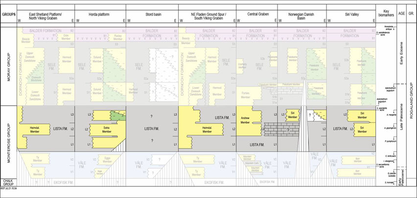
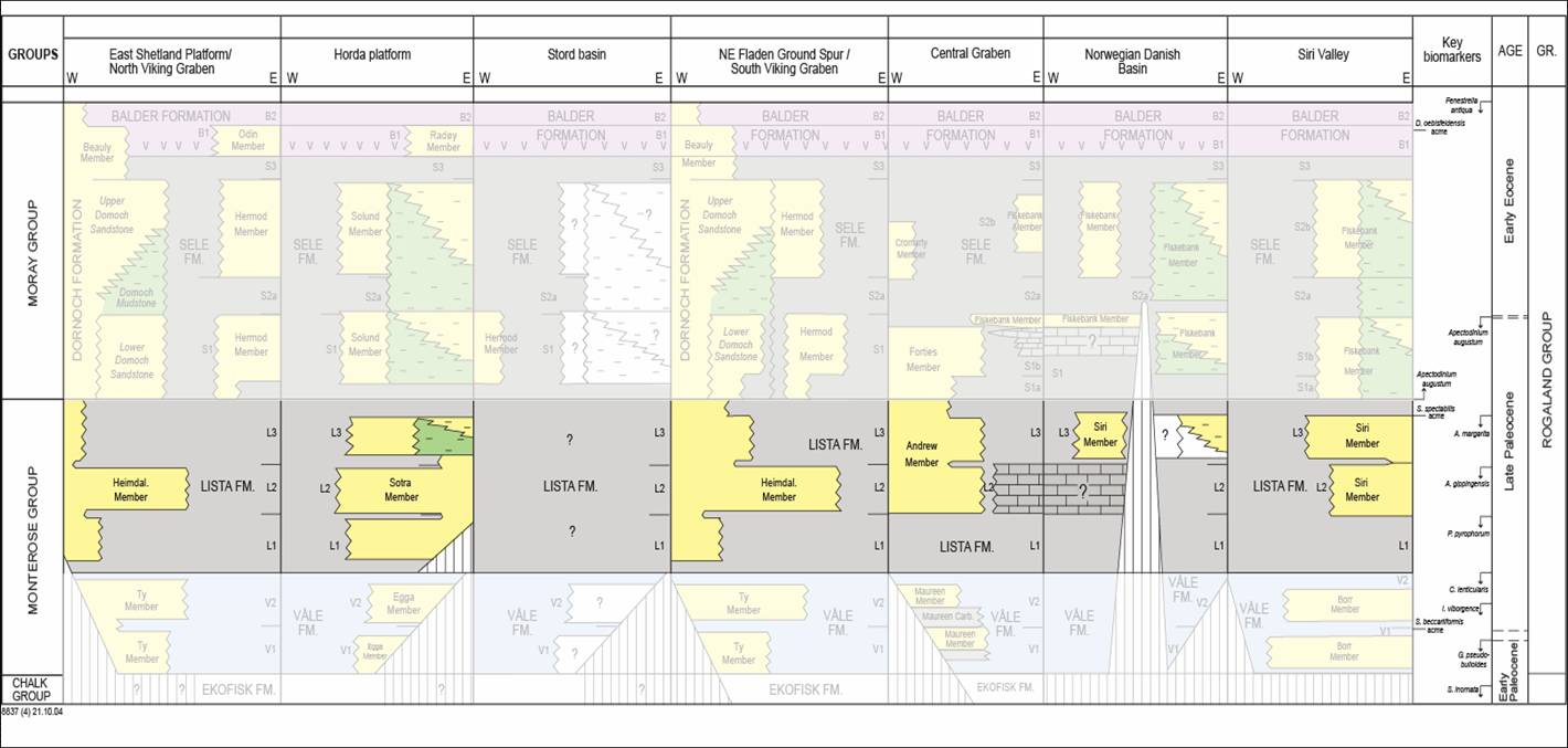
Fig. 65. Lithostratigraphic summary chart of the Lista Formation (color) with members.
|
Name
The Lista Formation was given name by Deegan & Scull (1977).
Derivatio nominis
The formation is named after the Lista district, onshore Norway, and the Lista Spur structure
(Lista Fault Block Complex) in the Norwegian-Danish Basin.
Type well
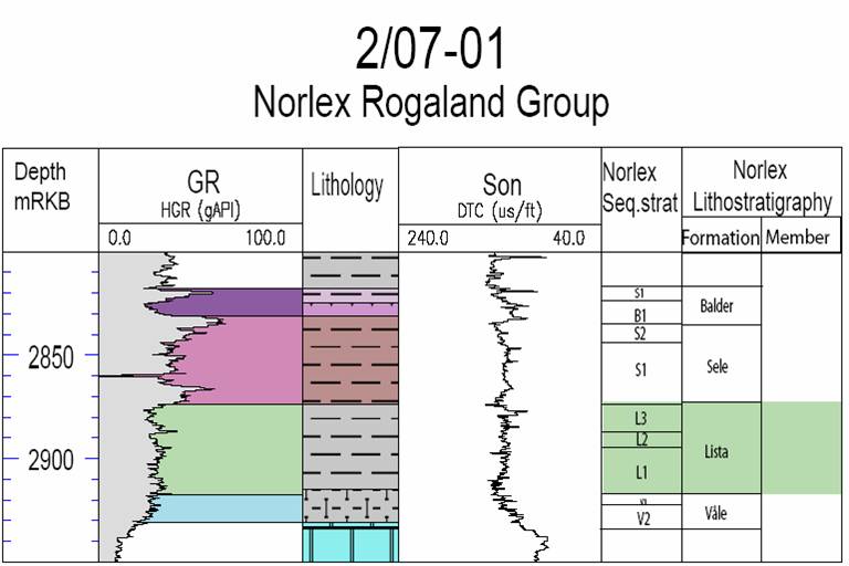
Norwegian well 2/7-1
(Fig. 66). Depth 2918 to 2873 m RKB, coordinates N 56°25'44.68", E 03°12'14.21". No cores.
Defined by Hardt et al. (1989).

Fig. 66. Well 2/7-1. Composite log Rogaland Group. Stratigraphic position of the Lista
Formation is outlined in the stratigraphic column to the right.
|
Reference wells
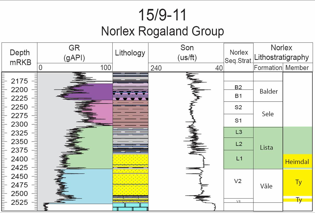
Norwegian well 15/9-11
(Fig. 67). Depth 2386 to 2308 m. Coordinates N 58°24'02.53", E 01°53'41.79". 10 m cores
from the lowest part of the formation. Defined by Hardt et al. (1989).
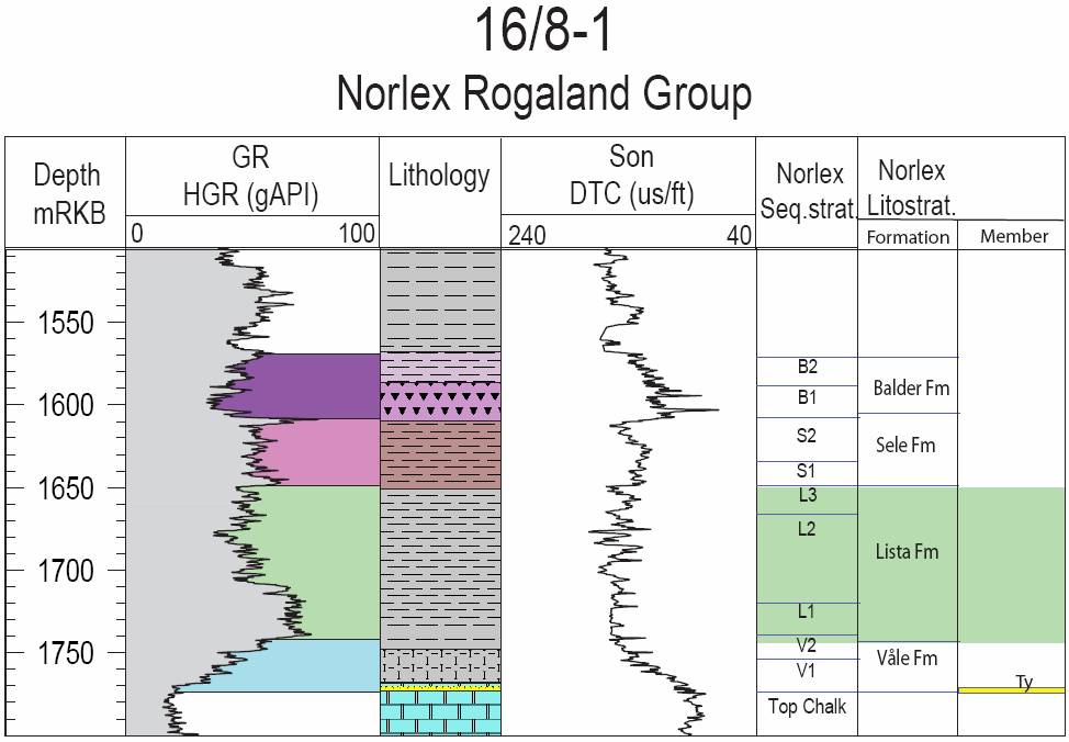
Norwegian well 16/8-1
(Fig. 68). Depth 1749 to 1708 m. Coordinates N 58°27'24.80", E 02°25'56.80". No cores.
Defined by Hardt et al. (1989).
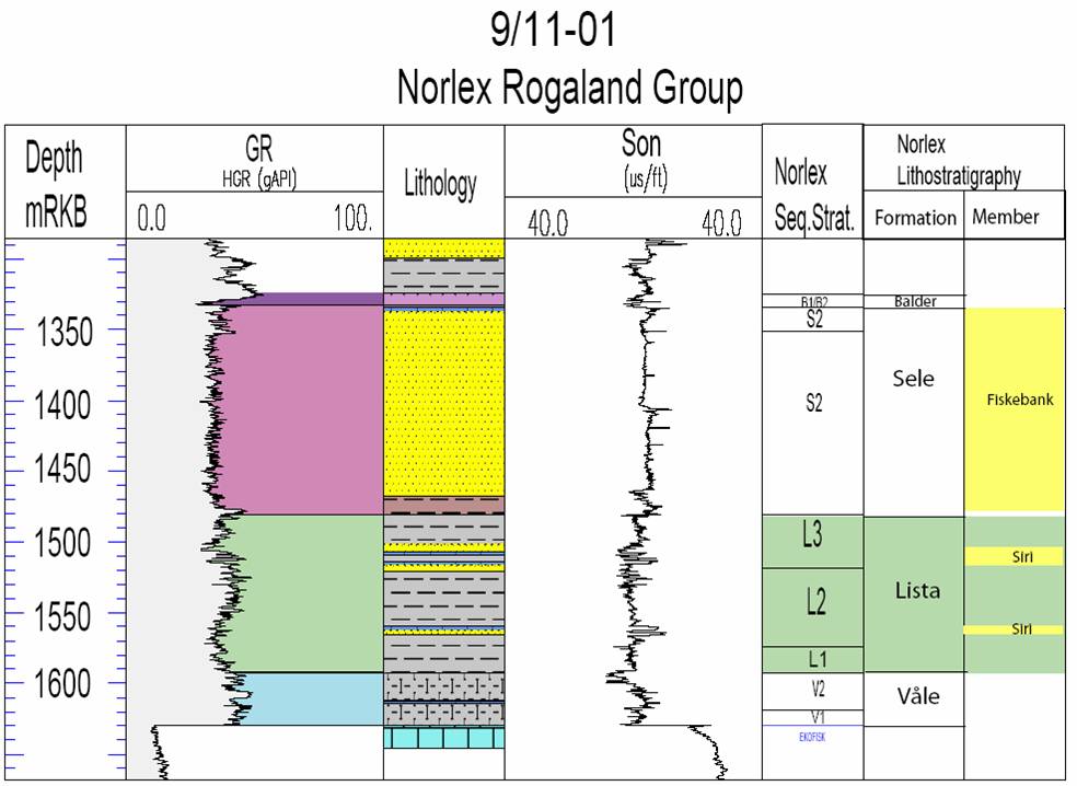
Norwegian well 9/11-1
(New, Fig. 69). Depth 1483-1592 m RKB. Coordinates N 57°00'41.40", E 04°31'40.60. No cores.
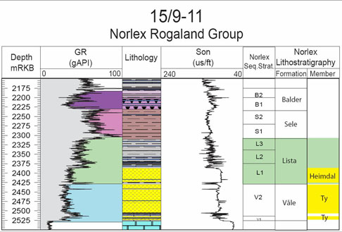
Fig. 67. Well 15/9-11 composite log Rogaland Group. Stratigraphic position of the Lista
Formation is outlined in stratigraphic column to the right.
|
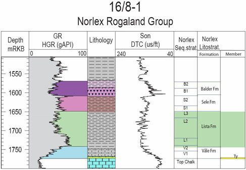
Fig. 68. 16/8-1 composite log Rogaland Group. Stratigraphic position of the Lista Formation
is outlined in stratigraphic column to the right.
|
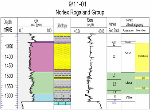
Fig. 69. 9/11-1 composite log Rogaland Group. Stratigraphic position of the Lista Formation
is outlined in stratigraphic column to the right.
|
Composition
The Lista Formation consists of pale green-grey to grey-green shales, with subordinate pale
yellow-grey, red-grey, red-brown and dark grey zones.
The shales are generally non-tuffaceous, non-calcareous, non-carbonaceous, blocky,
bioturbated and poorly laminated. The degree of fissility is directly related to the
intensity of bioturbation (Knox & Holloway, 1992), with the mudstones in middle and upper
parts being totally homogenized. Zoophycos burrows are common.
Occasionally, the Lista Formation contains stringers of limestone, dolomite and pyrite. Thin
argillized, primary air-fall tuff layers are present in the lower parts of the formation
(Knox & Holloway, 1992).
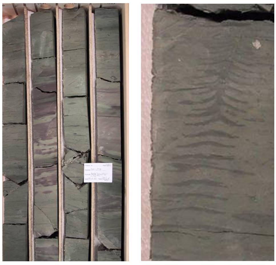
Representative core photo examples of mudstones of the Lista Formation are shown in Fig. 70.

Fig. 70. Core photographies of Lista Formation well 35/10-2. Left: Sediments are composed of
bioturbated green claystone with common purple red patches. Right: Nice example of
Zoophycos burrows in sediments. Photographies by L. Vergara and H. Brunstad.
|
The examples show mudstones of dominantly green grey colour, and with purple red patches. As
can be seen the mudstones have a mottled and poorly laminated look, which can be explained by
heavy bioturbation. Zoophycos (Fig. 70), Chondrites and Planolites are
common trace fossils in the Lista Formation.
Wire line log characterization
The shales of the Lista Formation are generally characterized by intermediate wire line log
readings, but there is considerable variability, and several internal zones with high
gamma-ray readings occur, representing flooding or condensation surfaces. Velocity logs
display spikes of high acoustic velocity that can be related to thin beds or nodules of
carbonate.
Lower boundary
The lower boundary of the Lista Formation is synonymous with top of the
Vĺle Formation. The
boundary is picked at the top of a trend of overall increase in gamma-ray response and
general reduction in velocity. Lithologically the boundary is picked at the top of an
upward decrease of carbonate content in the mudstones.
Upper boundary
The upper boundary of the Lista Formation is usually well defined when the upper parts of
this formation or the lower parts of the overlying Sele Formation are
not sandy. Typically,
the boundary can be seen as an abrupt upwards increase in the gamma-ray response from the
Lista Formation, often with a well defined peak in the lowest part of the Sele Formation.
Lithologically, the boundary can be seen as an abrupt transition from green-grey, bioturbated
mudstones of the Lista Formation into dark grey to black laminated shales with only
occasional bioturbation.
Thickness
The Lista Formation including sandstone members reach thickness of more than 500 m (523 m
in Norwegian well 25/4-1). In the Viking Graben shale thickness of the Lista Formation varies
between 100 and 200 m. The formation generally thins towards the highs where thicknesses are
less than 50 m. When the Lista Formation is thin it usually contains no sandstones.
Isochore map LISTA-VĹLE from well data
Seismic characterization
The base of the Lista Formation is associated with the change from higher density and higher
acoustic velocity of the Vĺle Formation into the lower velocity and lower density Lista
Formation, giving a positive acoustic impedance contrast.
The top of the Lista Formation is commonly associated with a well expressed, extensive
seismic event, where the higher velocity Lista Formation is underlying a low velocity zone in
the lowermost part of the Sele Formation, and thus giving a positive acoustic
impedance contrast.
When sandstones are present in the Lista Formation this is often associated with thickening
as well as semi-continuous, undulating internal reflectors and lense shapes, mounds and
trough infills.
Age
Late Middle to Late Paleocene (Late Selandian to Early Thanetian).
Biostratigraphy
The top of the Lista Formation is assigned to last down-hole occurrence of a dinocyst
assemblage dominated by Apectodinium spp. The body of the formation contains in order from
young to old:
- Top Alisocysta margarita
- Top Areoligera gippingensis
- Top Palaeocystodinium cf. australinum
- Top consistent Palaeoperidinium pyrophorum
- Top ACME Palaeoperidinium pyrophorum
The base of the Lista Formation is slightly below the top ACME Palaeoperidinium
pyrophorum and top Isabelidinium ?viborgense.
In terms of shelly microfossils the top of the formation contains a low diversity
agglutinated foraminiferal assemblage.
The body of the Lista Formation contains the last occurrence (tops) of the following
agglutinated taxa in the shown (most likely) stratigraphic order:
- Rzehakina minima
- Saccamina placenta
- Reticulophragmium paupera
- R. garcilassoi (rare)
- Top diversified and abundant agglutinated foraminifera
- Last common occurrence of Spiroplectammina spectabilis
- Ammoanita ruthvenmurrayi
- Hormosina excelsa
- Labrospira pacifica (rare)
- Cystammina sveni
- Conotrochammina voeringensis (rare)
- Ammoanita ingerlisae (rare)
The base of the Lista Formation agrees with the youngest occurrence of Cenosphaera
lenticularis.
The Lista Formation belongs in the foraminiferal Zone NSR2A - 2B, A. ruthvenmurray - R.
pauperum (Gradstein & Bäckström, 1996), and the dinocyst Zones D3b - D4 in Luterbacher et
al.
(2004). The age is Late Selandian through Thanetian, late Middle through Late Paleocene.
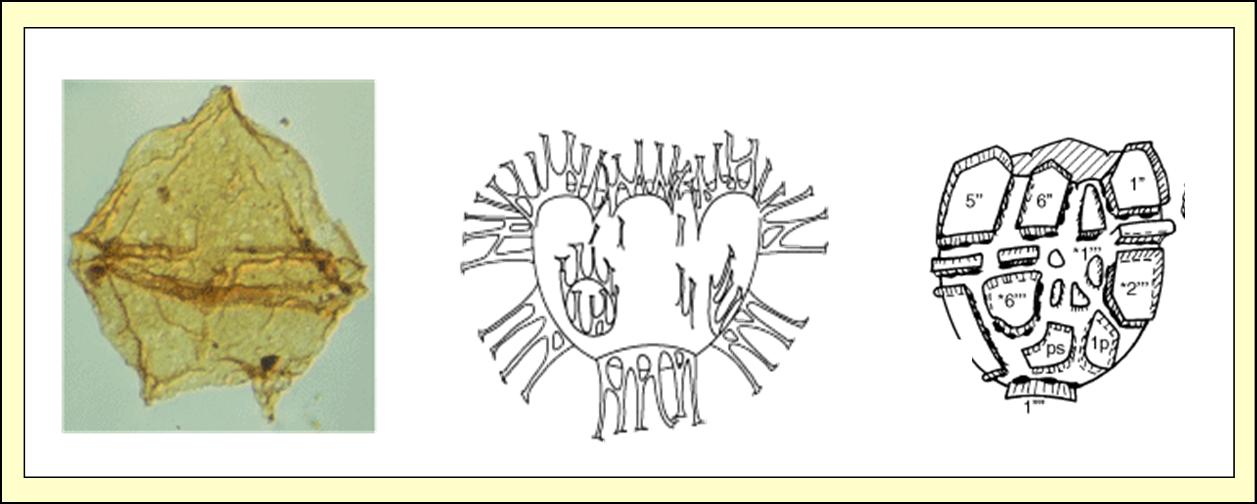
Some diagnostic microfossils of the Lista Formation are shown in Fig. 71.

Fig. 71. Some diagnostic microfossils of the Lista Formation. Palaeoperidinium
pyrophorum
(Ehrenberg 1838 ex O. Wetzel 1933a) Sarjeant 1967b. Dorsal view of dorsal surface; 450x.
Areoligera gippingensis Jolley 1992. Ventral view. Range of type material: overall
length =
32-42 µm, overall width = 45-59 µm, process length = 15-33 µm. Alisocysta margarita
(Harland
1979a) Harland 1979a. Ventral view. Holotype dimensions: length = 44 µm, width = 40 µm. From
the ODP Drilling Program at http://www-odp.tamu.edu.
|
Correlation and subdivision
The Lista Formation can be subdivided into a lower (L1), a middle (L2) and an upper (L3) part
which are separated by condensation surfaces associated with specific bioevents (Knox and
Holloway, 1992). These condensations are associated by high gamma shales and seem to have a
regional importance, and may be related to relative sea level changes (e.g. Mudge and Bujak,
1996).
The base of the L1 zone is picked at the high gamma shale that occurs between the I.
?viborgense
and T. cf. delicata dinocyst zones and close to the top of the Cenosphaera
lenticularis
microfaunal zone. The boundary between the L1 and L2 is taken at the high gamma shales
associated with the P. pyrophorum acme, and the boundary between L2 and L3 is taken at
a high
gamma zone associated with the A. gippingensis acme. The top of the L3 zone is taken
at the high gamma
peak near the base of the Sele Formation, which is associated with the
top of impoverished agglutinated assemblage.
Internally in the Lista Formation several sandstones members are found (Figs. 12 and 13). The
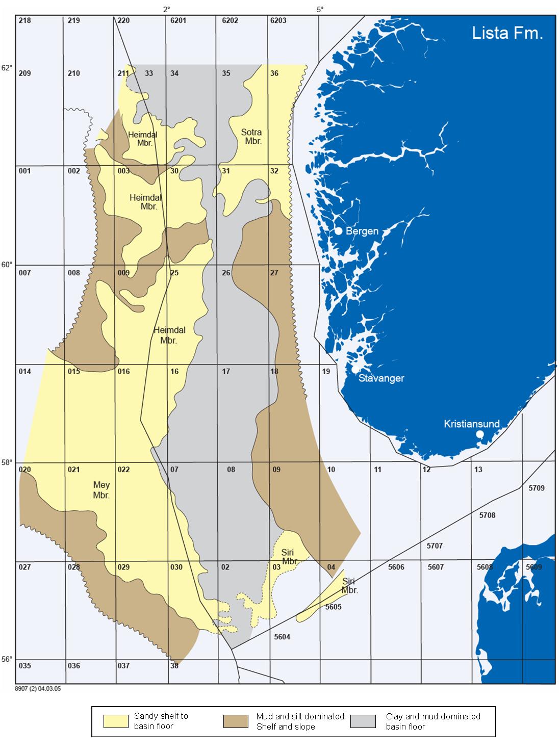
Siri Member and Sotra Member seem to have an eastern provenance (Scandinavia), whereas the
Mey Member and the Heimdal Member have a western provenance (Shetland Platform).
Links to member descriptions
Geographic distribution
The Lista Formation for all practical purposes has a distribution related to the presence of
the Rogaland Group in the Norwegian North Sea. The
Sotra Member is found in the area of Mĺlřy
Platform and Sogn Graben, and may stretch into the Stord Basin (Fig. 72).
Occurrences of formation tops in wells
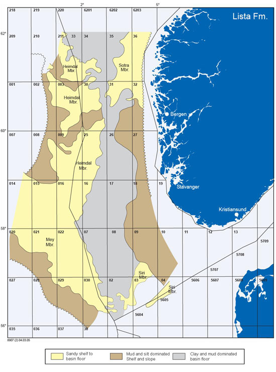
Fig. 72. Distribution of the Lista Formation and its sandstone Members.
|
Depositional environment
Going from the Vĺle Formation and into the Lista Formation climate
became temperate/cooler
and the connection with the warmer Atlantic and Tethys oceans became more limited. This had
an impact on the water temperature in the North Sea basin, which became cooler. As a response
the amount of calcareous plankton became much less.
The Lista Formation was deposited in a marine environment where the earlier calcareous input
from microorganisms, and reworking from exposed chalk of the Shetland
Group had come to an
end. Accordingly the fines deposited in the basin were dominated by siliciclastic minerals.
The trace fossils in the sediments in general became smaller and sediments darker, reflecting
a less well oxygenated basin in this period.
In the basinal areas of the Viking Graben, Stord Basin and the Central Graben paleo
waterdepth was mostly deep marine, bathyal. To the east paleo waterdepth was shallower,
extending into upper continental shelf slope or shelf setting. Changes between faint dark
purple red and medium grey to dark green colored bioturbated mudstones probably reflect
changes in the balance between water circulation and sedimentation rate. The change between
rich and abundant bioturbation in the mudstones reflects change from rather oxygen rich and
well circulated bottom waters to dysoxic or sometimes anoxic conditions. The silty fraction
increases towards the slope wedges flanking the basin to the east and west (UK).