Spekkhogger Member [new]
Shetland Group,
Nise Formation
Introduction
The Spekkhogger Member is a new member of the Nise Formation and forms a thick (over
800m), sandstone dominated succession of mainly Late Cretaceous, early Campanian age
developed in the V¯ring Basin.
The Spekkhogger Member together with the underlying Tumler Member were targeted by the
first exploration well to be drilled in the deep water V¯ring Basin, the Nyk High well
6707/10-1 (Kittilsen et al., 1999). Excellent quality sandstone reservoirs were recovered that
collectively represented over 1000m thickness and a 156m thick column of dry thermogenic
gas.
The input of large volumes of clastic sediments are considered to have been derived from
sources to the north or north-west, towards Greenland based on heavy mineral analysis or
possibly from the north-east and are linked to the initial phase of Campanian-Paleocene
rifting between the north Atlantic region and the Norwegian Sea.
Name
English/ Norwegian and any previous names:
In the type well 6707/10-1 the Spekkhogger Member was originally and correctly identified
by the operator BP Norway as a sandstone unit within the Nise Formation. It is equivalent in
part (together with the Tumler Member) to the informal ëUtgard sandstoneí of Swiecicki et al.
(1998) and the upper part (only) of the informal Delfin Formation on the fact pages of the
NPD.
Derivatio nominis:
Spekkhogger is the Norwegian name for the killer whale species Orcinus orca. This is
appropriately the largest species of the oceanic dolphin family (Delphinidae) reaching up to
9m in length and 6-8 metric tons in weight. The species is widespread in the North Atlantic
and can been seen along the Norwegian coast. The most famous individual being, of course,
Keiko whose final home was in the bays off Halsa in M¯re and Romsdal.
Lithology
The Spekkhogger Member consists of thick sandstones with subordinate mudstone interbeds
and rare dolomitic limestone stringers.
The sandstones are light to medium grey, light olive grey, brownish grey and pale yellow
brown, transparent to translucent quartz grains, locally colourless to pale grey, rarely pale
orange, very fine to medium, predominantly fine to medium, locally coarse, sub-angular to
sub-rounded, occasionally sub-elongate to sub-sphaerical, moderate to well sorted, generally
loose, occasionally firm, friable, weak silica or dolomitic/calcareous cement, locally
argillaceous matrix, occasional kaolinitic matrix, silty, micaceous, occasionally disseminated
pyrite, common to abundant glauconite, fine carbonaceous material, fair to good visible
porosity.
The mudstones are medium light grey to dark olive grey, with occasional black streaks and
speckles, soft to firm, amorphous to sub-blocky, plastic to crumbly, slightly silty in places or
fine sand, trace disseminated pyrite, micro-carbonaceous, micro-micaceous, occasionally
glauconitic, non-calcareous or slightly dolomitic in part.
The rare dolomitic limestone stringers are buff to off white or light grey-light yellow, soft
to
firm, occasionally hard to very hard, sub-blocky to blocky, crumbly to angular, occasionally
glauconitic, occasionally grading to sandy limestones, microcrystalline.
Sample depository
Palynological preparations (organic matter depository)
Type well 6710/10-1: 44 slides from core samples covering the interval 2978.7m ñ 3145.54
available at the NPD (OD preparations).
Reference well 6704/12-1: 5 slides from sidewall core samples covering the interval 3698m ñ
3904m available at the NPD (RRI preparations).
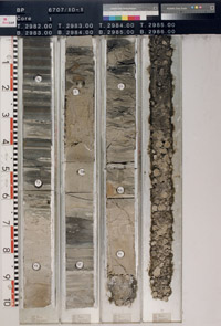
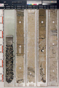
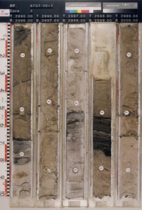
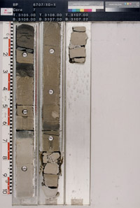
Core photographs
During the drilling of the Nyk High 6707/10-1 gas discovery well, 10 cores totally 206m
thickness were cut with excellent recovery (Kittilsen et al.,1999). With the exception of
core#10 that was cut in the underlying Tumler member (new), all these cores were cut in the
upper part of the Spekkhogger Member or 10m in the overlying mudstones of the surrounding
Nise Formation.
Type well 6707/10-1: core#1 to core #9: 2967mMD RKB ñ 3145mMD RKB
Reference well 6704/12-1: no core taken in this member.

6707/10-1, 2967-2972 m
|
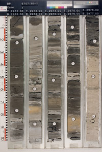
6707/10-1, 2972-2977 m
|

6707/10-1, 2977-2982 m
|
6707/10-1, 2982-2986 m
|
6707/10-1, 2985-2990 m
|

6707/10-1, 2990-2995 m
|
6707/10-1, 2995-3000 m
|

6707/10-1, 3000-3005 m
|
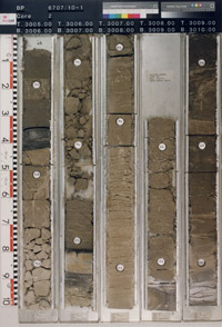
6707/10-1, 3005-3010 m
|
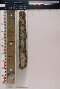
6707/10-1, 3010-3012 m
|

6707/10-1, 3012-3017 m
|

6707/10-1, 3017-3022 m
|
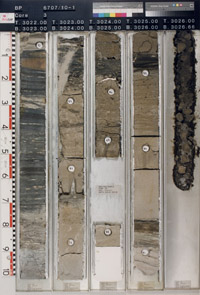
6707/10-1, 3022-3027 m
|
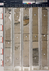
6707/10-1, 3030-3035 m
|

6707/10-1, 3035-3040 m
|
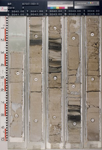
6707/10-1, 3040-3045 m
|
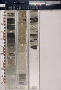
6707/10-1, 3045-3048 m
|
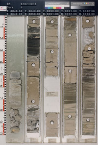
6707/10-1, 3048-3053 m
|
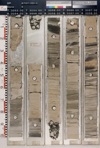
6707/10-1, 3053-3058 m
|

6707/10-1, 3058-3063 m
|

6707/10-1, 3063-3065 m
|
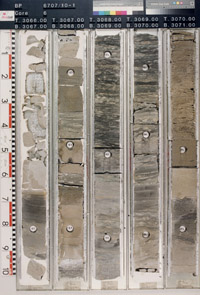
6707/10-1, 3066-3071 m
|
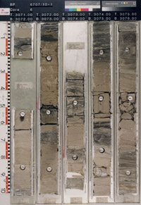
6707/10-1, 3071-3076 m
|
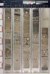
6707/10-1, 3076-3081 m
|

6707/10-1, 3081-3083 m
|
6707/10-1, 3085-3090 m
|
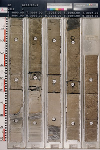
6707/10-1, 3090-3095 m
|
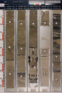
6707/10-1, 3095-3100 m
|
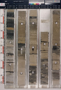
6707/10-1, 3100-3105 m
|
6707/10-1, 3105-3107 m
|
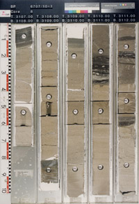
6707/10-1, 3107-3112 m
|

6707/10-1, 3112-3117 m
|

6707/10-1, 3117-3122 m
|
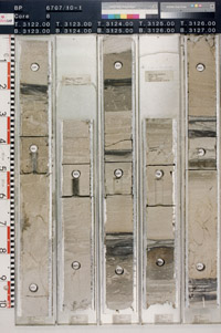
6707/10-1, 3122-3127 m
|
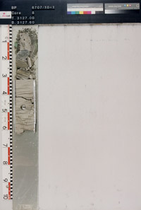
6707/10-1, 3127-3128 m
|
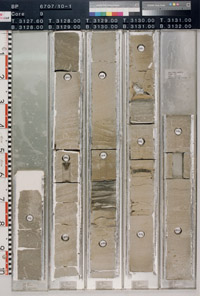
6707/10-1, 3127-3132 m
|
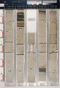
6707/10-1, 3132-3137 m
|
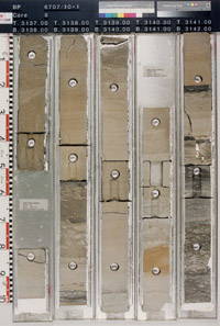
6707/10-1, 3137-3142 m
|

6707/10-1, 3142-3147 m
|
|
Thickness
The Spekkhogger Member varies in thickness from 140m e.g. 6607/5-2 to 833m e.g.
6707/10-1 based on released well data.
Isochore map SPEKKHOGGER
Geographical distribution
[Map]
Sandstones of the Campanian Spekkhogger Member are geographically restricted to the
V¯ring Basin based on released well data with a depositional centre axis close to the Nyk
High well 6707/10-1 where it attains an enormous 833m thickness. The Spekkhogger Member
decreases significantly in thickness both to the west e.g. 6704/12-1 (321.5m) and south-east
e.g. 6607/5-2 (140m) of the Nyk High well 6707/10-1, away from the main depositional
fairway.
Vergara et al. (2001) inferred that sandstones in their equivalent K85 -K90 sequence covered
a large area of the (northern) V¯ring Basin based on seismic interpretation and favoured a
source from the north and north-east although Morton and Grant (1988) had earlier proposed
a source from the north or north-west based on provenance studies on sandstones from the
Utgard High well.
Time equivalent mudstones of the Nise Formation are developed in well 6605/8-1 and define
a southerly limit of the member based on the available well coverage.
The apparent two-fold division of the Spekkhogger Member in the 6607/5-2 maybe due to
sand injection since it is associated with a volcanic intrusion although this is not proven and
requires further work.
Occurrences of formation tops in wells
Type well
Well name: 6707/10-1
WGS84 coordinates: N 67∞04'07.85, E 07∞00'36.51 (figure 2)
UTM coordinates: 7440629.70 N 413490.42 E
UTM zone: 32
Drilling operator name: BP Norway Ltd.
Completion date: 23.07.1997
Status: P & A
Interval of type section (m) & thickness in type well (m):
3810m - 2977m (2977.4m core depth) and 833m thickness.
Reference well
Well name: 6704/12-1
WGS84 coordinates: N 67∞07'25.00, E 04∞42'44.70 (figure 2)
UTM coordinates: 7446374.14 N 574282.36 E
UTM zone: 31
Drilling operator name: Saga Petroleum
Completion date: 24.07.1999
Status: P & A
Interval of reference section (m) & thickness in reference well (m):
3968m - 3646.5m and 321.5m thickness.
Upper and lower boundaries
Upper Boundary
In the type well 6707/10-1, the top of the Spekkhogger Member is defined in core #1 at
2977.4m (uncorrected depth) at the top of the sandstone-rich section. This is associated with a
sharp downward decrease in both gamma-ray and sonic velocity values at 2977mMD. This
does not coincide with the top of the first thin sandstone bed which occurs higher in the
section at 2957mMD within a predominantly mudstone interval.
Lower Boundary
The base of the Spekkhogger Member is well defined on logs and marked by downward
change from sandstones to mudstones. On wireline logs it coincides to a down section
increase in gamma-ray and decrease in sonic log values. In the type well 6707/10-1, the base
is marked by a downward positive separation in neutron and density logs.
Well log characteristics
[Figure]
In the type well 6707/10-1, the thick and sandstone dominated Spekkhogger Member is
characterised by a series of serrated, blocky or funnel-shaped gamma-ray log profiles that
reflect a series of thickening and sandier upward cycles. In the lower part of the cored interval
(cores #6 to 9), there are a series of cycles where the sandstone beds become progressively
thinner upwards but these trends are generally not distinguishable on gamma-ray logs due to
the frequency of glauconite. Overall there is little variation throughout the interval of the
member. Thick mudstone dominated intervals are generally infrequent. There is a relatively
abrupt decrease in average sonic velocities and density values within the upper part of the
member above 3130mMD RKB. Density values are also generally more irregular above this
depth.
Type seismic section
Biostratigraphy
[Figure]
The upper boundary of the Spekkhogger Member lies below the LO Callaiosphaeridium
asymmetricum (mid. Campanian) within Zone 23
The early Campanian dinocyst marker LCO Trithyrodinium suspectum is developed with the
upper part of the member. The upper boundary in the type well is associated with a down-
section increase in pyritised diatoms, notably LO Fenestrella bellii regionally typical of an
early ñ mid. Campanian age.
The base of the Spekkhogger Member lies close, but generally below the dinoflagellate cyst
LO Spongodinium ëcristatumí (earliest Campanian ñ latest Santonian age) and above the LO
Valensiella reticulata (late Santonian). Planktonic foraminifera are typically absent
throughout this member but in the underlying mudstone (developed between the Tumler and
Spekkhogger Members) are the rare LO Whiteinella baltica (Santonian), an increase in
calcareous benthonic foraminifera with Gavelinella - Eponides spp. and diatoms that
forms a regional correlative marker.
Age
Late Cretaceous, early ñ middle Campanian (Zone 23)
The lower boundary of the Spekkhogger Member (and Nise Formation) appears to be close to
the Santonian/Campanian boundary.
The Spekkhogger Member is predominantly early Campanian age. This age interpretation is
consistent with the original interpretation of the type well 6707/10-1 published by Kittilsen et
al. (1999).
Correlation
Sandstones of the Spekkhogger Member pass laterally into mudstones of the
Nise Formation.
The member is part of the K85- K90 sequences of Vergara et al. (2001), K70 sequence of
FÊrseth and Lien (2002) and Lien (2005) and the K80 sequence of Fugelli and Olsen (2005a)
and represents the main input of clastic sediments into the V¯ring Basin during the initial
phases of the Campanian- Paleocene rift episode associated with the continental separation of
the North Atlantic region and the Norwegian Sea (FÊrseth and Lien, 2002) and the
development of the ëCretaceous seawayí between the Norway and Greenland (Gradstein et al.
1999).
Correlation chart for the Spekkhogger Member (PDF)
Depositional environment
The upper part of the Spekkhogger Member is extensively cored in the type well 6707/10-1
well. Kittilsen et al. (1999) has been described this as being predominantly composed of a
trendless stack of poorly amalgamated, metre scale, clean, fine grained sandstone beds that
commonly show fining upward cycles. They interpreted these as the deposits of mainly
episodic, high density turbidity currents within a large scale submarine fan complex. In
addition, there are classical, thinly bedded turbidites with Bouma-type sequences (Ta-c) with
ripple laminated intervals in the upper part.
They noted that many of the turbidite beds pass upwards into ìclay-prone, mud clast-rich
capsî often associated with an increase in carbonaceous material and interpreted these as
linked debris flows which evolved from the tails of the turbidite flows. The debris flows are
overlain by sand laminated mudstones and bioturbated background mudstones of both
turbiditic or hemipelagic origin. These background mudstones contain microfaunas of deep
water agglutinated foraminifera (DWAF) that suggests a bathyal environment with sub-oxic
bottom conditions well below wave base. Kittilsen et al. (1999) observed that there was little
evidence of erosion of the turbidite sandstones into the background mudstones suggesting the
turbidite flows were largely unconstrained in this part of the submarine fan and predicted
them to occur as laterally extensive sheet sands.
On a more regional scale, Vergara et al. (2001) described the geometry and distribution of
these sandstones within their sequences K85-K90. They inferred from seismic that large areas
of the V¯ring Basin were covered by turbidites sourced from multiple entry points. They
indicated that the sandstones in well 6707/10-1 were close to the main depositional centre or
fairway and favoured a source from the north or towards the northeast, in contrast to Morton
and Grant (1998), who, in an earlier provenance study, described the sandstones from the
Utgard High well as ëK2 type sandstonesí with a provenance from the north or northwest.
Remarks
References
Fugelli, E. and Olsen T. R. 2005a. Screening for deep-marine reservoirs in frontier basins:
Part 1 ñ Examples from offshore mid Norway. AAPG Bulletin, 89(7), 853-882.
FÊrseth, R. and Lien, T. 2002 Cretaceous evolution in the Norwegian Sea ñ a period
characterized by tectonic quiescence. Marine and Petroleum Geology, 19, 1005 ñ1027.
Gradstein, F., Kaminski, M.A. and Agterberg, F.P. 1999. Biostratigraphy and
paleoceanography of the Cretaceous seaway between Norway and Greenland. Earth-Science
Reviews, 46, 27-98.
Kittilsen, J. E., Olsen, R.R., Marten, R. F., Hansen, E.K. and Hollingworth, R.R. 1999. The
first deepwater well in Norway and its implications for the Upper Cretaceous Play, V¯ring
Basin. In: Fleet, A.J. and Boldy, S.A.R. (eds) Petroleum Geology of Northwest Europe:
Proceedings of the 5th Conference, Petroleum Geology 1986 Ltd. Geological Society, London,
1, 275- 280.
Lien, T. 2005. From Rifting to drifting: effects on the development of deep-water
hydrocarbon reservoirs in a passive margin setting, Norwegian Sea. Norwegian Journal of
Geology, 85 319-332.
Morton, A.C. and Grant, S. 1988. Cretaceous depositional systems in the Norwegian Sea;
heavy mineral constraints. AAPG Bulletin, 82(2), 274-290.
Swiecicki, T., Gibbs, P.B., Farrow, G.E. and Coward, M.P. 1998. A tectonostratigraphic
framework for the Mid-Norway region. Marine and Petroleum Geology, 15, 245-276.
Vergara, L., Wreglesworth, I., Trayfoot, M., Richardsen, G. 2001. The distribution of
Cretaceous and Paleocene deep-water reservoirs in the Norwegian Sea basins. Petroleum
Geoscience, 7, 395-408.


