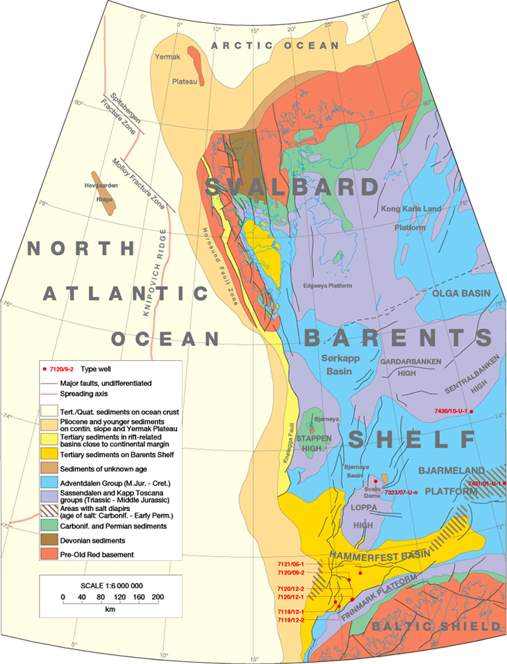
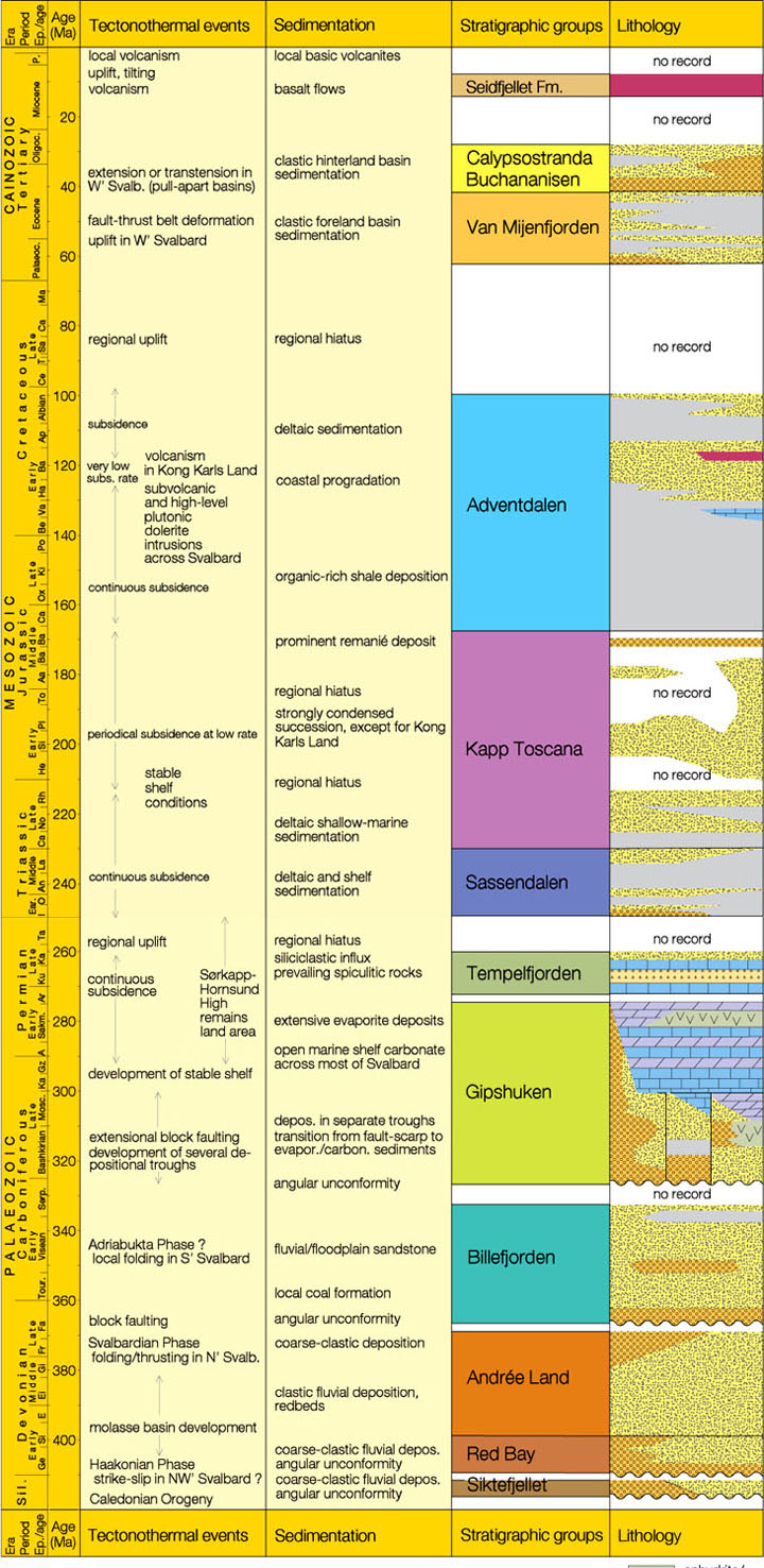
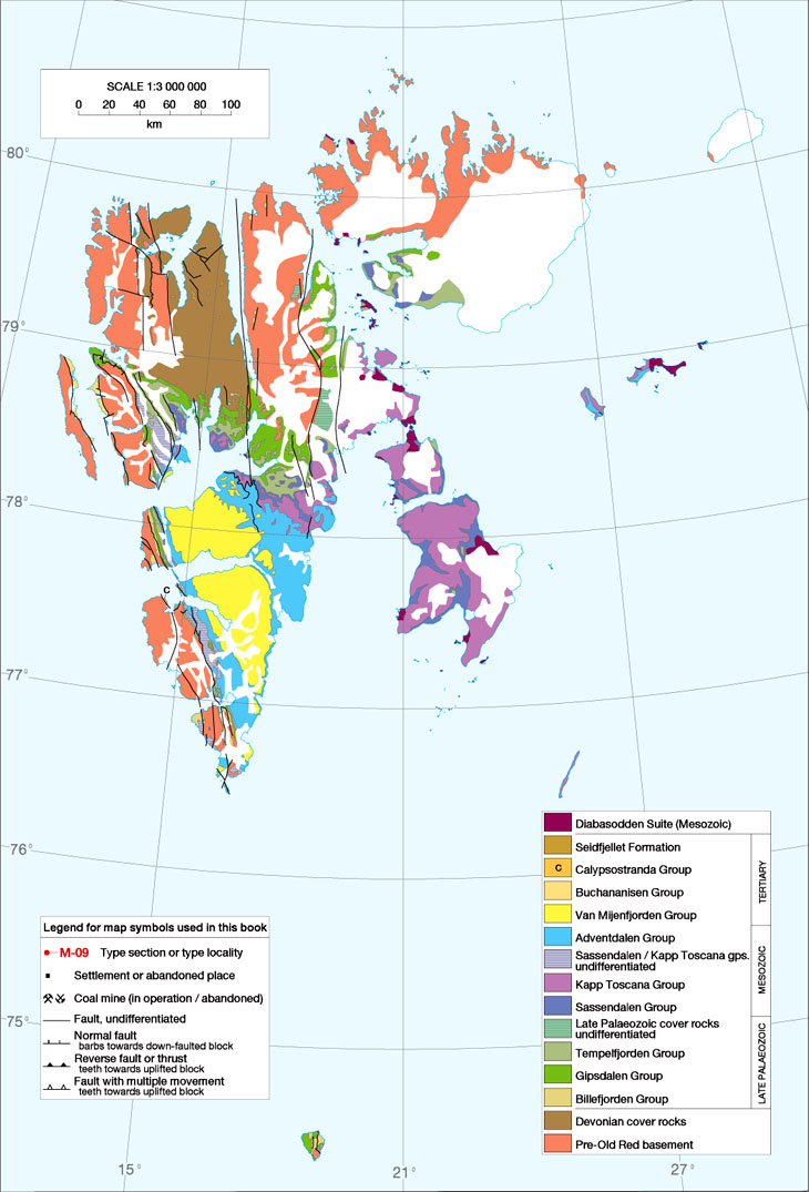
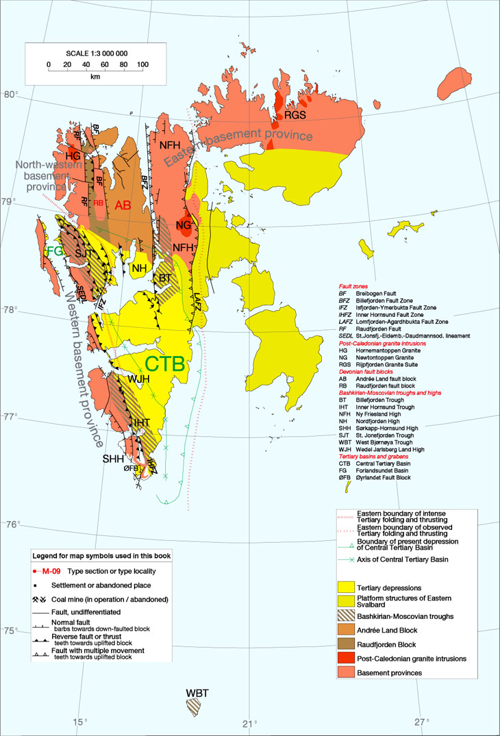
1. INTRODUCTION

WINFRIED K. DALLMANN


1.1 About this site
  1.2 Committee on the Stratigraphy of Svalbard: Organisation and purpose
  1.3 How to use this site – important user information
     1.3.1 Main objectives of this site
     1.3.2 Organisation of the site
     1.3.3 Use of ID numbers and quotation marks
     1.3.4 Stratigraphic tables and applied ages
     1.3.5 Type localities and type sections
     1.3.6 Maps
     1.3.7 Correlations with the geology of the Barents Sea Shelf
     1.3.8 Change of place-name segments
     1.3.9 Lower boundary definitions and descriptions of geological units
     1.3.10 Notes on references
     1.3.11 Explanations of place names
     1.3.12 Transliteration of Russian names and references
  1.4 Outline of the geological history of Svalbard
     1.4.1 Tectonic setting
     1.4.2 Pre-Old Red
     1.4.3 Old Red (Devonian)
     1.4.4 Late Palaeozoic
     1.4.5 Mesozoic
     1.4.6 Cenozoic
     1.4.7 Cenozoic and Quaternary volcanic activity


1.1 About this site

For the last 15 years or so, Norwegian geologists have been working on the registration and regulation of stratigraphic nomenclature for geological units in Norway. The need for registration and proper definition of stratigraphic names in a central database had long been obvious. With the increase of geological knowledge and literature, the amount of imprecise geological unit names was growing rapidly. Imprecise names in this sense are understood as those not welldefined, or not used according to previously published definitions, or with definitions that are problematic in relation to more recent understanding of the regional geological framework.
A formalisation of the nomenclature was needed in order to distinguish between formally established unit names, informal working names, and traditional names that were not defined according to modern requirements. Especially with the onset of oil exploration on the Norwegian continental shelves, where insufficient geographical names are available, the variety of names grew dramatically, threatening to form a jungle impenetrable for the average, non-initiate scientist.
In 1982, the Norwegian Committee on Stratigraphy (Norsk Stratigrafisk Komité, NSK) was established by the Norwegian Council of Geology (Norsk Geologiråd). The committee consists of representatives of all major Norwegian geological institutions and oil companies, as well as a representative of the Norwegian Language Council (Norsk språkråd). The committee's first main task consisted of establishing rules and recommendations for naming geological units in Norway, based on international agreements, but specially aimed at Norwegian conditions. This project was successfully completed with the publication of "Rules and recommendations for naming geological units in Norway" in Norwegian (Nystuen 1986) and, subsequently, in English (Nystuen 1989).
The second main task was to establish a database at the Norwegian Geological Survey (Norges Geologiske Undersøkelse, NGU) in Trondheim, where all geological unit names are to be registered. The number of names registered and defined there is considerable by now. Newly established names have to undergo an approval procedure through NSK prior to their publication in Norwegian journals in order to ensure their accordance with the nomenclature rules, a measure not always appreciated, but generally accepted by individual authors.
In Svalbard, the history of geological names is unique, due to the pronouncedly international research carried out on the archipelago. Geologists from Norway and the Soviet Union, two of the main active nations, tried to communicate as much as possible for many years, but the political situation did not always permit sufficient and fast enough exchange of information. In places, different stratigraphic schemes developed in the respective countries. Geologists from other countries, especially the United Kingdom and Poland, also made significant contributions to the geological exploration of Svalbard, and also to the increasing numbers of unit names.
To avoid confusion without being able to offer immediatesupport, NSK initially considered names from Svalbard published prior to the publication of the "Rules and recommendations for naming geological units in Norway" (1986), as formal ones. Dissatisfaction with the situation, notably at the Norwegian Polar Institute which is responsible for the geological mapping programme in Svalbard, led to the establishment of the Committee on the Stratigraphy of Svalbard (Stratigrafisk Komité for Svalbard, SKS) in 1990. SKS gathered representative stratigraphers from the major research environments with interest in the subject and placed itself under the umbrella of NSK. The aim of SKS was (a) to collect and define all names ever given to rocks in Svalbard and to register them in the NSK database, and (b) to work out and recommend a formalised lithostratigraphic nomenclature for Svalbard's bedrock, where superfluous names are rejected and, where considered necessary, new names are added.
A helpful step on the way was the lexicon "Stratigrafičeskij Slovar' Špicbergena" edited by Gramberg, Krasil'ščikov and Semevskij and published in Russian in 1990, which covers the major part of previously published unit names with short explanations. SKS edited an English translation (Dallmann & Mørk, eds., 1991).
Compilation of the material presented in the present volume was eventually finished in 1997, and the resulting recommendations approved by NSK in 1995-1998. It is the first of two planned volumes covering the entire bedrock stratigraphy of Svalbard's land areas. The present volume starts with the Carboniferous system, or in places, where sedimentary troughs of mainly Carboniferous age started to develop earlier, with the latest Devonian (Famennian). The second volume is intended to cover the Devonian (more precise: Old Red) and Pre-Old Red basement stratigraphy. The reason for this subdivision is twofold: First, the presentation of the Devonian is more similar to that of the older rocks, with many informal unit names and the general lack of logged type sections, in contrast to the Upper Palaeozoic and younger strata. Second, ongoing mapping projects in the Devonian of Svalbard indicate that many changes of the present nomenclature will be necessary in the near future. Postponing the Devonian to a joint publication with the older stratigraphy in a few years' time will probably result in a significantly better and more up-to-date presentation.

Back on top

1.2 Committee on the Stratigraphy of Svalbard: Organisation and purpose

The Committee on the Stratigraphy of Svalbard (Stratigrafisk Komité for Svalbard, SKS) was established by the Norwegian Council of Geology (Norsk Geologiråd) through the Norwegian Committee on Stratigraphy (Norsk Stratigrafisk Komité, NSK). Its aim was primarily defined to elaborate a unified, formal lithostratigraphic nomenclature for the pre-Quaternary bedrock succession of the land areas of Svalbard. The committee's proposals are to be approved by the Norwegian Committee on Stratigraphy prior to their publication.
SKS is composed of working groups (subcommittees) or individuals each being responsible for one lithostratigraphic section or an area. These working groups are consultative to the main committee which is in charge of submitting the proposals to the Norwegian Committee on Stratigraphy.
The member composition hopefully reflects the variety of research groups and exploration companies doing stratigraphic work in Svalbard. Nevertheless, members do not participate on behalf of their affiliation, but on the basis of their own scientific competence.
SKS is obliged to follow the Rules and recommendations for naming geological units in Norway published in Norsk Geologisk Tidsskrift, Vol. 66, supplem. 1, 1986 (in Norwegian) and Vol. 69, supplem. 2, 1989 (in English).


Composition of the main committee during compilation of the present work:

Winfried Dallmann, chairman (Norwegian Polar Institute, Norway)
Krzysztof Birkenmajer (Polish Academy of Sciences, Poland)
Henning Dypvik (University of Oslo, Norway)
David Gee [University of Uppsala, Sweden - participate in work related to the Pre-Old Red or Old Red (mainly Devonian) not treated in this site]
John Gjelberg (Norsk Hydro ASA, Norway)
W. Brian Harland (University of Cambridge, United Kingdom)
Natascha Heintz [University of Oslo, Norway - participate in work related to the Pre-Old Red or Old Red (mainly Devonian) not treated in this site]
Audun Hjelle [Norwegian Polar Institute, Norway - participate in work related to the Pre-Old Red or Old Red (mainly Devonian) not treated in this site]
Hilde Keilen (Saga Petroleum ASA, Norway)
Aleksandr A. Krasil'ščikov [Polar Marine Geological Expedition, PMGRĖ , Russia - participate in work related to the Pre-Old Red or Old Red (mainly Devonian) not treated in this site]
Atle Mørk (IKU Petroleum Research, Norway)
Jenø Nagy (University of Oslo, Norway)
Arvid Nøttvedt (Norsk Hydro ASA , Norway)
Yoshihide Ohta [Norwegian Polar Institute, NP, Norway - participate in work related to the Pre-Old Red or Old Red (mainly Devonian) not treated in this site]
Tatjana M. Pčelina (VNIIOkeangeologija, Russia)
Ron Steel (University of Bergen, Norway; now University of Wyoming, USA)
David Worsley (Saga Petroleum ASA, Norway)

Back on top

1.3 How to use this site – important user information

1.3.1 Main objectives of this site
  • Svalbard is the Norwegian administrative name for the Arctic archipelago situated between 74° and 81° North, and 10° and 34° East. The lexicon deals in particular with the land areas of Svalbard, including Bjørnøya (Bear Island). See Section 1.3.7 for remarks on the inclusion of offshore areas.
  • The first purpose of this site is to present a complete overview of the lithostratigraphic units of Svalbard (Late Palaeozoic and younger), with their geographical distributions, definitions, descriptions, type sections, literature references and other related information.
  • All stratigraphic names ever published are intended to be contained in this site. Those names not recommended for future use are only provided with concise explanations and references to the recommended alternative names.
  • The other purpose of this site is to "tidy up" the equivocal, and sometimes imprecise, use of names and nomenclature schemes in the geological literature of Svalbard. The site recommends a revised lithostratigraphic nomenclature which will hopefully guide the future use of stratigraphic names in the area.
  • The recommendations of nomenclature suggested herein are based on several years' committee work and have passed a process of approval by the Norwegian Committee on Stratigraphy. This approval widely ensures the proper use of the recommended names according to international nomenclature rules. Nevertheless, there are diverging opinions among scientist – in parts even among the authors – about several parts of the presented stratigraphic schemes. This divergence is discussed in the individual chapters of the site. The resulting recommendations reflect the opinion of the majority of scientists involved, but must certainly not be misunderstood as a directive.
  • The authors are fully aware that future research will lead to adjustments, and possibly major changes, of the stratigraphic nomenclature. The present recommendation is thought to be a guide line for those using nomenclature as a tool, and an up-to-date starting point for stratigraphers working on the further development of the stratigraphic framework of the Arctic archipelago of Svalbard and the Barents Sea.


1.3.2 Organisation of the site

1.3.3 Use of ID numbers and quotation marks
  • All recommended stratigraphic units are contained in the lexicon parts of the main chapters. These units have ID numbers with prefixes indicating the related era (CP for Late Palaeozoic or Carboniferous/Permian, M for Mesozoic, T for Cenozoic, Q for Quaternary). The ID numbers are used throughout the site and can be used to quickly find and identify a respective unit on tables, lists, log diagrams, type localities, etc.
  • Previous names that are not recommended for future use by SKS are written in quotation marks throughout the site. These have short explanations and are listed at the end of each chapter.


1.3.4 Stratigraphic tables and applied ages

1.3.5 Type localities and type sections
  • All type sections in this site are redrawn from the originals according to a technical standard established for this purpose at Norsk Polarinstitutt.
  • A fold-out legend for all type sections is contained at the inside of the back cover.
  • The extremely varying standards, quality and scientific foci of the original sections made it impossible to redraw them according to a scientifically uniform standard. This means that differentiation made in some sections (e.g. sandstone, silty sandstone, siltstone, sandy shale, shale) may not be made in others (e.g. sandstone, siltstone, shale). In most cases, the original quality of information is maintained, although generalisation was undertaken where the purpose of technical standardisation required this.
  • As a result of this, for instance, some original sections show a very rough grain size classification, different ways of particle classification (e.g. for carbonate rocks), or none at all which would satisfy the presently accepted standard grain size scale. These sections are adapted to the standard scale, with the note "grain size approximate".
  • Almost all redrawn sections have been checked and accepted by the authors of the originals or by a research partner or supervisor. For a few older sections, this was, of course, not possible.
  • Where newer and more informative logs of a previously defined type section existed, these new sections are used here. The reference to the original definition is only shown in the text.
  • Different kinds of type localities and sections used in this site:
    • Stratotype: The main type locality and section which presently define the unit. Due to the often poor documentation of other previously defined type localities, the term neostratotype is not applied, but previously defined stratotypes are mentioned in the text.
    • Hypostratotype: The second or third type locality of a unit that documents major regional variations. Hypostratotypes for some units in Svalbard are defined herein for the first time.
    • Boundary stratotype and Unit stratotype: If a unit does not have a documented locality where both its base and its main body are sufficiently represented, type localities for the lower boundary and the main unit body are defined separately. The use of boundary and unit stratotypes is here introduced to Svalbard stratigraphy.
  • The name-giving localities of stratigraphic units in Svalbard rarely coincide with their type localities. The reason for this is that unit names mostly have not been changed since their first appearance or definition in the geological literature, when type localities were not sufficiently documented. Later, better type localities were often found and documented in different places. Another reason may be the lack of geographical names in the area of the type locality, or the use of the same type locality for several units.
  • Availability of cores from type wells: For most Mesozoic type wells, apply to the Norwegian Petroleum Directorate (NPD). For cores from wells containing the letter U in the well number, apply to SINTEF Petroleum Research. For cores from Cenozoic type wells, apply to Kings Bay A/S in Ny-Ålesund, Svalbard.


1.3.6 Maps
  • Maps in the introductory chapter: The overview maps show the distribution of stratigraphic groups (Fig. 1-04), major structural elements (Fig. 1-05), and the position of all detailed maps and the names of major geographical areas frequently mentioned in the text (Fig. 1-06).
  • The other maps show the geographical distributions of formations. Sets of maps show the formations of Late Palaeozoic, Mesozoic and Cenozoic age, while rocks of other ages are only subdivided into major complexes.
  • For the geographical distribution of units with a lower stratigraphic rank (members, beds) the reader is referred to the text. The exact distribution of many of these units is still poorly known.
  • Ages indicated roughly in the legend of these maps are meant for general orientation. See age sections in the lexicon parts for more comprehensive information.
  • The maps are not tectonic maps. To keep the map information clear, only faults that have influenced either the deposition of the respective stratigraphic interval or its present outcrop pattern, are shown. For instance, faults bounding Carboniferous troughs are not shown on the maps belonging to the chapters on Mesozoic or Cenozoic stratigraphy, while faults displacing only Mesozoic and Cenozoic rocks at the surface do not occur on the maps in the Late Palaeozoic stratigraphy chapter. For fault symbols used on the detailed maps, see legend on the overview maps (Figs. 1-04, 1-05).
  • The positions of all type localities are indicated by the ID number of the respective unit (section 1.3.3). Type localities which are not provided with a stratigraphic log are also shown in this way.
  • Most geographical names used in the text, including name-giving or type locality names, are shown on the maps.
  • References to sources of map data are too abundant to be indicated on the maps. Most information is referred to on the bedrock maps published by Norsk Polarinstitutt, including preliminary editions.


1.3.7 Correlations with the geology of the Barents Sea Shelf
  • During the committee's work on the lithostratigraphic nomenclature, correlations with the stratigraphy of the western Barents Sea Shelf were considered important. Hydrocarbon prospecting in the western Barents Sea has been going on since 1980, and with the expected future developments there, the amount of stratigraphic names will increase. Svalbard is often used as a reference and training area by offshore geologists working in the Barents Sea. It is the committee's opinion that the lithostratigraphic nomenclature systems should clearly show the relationship between the onshore and offshore development and that the framework of stratigraphic groups should reflect this relationship.
  • The Late Palaeozoic stratigraphic nomenclature of the offshore areas is presently being worked on by another committee in close co-operation with NSK. Its work is not yet concluded, but there is a general consensus that the framework at group level will be applied from Svalbard, while an additional group is defined in the western Barents Sea, with only one formation represented onshore on the island of Bjørnøya. Available data points on the Upper Palaeozoic of the Barents Sea Shelf are still sparse.
  • The nomenclature of the Mesozoic stratigraphy in the western Barents Sea has preliminarily been established in connection with the present work. Abundant data are available, although published data are mainly restricted to the Hammerfest Basin. The overall group framework proposed here will probably be applicable for a long time ahead, while adjustments or additions at lower levels are expected. Work on the offshore Mesozoic nomenclature has made significant progress and Mesozoic offshore formations are included in the present volume.
  • The stratigraphy of the Cenozoic offshore basins is not yet well enough known. Cenozoic offshore basins probably developed separately from those exposed onshore.


1.3.8 Change of place-name segments
  • Place names in Svalbard have changed significantly throughout history. One reason is the international use of Svalbard through the last centuries. Norway did not start to execute her sovereignty earlier than 1925 (according to the Svalbard Treaty of 1920), when names from other languages gradually started to be translated into Norwegian. Even later, Norway started to pursue the policy of naming – and renaming – places according to spelling in the less wide-spread of the two Norwegian languages, Nynorsk. Many modern, revised spellings did not occur on maps or publications previous to the 1990s. For these reasons, many place-name segments of stratigraphic units do not coincide with the spelling of the respective place names on modern maps, which is disadvantageous.
  • SKS has adopted the new spellings for those place names where changes were minor, and where the original name is easily recognised (e.g.: Petrelskardet Formation – Petrellskaret Formation).
  • SKS has changed incomplete place names into complete ones in order to avoid formation names with a first segment reflecting, for instance, a person rather than a mountain (e.g.: Vegard Formation – Vegardfjella Formation).
  • SKS has not adopted translations of names from, for instance, original English place names (ex.: Wood Bay – Woodfjorden, for a Devonian formation), or other major changes where the original place name would then not be easily recognised.


1.3.9 Lower boundary definitions and descriptions of geological units
  • This lexicon is attempting to standardise descriptive data from a huge variety of original sources and authors. The various geological units have been investigated and described for different purposes and with a varying quality in the geological literature. It was therefore not always possible, on the basis of existing data, to achieve a consistent way of description. So, for instance, while some units may lack a reference to an interpretation of the depositional environment, others may lack sufficient data on lateral facies variations, etc.
  • To avoid much repetition, some features may be described for a superior rank unit (e.g. formation), without being repeated in the description of the inferior rank units (members), or vice versa, depending on what appeared to be most appropriate. The user of the lexicon is therefore asked always to check superior and inferior rank units in order to find the requested information.
  • A good definition of its lower boundary is an important property of any geological unit. The great variety of authors of different nations defining these units in Svalbard may result in an inconsistent quality of lower boundary definitions. In many cases, geological units were defined without a proper definition of their lower boundary. These units may still have survived history and be accepted by present geologists as "good" units, simply because they designate characteristic rock successions. Many lower boundary definitions, a demand of modern lithostratigraphy, have therefore been added by the authors of this lexicon as precisely as possible from the existing data. For a number of units, especially for those with interfingering contacts or transitional boundary features, these definitions may appear rather arbitrary.


1.3.10 Notes on references

1.3.11 Explanation of place names
  • Place names in Svalbard which have been used for stratigraphic unit names, have either a descriptive meaning, or are from persons, vessels, etc. Descriptive meanings are translated in the lexicon part of the site, because these names may have geological implications.
  • For other place names, and for more information about the names, the reader is referred to 'Place names in Svalbard', Norges Svalbard- og Ishavsundersøkelser (1942) and Orvin (1958), both reprinted by Norsk Polarinstitutt (1991).


Explanation of common place-name endings:
   - bekken: Creek
   - berget: Mountain
   - breen: Glacier
   - bukta: Bay
   - byen: Town
   - dalen: Valley
   - egga: Crest
   - elva: River, Creek
   - fjella: Mountains
   - fjellet: Mountain
   - fjorden: Fiord, Inlet, Firth
   - flya: Plateau
   - fonna: Ice Cap
   - halvøya: Peninsula
   - hamna: Harbour
   - haugen: Hill
   - hatten: Hat
   - heia: Hill
   - heim: Home, Hut
   - hornet: Horn, Peak
   - høgda: Hill
   - huken: Point
   - isen: Ice, Glacier
   - kammen: Crest, Ridge
   - kampen: Top
   - kanten: Edge
   - Kapp: Cape
   - kjegla: Cone
   - laguna: Lagoon
   - Land: Land
   - neset: Point, Cape
   - nuten: Summit
   - odden: Point, Cape
   - øya: Island
   - passet: Pass
   - pynten: Point, Cape
   - ryggen: Ridge
   - salen: Saddle
   - såta: Haystack (cone-shaped mountain)
   - skaret: Notch, Pass
   - sletta: Plain
   - stranda: Beach
   - sund: Sound
   - tangen: Point, Cape
   - tind(en): Peak
   - toppen: Summit
   - vågen: Bay
   - vatnet: Lake
   - vika: Bay/Cove

1.3.12 Transliteration of Russian names and references
Russian names and references correspond to the ISO (International Standard Organisation) transliteration, which – with a very minor deviation – is also used in the International Bibliographic System. The advantage of this transliteration compared with national transcriptions, such as the English transcription, is its reversibility. Russian names transcribed in English or other languages cannot unequivocally be transcribed back into the Cyrillic alphabet; this may cause problems when inquiring for authors, or when looking for place names on Russian maps. Unfortunately, various electronic databases and international journals have adopted the English transcription. For this reason, a onversion table is added below (
Fig. 1-01).

Fig. 1-01: Conversion table for Russian Cyrillic letters, ISO transliteration and English transcription. Be aware that conversion is only valid from Cyrillic or ISO to English, but not vice versa.
      Cyrillic      
      ISO      
      English      
      a             a             a      
      б             b             b      
      в             v             v      
      г             g             g      
      д             d             d      
      е             e             e, ye1      
      ë             ë             e, yo1      
      ж             ž             zh      
      з             z             z      
      и             i             i2      
      й             j             y2      
      к             k             k      
      л             l             l      
      м             m             m      
      н             n             n      
      о             o             o      
      п             p             p      
      р             r             r      
      с             s             s      
      т             t             t      
      у             u             u      
      ф             f             f      
      х             h3             kh      
      ц             c             ts      
      ч             č             ch      
      ш             š             sh      
      щ             šč             shch      
      ъ             ''             (left out)      
      ы             y             y      
      ь             '             (left out)      
      э             ė             e      
      ю             ju             yu      
      я             ja             ya      

1 if first letter in a word or after a vowel;       
2 ий sometimes transcribes "y" in English;
3 in bibliographic transliteration: "ch"           


Back on top

1.4 Outline of the geological history of Svalbard

1.4.1 Tectonic setting

The archipelago of Svalbard is the emergent northwestern corner of the Barents Sea Shelf, which was uplifted by late-Mesozoic and Cainozoic crustal movements. The area provides a splendid insight into the varied geological structure and geo-historical development of the northwestern Barents Sea since the Palaeoproterozoic. The geological record ranges from possible Archean to Recent and shows a multiorogenic development with prominent tectonic events of Grenvillian (late-Mesoproterozoic), Caledonian (Ordovician-Silurian), Ellesmerian or Svalbardian (Late-Devonian), Variscan (Mid-Carboniferous) and Alpidic (Early-Cenozoic) age.
North of Svalbard, 50-100 km from the shore, a steep passive continental margin with slopes up to 10° (average 4°) forms the boundary with the Eurasian Basin of the Arctic Ocean. Offshore to the west of Svalbard, a 40-80 km wide shelf separates the coast of the main island, Spitsbergen, from a structurally complex oceanic area, the Knipovich Ridge (Talwani & Eldholm 1977). The central part of this ridge is a spreading axis which is segmented by a transform fault system, the Spitsbergen Fracture Zone in the north, and the Greenland Fracture Zone in the south (Fig. 1-02).


Fig. 1-02: Geological overview map of Svalbard and the western Barents Sea Shelf, showing the positions of major tectonic elements. Offshore data are mainly from Sigmond (1992); faults north of the Bjarmeland platform are added from unpublished data (Norwegian Petroleum Directorate, 1998) and refer to the top Permian level. The indicated type wells refer to Mesozoic offshore formations defined in Mesozoic Chapter.


The northwestern shelf corner borders the Yermak Plateau, the northern part of which may be the remainder of an Early-Cenozoic hot spot (Feden et al. 1979). Late-Cretaceous thermal uplift, Early-Cenozoic shoulder uplift along the rifted margin of the developing Arctic Ocean, and subsequent transform movements in a periodically transpressive regime along the western margin may all have their share in explaining the uplift of the archipelago and especially of its western and northern reaches.

1.4.2 Pre-Old Red

The term Pre-Old Red is here applied for the rocks already present under the main Caledonian orogenic phase in the Middle Silurian. The literature on the geology of Svalbard often applies the term 'Hecla Hoek' to this basement. There has been confusion about this name due to its original definition (Nordenskiöld 1863) and the later elaborated complexity of the Pre-Old Red strata causing several redefinitions (Orvin 1940; Harland & Wilson 1956; Krasil'ščikov 1970, 1973).
The Pre-Old Red succession is exposed in the west and north of the archipelago. It has long been considered to be mainly the product of the Caledonian orogeny, though distinctive unconformities have been reported from southern Spitsbergen (e.g. Birkenmajer 1975, 1991; Bjornerud 1990) and Nordaustlandet (e.g. Flood et al. 1969; Ohta 1982). Since the late 1980s, U-Pb zircon isotopic age determination has revealed several Precambrian events (e.g. Ohta 1994; Gee et al. 1994). The Pre-Old Red thus has a polyorogenic development: Baikalian movements (600-650 Ma), the Grenvillian tectonothermal event (950-1000 Ma), and indications of earlier events recognised in several areas (ca. 1400 Ma, 1700-1800 Ma, and two or three older ones; Ohta 1992) are followed by two distinct Caledonian foldthrust events, including evidence for an oceanic suture zone in the Western province.
The Pre-Old Red is subdivided into three different tectonostratigraphic "basement provinces", whose structure, sedimentary record and tectonothermal evolution differ from each other. Their juxtaposition occurred probably during the Caledonian period, though no consensus about the involved mechanisms yet exists (Harland 1969, 1971; Birkenmajer 1981; Ohta et al. 1989; Ohta 1994). After the Middle Silurian, however, Svalbard formed part of the 'Old Red Continent'.

1.4.3 Old Red (Devonian)

During the Devonian Period, Svalbard experienced the deposition of a vast thickness of Old Red molasse sediments which are mainly preserved in a down-faulted crustal block in northern Svalbard, bounded by the northwestern and eastern basement provinces. The main tectonic overprint and tectonic style of this graben system is related to a Late- Devonian culmination of tectonism, the 'Svalbardian Phase', which resulted in contractional movements predominant in northern Svalbard (Orvin 1940). The Svalbardian Phase is normally considered to be a late, post-molassestage phase of the Caledonian orogeny and may be related to the Ellesmerian-North Greenland Foldbelt deformation in the Canadian Arctic and northern Greenland.

1.4.4 Late Palaeozoic

During the Carboniferous Period, Svalbard developed from a site of fault block tectonism with differential sedimentation to a stable shelf that experienced overall subsidence (except for southern Spitsbergen). A local (?) phase of folding and thrusting, only locally recorded on southern Spitsbergen, occurred possibly in the Visean ('Adriabukta event': Birkenmajer 1964; Dallmann 1992). The main fault block movements occurred in the Bashkirian and Moscovian, resulting in a new constellation of troughs, mainly halfgrabens, with a syntectonic sedimentary record, developed along older tectonic lines (Gjelberg & Steel 1981). With waning tectonic movements in the later Carboniferous, most of Svalbard developed into a carbonate platform with episodes of evaporite formation. These conditions lasted through the Early Permian, while the later part of the Permian experienced renewed clastic influx and a subsequent hiatus at the era boundary (Steel & Worsley 1984). Late-Palaeozoic sedimentation in the Svalbard/Barents Sea area was continuous with that in the Wandel Sea Basin in northeastern Greenland (Håkansson & Stemmerik 1984), a site at that time situated not farther than maybe 100 km from what is now the western coast of Svalbard.

1.4.5 Mesozoic

The Mesozoic stratigraphic record consists of repeated clastic sedimentary successions, mainly delta-related coastal and shallow shelf sediments (Triassic-Early Jurassic), deeper shelf sediments (Middle Jurassic to earliest Cretaceous) and again shallow shelf/delta deposits (later part of Early Cretaceous). The source area of the sediments was mainly situated in the west, and later also in the north, while the basin opened towards the present Barents Sea (Steel & Worsley 1984). This view is consistent with the less complete Mesozoic sections in the Wandel Sea Basin of NE Greenland (Håkansson et al. 1991). Early Jurassic block faulting and development of sedimentary basins during the Cretaceous in the Wandel Sea Basin are explained by the Mesozoic onset of transform faulting between Greenland and the Barents Sea (Birkelund & Håkansson 1983; Håkansson et al. 1991). In Svalbard, no such tectonics are seen, and the entire Upper Cretaceous is lacking due to an overall uplift, with highest uplift rates in the northwest.
The first sign of break-up between Greenland and Europe and the opening of the Arctic and North Atlantic oceans recorded in Svalbard is the intrusion of dolerites from the latest Jurassic through the Early Cretaceous (Burov et al. 1977). They occur most commonly as sills in Carboniferous through to Jurassic strata (progressively younger to the east). On Kong Karls Land, in eastern Svalbard, basaltic lavas were extruded during the later part of the Early Cretaceous. They belong to a larger volcanic province which also includes large parts of the Barents Sea and Franz Joseph Land.

1.4.6 Cenozoic

The opening of the Arctic and North Atlantic oceans caused a tectonic overprint with convergent structures in the Paleocene and Eocene. Structures that developed were related to a transform fault system, the Spitsbergen Fracture Zone, or "De Geer Fault", situated offshore to the west of Svalbard (
Fig. 1-02). Convergent movements during part of the transform movement caused the reverse uplift of the western basement province, thrusting the basement rocks and overlying cover strata onto the simultaneously developing foreland basin, the Central Cenozoic Basin (Steel et al. 1985). Though associated with a major, dextral plate transform setting between the Greenland and Barents shelves and previously described as a typical transpressive orogen (Harland 1969; Harland & Horsfield 1974; Lowell 1972), the Cenozoic fold-thrust belt consists mainly of convergent structures (e.g. Maher et al. 1986; Nøttvedt et al. 1988; Dallmann & Maher 1989; Haremo et al. 1990; Bergh & Andresen 1990). This led to a decoupling model (Nøttvedt et al. 1988; Maher & Craddock 1988), meaning that strike-slip and convergent movements may be localised in different deformation zones. Recent work revealed the local existence of additional strike-slip-related structures along several N-S oriented fault zones (Dallmann 1992; McCann & Dallmann 1996; Maher et al. 1997).
ENE-WSW shortening was transferred east ahead of the fold belt along high level detachments within the cover sediments, and interfered with renewed, reverse faulting along basement-involved structures farther east (Billefjorden and Lomfjorden faultzones; Haremo et al. 1990; Haremo & Andresen 1992; Haremo et al. 1993; Miloslavskij et al. 1993).
During later stages of foldbelt development (Eocene-Oligocene), minor sedimentary basins (especially the Forlandsundet Basin) developed in westernmost areas. Their structural record is complex and difficult to relate to the deformation phases of the main foldbelt (Gabrielsen et al. 1992, Kleinspehn & Teyssier 1992). The latest tectonic overprint was an overall E-W extension that affected more or less all favourably oriented earlier faults and generated new faults in the foldbelt area. These fault movements must be seen in the context of the post-Eocene development of a passive continental margin to the west, when Svalbard, drifting along the transform fault system, had separated from the continental shelf of Greenland.

1.4.7 Cenozoic and Quaternary volcanic activity

Volcanic activity of both Cenozoic and Quaternary age occurred in NW Spitsbergen, overlying Devonian and Precambrian rocks. The Cenozoic volcanites are plateau basalts (transitional olivine basalts) of mainly Miocene to Pliocene age (Burov & Zagruzina 1976; Prestvik 1978), while the Quaternary volcanites are volcanic centres (off-ridge alkali basalts) situated on faults that date back at least to the Devonian; their age is probably between 100,000 and 250,000 years (Skjelkvåle et al. 1989). Hot springs in several places in northwestern and southern Spitsbergen witness to continuously high geothermal gradients along the Cenozoic foldthrust belt.

Fig. 1-03
Fig. 1-03: Table of post-Caledonian tectonic events and character of sedimentation in Svalbard. The absolute age scale refers to Haq & van Eysinga (1987).


Fig. 1-04
Fig. 1-04: Geological overview map of Svalbard showing lithostratigraphic groups. Legend for symbols used on all maps.


Fig. 1-05
Fig. 1-05: Overview map of Svalbard showing major structural elements. Legend for symbols used on all maps.


Fig. 1-06
Fig. 1-06: Map of Svalbard showing names of major geographical features and an index of detailed maps.


Back on top