|
[ Storfjorden Subgroup | Tschermakfjellet Formation | De Geerdalen Formation | Skuld Formation ]
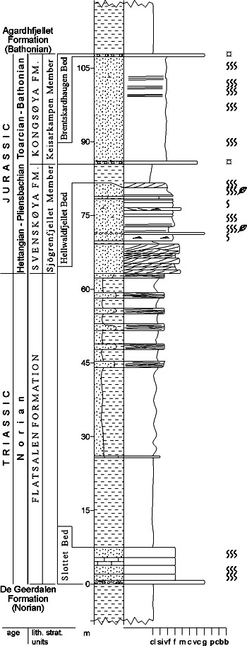
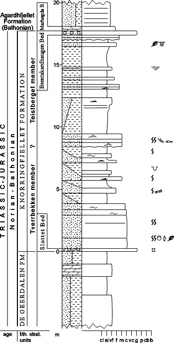
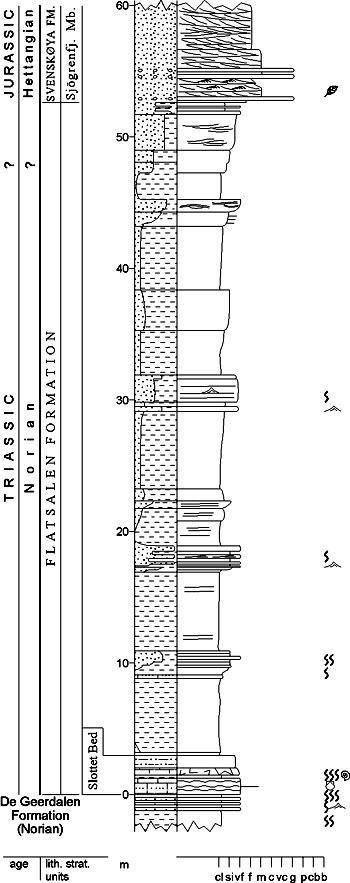
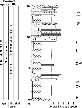
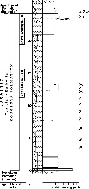
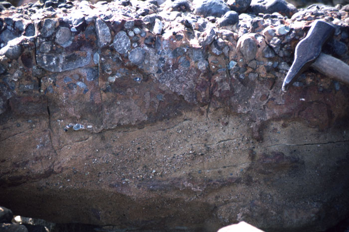
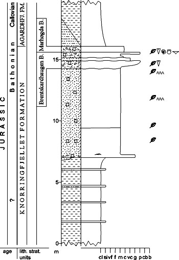
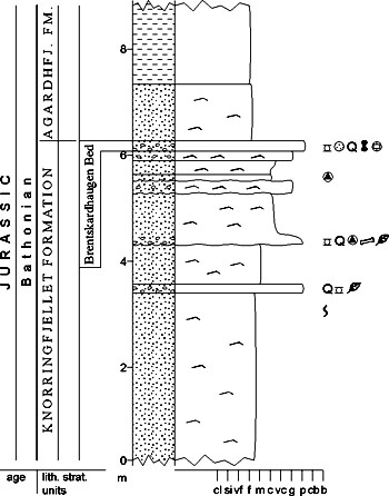
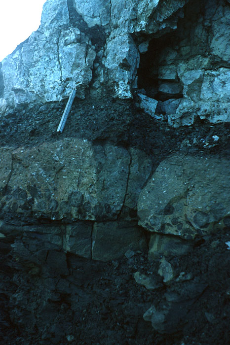
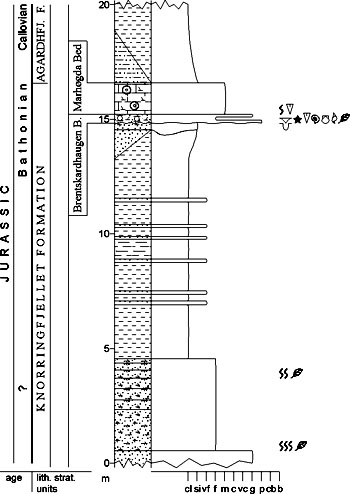
[ Snadd Formation | Wilhelmøya Subgroup | Smalegga Formation | Knorringfjellet Formation ] [ Flatsalen Formation | Svenskøya Formation | Kongsøya Formation | Realgrunnen Subgroup ] [ Fruholmen Formation | Tubåen Formation | Nordmela Formation | Stř Formation ] KAPP TOSCANA GROUP (M-31)  STATUS OF UNIT: Formal FIRST USE OF NAME: Buchan et al. 1965 CURRENT DEFINITION: Harland et al. 1974; herein extended to comprise coeval deposits on the Barents Sea Shelf SYNONYM(S) AND REFERENCE(S): Kapp Toscana "Formation": Buchan et al. 1965 ORIGIN OF NAME: Kapp Toscana: A cape on the southern coast of Van Keulenfjorden TYPE AREA: Central eastern Spitsbergen STRUCTURAL SETTING: Barents Sea Shelf (including Svalbard) DEPOSITIONAL AGE: Carnian to Bathonian OVERLYING UNIT(S): Adventdalen Group UNDERLYING UNIT(S): Sassendalen Group SUPERIOR UNIT: None OTHER USE OF NAME: None THICKNESS: Up to >475 m in Svalbard, up to 2000 m (?) on Barents Sea Shelf MAIN LITHOLOGIES: Shale, siltstone, sandstone DESCRIPTION: The Kapp Toscana Group comprises shales, siltstones and sandstones of Late Triassic to Middle Jurassic (Bathonian) age in Svalbard and on the Barents Sea Shelf (Figs. 3-40, 3-41). 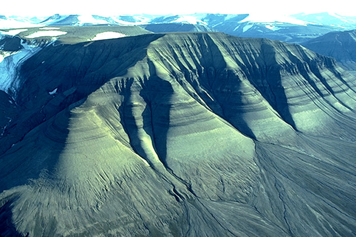
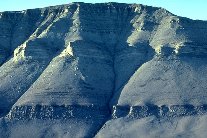
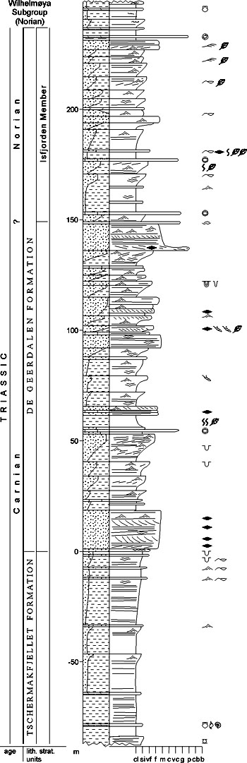
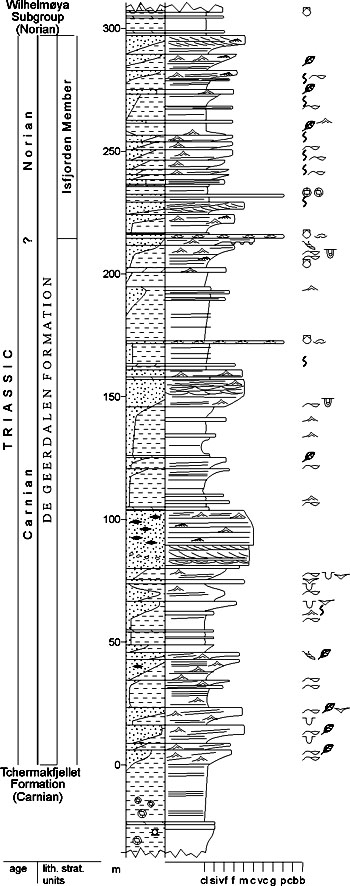
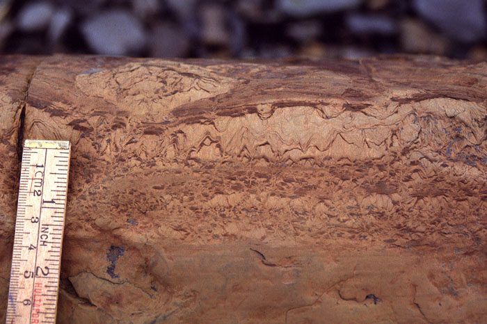
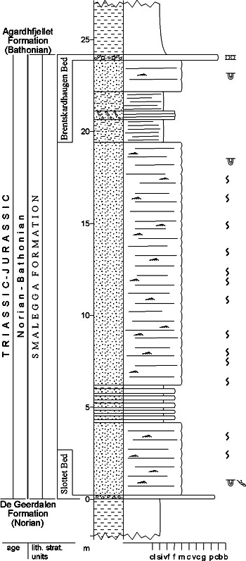
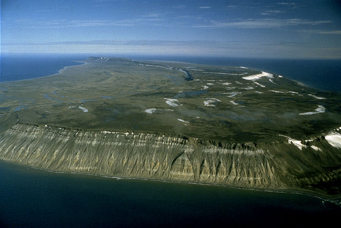
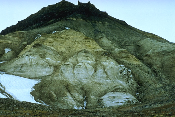
Fig. 3-40: Milne Edwardsfjellet, central Spitsbergen: The Kapp Toscana Group forms the upper third of the slope, starting with the thin shales of the Tschermakfjellet Formation resting on top of the Botneheia Formation. The upper sandstone succession is the De Geerdalen Formation. The lower two thirds of the mountain represent the Sassendalen Group (Vikinghøgda and Botneheia formations; compare Fig. 3-24). Photo: A. Mørk The Kapp Toscana Group has been deposited in a generally nearshore, deltaic environment and is characterised by shallow marine and coastal reworking of deltaic and fluviodeltaic sediments (Mørk et al. 1982). STORFJORDEN SUBGROUP (M-32)  STATUS OF UNIT: Formal FIRST USE OF NAME: Here CURRENT DEFINITION: Here SYNONYM(S) AND REFERENCE(S): None ORIGIN OF NAME: Storfjorden (transl. "The Big Inlet"): The strait between Spitsbergen and the eastern islands Edgeøya and Barentsøya TYPE AREA: Eastern Spitsbergen STRUCTURAL SETTING: Barents Sea Shelf (including Svalbard) DEPOSITIONAL AGE: Late Triassic OVERLYING UNIT(S): Wilhelmøya and Realgrunnen subgroups UNDERLYING UNIT(S): Sassendalen Group SUPERIOR UNIT: Kapp Toscana Group OTHER USE OF NAME: None THICKNESS: Up to 350 m on Svalbard, up to 1400 m on the Barents Sea Shelf MAIN LITHOLOGIES: Shale, siltstone, sandstone DESCRIPTION: The Storfjorden Subgroup includes the Tschermakfjellet, De Geerdalen, Skuld and Snadd formations, i.e. the compositionally immature lower part of the Kapp Toscana Group representing shallow shelf, pro-delta to delta top depositional environments. TSCHERMAKFJELLET FORMATION (M-33)  DISTRIBUTION shown on figs.: 3-06, 3-07, 3-08, 3-09, 3-10, 3-12 STATUS OF UNIT: Formal FIRST USE OF NAME: Buchan et al. 1965 CURRENT DEFINITION: Mørk et al. 1982; slightly revised herein to include the "Austjøkelen Formation": Mørk et al. 1982 SYNONYM(S) AND REFERENCE(S): Tschermakfjellet "Member": Buchan et al. 1965 ORIGIN OF NAME: Tschermakfjellet: A mountain in Dickson Land TYPE SECTION (Fig. 3-42): Stratotype: Botneheia, northern Nordenskiöld Land DEPOSITIONAL AGE: Early Carnian DATING METHOD: Ammonoids REFERENCE(S) FOR AGE: Korčinskaja 1982; Dagys et al. 1993 OVERLYING UNIT(S): De Geerdalen Formation UNDERLYING UNIT(S): Bravaisberget and Botneheia formations SUPERIOR UNIT: Storfjorden Subgroup OTHER USE OF NAME: None THICKNESS: 0-30 m on western Spitsbergen, 30-65 m in central and eastern Spitsbergen (51 m in the stratotype), 65-140 m on Barentsøya and Edgeøya MAIN LITHOLOGIES: Shale LOWER BOUNDARY DEFINITION: The base is defined where grey, silty shale with red weathering laminae and nodules of siderite occurs on top of the cliff-forming, darker grey siltand sandstones of the upper part of the Bravaisberget or Botneheia formations. The darker colour of the underlying rocks is due to a higher bitumen content. DESCRIPTION: The Tschermakfjellet Formation consists of dark grey shales with upward increasing intercalated siltstone laminae and corresponding decrease in siderite nodules. Fossiliferous beds with ammonoids, bivalves, gastropods and brachiopods occur in eastern areas. The formation represents a shale-dominated, coarseningupward, pro-delta depositional environment. Back to top DE GEERDALEN FORMATION (M-34)  DISTRIBUTION shown on figs.: 3-06, 3-07, 3-08, 3-09, 3-10, 3-12 STATUS OF UNIT: Formal FIRST USE OF NAME: Buchan et al. 1965 CURRENT DEFINITION: Mørk et al. 1982 SYNONYM(S) AND REFERENCE(S): De Geerdalen "Member": Buchan et al. 1965 ORIGIN OF NAME: De Geerdalen: A valley in northern Nordenskiöld Land TYPE SECTION (Figs. 3-45, 3-46): Stratotype: Storfjellet, central Sabine Land Hypostratotype: Dalsnuten, western Sabine Land DEPOSITIONAL AGE: Carnian - early Norian DATING METHOD: Ammonoids REFERENCE(S) FOR AGE: Tozer & Parker 1968; Korčinskaja 1982 OVERLYING UNIT(S): Wilhelmøya Subgroup UNDERLYING UNIT(S): Tschermakfjellet Formation SUPERIOR UNIT: Storfjorden Subgroup OTHER USE OF NAME: None THICKNESS: 28-180 m in southwestern Spitsbergen, 320 m at outer Isfjorden (Festningen section), ca. 230-300 m in central and eastern Spitsbergen (238 m in the stratotype), up to 400 m (top eroded) on Barentsøya and Edgeøya MAIN LITHOLOGIES: Sandstone, shale LOWER BOUNDARY DEFINITION: The base is defined at the base of the first prominent sandstone unit (metre scale to tens of metres) in the Storfjorden Subgroup. This sandstone may belong to either of the types described below (Figs. 3-45, 3-46). DESCRIPTION: The De Geerdalen Formation consists of repeated coarsening-upward successions from shale to sandstone. In western and central to eastern Spitsbergen, the upper part of the De Geerdalen Formation is dominated by multicoloured shales, alternating with minor coarsening-upward units terminating in silt or sandstone beds (Isfjorden Member). Some reddish siderite beds which contain plant fossils, fossilised logs, coal fragments and cone-in-cone structures are also present. Isfjorden Member (M-35) STATUS OF UNIT: Formal FIRST USE OF NAME: Pčelina 1983 CURRENT DEFINITION: Pčelina 1983 SYNONYM(S) AND REFERENCE(S): Isfjorden "Formation": Pčelina 1983 ORIGIN OF NAME: Isfjorden: (transl. "The Ice Fiord") A major inlet on central Spitsbergen TYPE SECTION (Fig. 3-45): Stratotype: Storfjellet, central Sabine Land DEPOSITIONAL AGE: Early Norian DATING METHOD: Bivalves, conchostracans and palynology REFERENCE(S) FOR AGE: Pčelina 1983; J.O. Vigran, written commun. 1997 OVERLYING UNIT(S): Wilhelmøya Subgroup UNDERLYING UNIT(S): Unnamed SUPERIOR UNIT: Storfjorden Subgroup OTHER USE OF NAME: None THICKNESS: 55-135 m, 87 m in the stratotype MAIN LITHOLOGIES: Shale, mudstone, siltstone, sandstone LOWER BOUNDARY DEFINITION: The lower boundary is defined at the base of a siltstone bivalve coquina bed which occurs above a thick cross-bedded sandstone unit of the De Geerdalen Formation. DESCRIPTION: The Isfjorden Member constitutes the upper part of the De Geerdalen Formation. It consists of alternating shales and evenly bedded, thin- to thick-bedded siltstone and sandstone beds. A siderite nodule bed often occurs some metres above the base, and bivalve coquina beds occur in several sections. The shales may be multicoloured and contain reddened mudstones. Carbonate beds, phosphate nodules and gravel or conglomerate lenses are characteristic. Wave and ripple lamination are common. Plant fragments are abundant, and conchostracans have been found in this member only. The unit was deposited in shallow marine shelf (?locally lagoonal) environments. Back to top SKULD FORMATION (M-36)  DISTRIBUTION shown on fig.: 2-05 STATUS OF UNIT: Formal FIRST USE OF NAME: Krasil'ščikov & Livšic 1974 CURRENT DEFINITION: Mørk et al. 1982 SYNONYM(S) AND REFERENCE(S): "Hahnfjella Formation" on Bjørnøya: Pčelina 1983 ORIGIN OF NAME: Skuld (an Old Norse goddess): One of the mountain summits of Miseryfjellet, Bjørnøya TYPE SECTION (Fig. 3-28): Stratotype: Urd, Miseryfjellet (Bjørnøya) DEPOSITIONAL AGE: Late Ladinian - early Carnian DATING METHOD: Ammonoids, bivalves, palynology REFERENCE(S) FOR AGE: Böhm 1903; Mørk et al. 1990; Dagys et al. 1993 OVERLYING UNIT(S): None UNDERLYING UNIT(S): Urd Formation SUPERIOR UNIT: Storfjorden Subgroup OTHER USE OF NAME: None THICKNESS: 140 m (top eroded) MAIN LITHOLOGIES: Shale, siltstone, sandstone LOWER BOUNDARY DEFINITION: The lower boundary is defined where grey shale with spread red weathering siderite nodules rests on top of the phosphate nodular Verdande Bed. DESCRIPTION: The Skuld Formation (Fig. 3-28) consists of basal shales and four coarsening-upward units from shale to sandstone, the lowermost and uppermost being most pronounced. The sandstones are immature. Siderite nodules occur. Back to top SNADD FORMATION (M-37) OCCURRENCE: Offshore unit, known from the Hammerfest Basin (Fig. 1-02) STATUS OF UNIT: Formal FIRST USE OF NAME: Worsley et al. 1988 CURRENT DEFINITION: Worsley et al. 1988 SYNONYM(S) AND REFERENCE(S): None ORIGIN OF NAME: Snadd: A local Norwegian name for 'ringed seal' (Phoca hispida) TYPE SECTION: Stratotype: Exploration well 7120/12-2. Hypostratotype: Composite; cored exploration well 7120/12-1, 9-2 DEPOSITIONAL AGE: Ladinian - Norian DATING METHOD: Palynology REFERENCE(S) FOR AGE: Worsley et al. 1988 OVERLYING UNIT(S): Realgrunnen Subgroup UNDERLYING UNIT(S): Sassendalen Group SUPERIOR UNIT: Storfjorden Subgroup OTHER USE OF NAME: None THICKNESS: 944 m in the stratotype, 1410 m in the hypostratotype MAIN LITHOLOGIES: Shale, siltstone, sandstone LOWER BOUNDARY DEFINITION: The base of the Snadd Formation is shown by a clear log break at the base of a 60 m shale interval above the mixed lithologies of the underlying unit. The break is marked by a sharp increase to a more uniform response in gamma ray, interval transit time and neutron porosity values. DESCRIPTION: Basal grey shales coarsen upward into shales with interbeds of grey siltstones and compositionally immature sandstones. Limestones and calcareous interbeds are relatively common in the lower and middle parts of the formation, while thin, coaly lenses are locally developed at higher levels. Distinctive dusky, red-brown shales conclude the succession. Lateral and vertical lithological variations may provide the basis for a future member subdivision. Back to top WILHELMØYA SUBGROUP (M-38)  STATUS OF UNIT: Formal FIRST USE OF NAME: Worsley 1973 CURRENT DEFINITION: Here SYNONYM(S) AND REFERENCE(S): Wilhelmøya Formation: Worsley 1973; W. Member: Smith 1975 ORIGIN OF NAME: Wilhelmøya: A small island at the southern end of Hinlopenstretet, northeastern Svalbard TYPE SECTION (Fig. 3-47): Wilhelmøya STRUCTURAL SETTING: Svalbard area of Barents Sea Shelf DEPOSITIONAL AGE: Norian - Bathonian OVERLYING UNIT(S): Adventdalen Group UNDERLYING UNIT(S): Storfjorden Subgroup SUPERIOR UNIT: Kapp Toscana Group OTHER USE OF NAME: None THICKNESS: 3-25 m on western Spitsbergen, 109 m in the stratotype on Wilhelmøya, ca. 230 m in Kong Karls Land MAIN LITHOLOGIES: Sandstone, shale, mudstone, conglomerate DESCRIPTION: The Wilhelmøya Subgroup in Svalbard comprises the condensed time-equivalent of the Realgrunnen Subgroup on the southern Barents Sea Shelf. Its thickness decreases significantly towards the west and northwest, where hiati become increasingly important. The exact age range and location of the hiati in the individual sections is disputed. Slottet Bed (M-39) STATUS OF UNIT: Formal FIRST USE OF NAME: Here CURRENT DEFINITION: Here; based on descriptions by Worsley 1973, Smith 1975, and Pčelina 1980 SYNONYM(S) AND REFERENCE(S): None ORIGIN OF NAME: Slottet (transl. "The Palace" or "The Castle"): A mountain in western Sabine Land, central Spitsbergen TYPE SECTION: Stratotype: Slottet, Sabine Land. The Slottet Bed has traditionally been recognised as an individual unit independently of its position at the base of the Wilhelmøya Subgroup. This explains why the stratotype of the Slottet Bed does not coincide with the boundary stratotype of the Wilhelmøya Subgroup. DEPOSITIONAL AGE: Early Norian DATING METHOD: Fossils, mainly ammonoids (Pterosirenites fauna) REFERENCE(S) FOR AGE: Korčinskaja 1980; Basov et al. 1993 UNDERLYING UNIT(S): De Geerdalen Formation SUPERIOR UNIT: Wilhelmøya Subgroup OTHER USE OF NAME: None THICKNESS: 7-11 m in eastern Svalbard, 7.5 m on Wilhelmøya, 5.2 m in the stratotype at Slottet, 1.5 m on Hopen MAIN LITHOLOGIES: Calcareous sand- and siltstone, polymict conglomerate (locally with phosphate nodules) LOWER BOUNDARY DEFINITION: The lower boundary is defined at the first carbonate sandstone bed containing phosphatic nodules in the Upper Triassic succession. DESCRIPTION: The Slottet Bed forms a prominent marker horizon at the base of the Wilhelmøya Subgroup in Svalbard and occurs at the base of the laterally equivalent Flatsalen, Knorringfjellet and Smalegga formations. Back to top SMALEGGA FORMATION (M-40)  DISTRIBUTION shown on fig. 3-06 (within 'Kapp Toscana Group, undifferentiated') STATUS OF UNIT: Formal FIRST USE OF NAME: Mørk et al. 1982 CURRENT DEFINITION: Mørk et al. 1982; herein raised to formation rank SYNONYM(S) AND REFERENCE(S): Smalegga "Member": Mørk et al. 1982 ORIGIN OF NAME: Smalegga (transl. "The Narrow Ridge"): A mountain ridge in Sørkapp Land TYPE SECTION (Fig. 3-50): Stratotype: Smalegga DEPOSITIONAL AGE: Norian to Bathonian, with two major hiati (late Norian - Pliensbachian and Bajocian) DATING METHOD: Bivalves (pectens, Triassic part), ammonoids (Jurassic part) and stratigraphic relationships REFERENCE(S) FOR AGE: Pčelina 1980 OVERLYING UNIT(S): Agardhfjellet Formation UNDERLYING UNIT(S): De Geerdalen Formation SUPERIOR UNIT: Wilhelmøya Subgroup OTHER USE OF NAME: None THICKNESS: 24-45 m, 24 m in the stratotype MAIN LITHOLOGIES: Sandstone, conglomerate LOWER BOUNDARY DEFINITION: The lower boundary is defined by the base of the Slottet Bed (see there). DESCRIPTION: The Smalegga Formation represents the extremely condensed Wilhelmøya Subgroup in the Sørkapp-Hornsund area. There is a gradual transition to its northern equivalent, the Knorringfjellet Formation, in Torell Land. Keilhaufjellet member (M-41) STATUS OF UNIT: Informal FIRST USE OF NAME: Pčelina 1980 CURRENT DEFINITION: Pčelina 1980 SYNONYM(S) AND REFERENCE(S): Keilhaufjellet "Formation": Pčelina 1980 ORIGIN OF NAME: Keilhaufjellet: A mountain in southern Sørkapp Land TYPE SECTION: Stratotype: Keilhaufjellet West DEPOSITIONAL AGE: Norian DATING METHOD: Bivalves (pectens) REFERENCE(S) FOR AGE: Pčelina 1980 OVERLYING UNIT(S): Mathiasbreen member UNDERLYING UNIT(S): De Geerdalen Formation SUPERIOR UNIT: Smalegga Formation OTHER USE OF NAME: None THICKNESS: 25-30 m MAIN LITHOLOGIES: Sandstone LOWER BOUNDARY DEFINITION: The lower boundary is defined by the base of the Slottet Bed (see there). DESCRIPTION: The Keilhaufjellet member constitutes the Triassic part of the Smalegga Formation. The reason for the establishment of this member is a suggested disconformity including a major hiatus above the member (Pčelina 1980). Mathiasbreen member (M-42) STATUS OF UNIT: Informal FIRST USE OF NAME: Pčelina 1980 CURRENT DEFINITION: Pčelina 1980 SYNONYM(S) AND REFERENCE(S): "Sørkapp Formation": Pčelina 1980. This name is rejected because it contains a place name far from the exposure area, and is reminiscent of the name 'Sørkapp Land Group' for an Ordovician unit (Birkenmajer 1978) which has priority. ORIGIN OF NAME: Mathiasbreen: A glacier adjacent to the type section in southern Sørkapp Land TYPE SECTION: Stratotype: Keilhaufjellet West DEPOSITIONAL AGE: ?Pliensbachian - Bathonian DATING METHOD: Ammonoids REFERENCE(S) FOR AGE: Pčelina 1980 OVERLYING UNIT(S): Agardhfjellet Formation UNDERLYING UNIT(S): Keilhaufjellet member SUPERIOR UNIT: Wilhelmøya Subgroup OTHER USE OF NAME: None THICKNESS: 14 m in the stratotype MAIN LITHOLOGIES: Sandstone, siltstone, conglomerate LOWER BOUNDARY DEFINITION: The base is defined by a late Norian to ?Pliensbachian hiatus which is not lithostratigraphically well recognised DESCRIPTION: The Mathiasbreen member constitutes the Jurassic part of the Smalegga Formation. The reason for the establishment of this member is a suggested underlying disconformity including a major hiatus (Pčelina 1980). Back to top KNORRINGFJELLET FORMATION (M-43)  DISTRIBUTION shown on figs.: 3-07, 3-08, 3-09, 3-10 (within 'Kapp Toscana Group, undifferentiated' or 'Wilhelmøya Group, undifferentiated') STATUS OF UNIT: Formal FIRST USE OF NAME: Mørk et al. 1982 CURRENT DEFINITION: Here SYNONYM(S) AND REFERENCE(S): Knorringfjellet "Member": Mørk et al. 1982 ORIGIN OF NAME: Knorringfjellet: A mountain in northern Nordenskiöld Land TYPE SECTION (Fig. 3-53): Stratotype: Festningen, outer Isfjorden DEPOSITIONAL AGE: Norian to Bathonian, with two major hiati (late Norian - Pliensbachian and Toarcian - ?early Bathonian) DATING METHOD: Ammonoids, bivalves, palynology, stratigraphic relationships REFERENCE(S) FOR AGE: Pčelina 1965; Bjærke & Dypvik 1977; Korčinskaja 1980; Bäckström & Nagy 1985 OVERLYING UNIT(S): Agardhfjellet Formation UNDERLYING UNIT(S): De Geerdalen Formation SUPERIOR UNIT: Wilhelmøya Subgroup OTHER USE OF NAME: None THICKNESS: 3-75 m, 18 m in the stratotype MAIN LITHOLOGIES: Sandstone, shale, conglomerate LOWER BOUNDARY DEFINITION: The lower boundary is defined by the base of the Slottet Bed (see there). DESCRIPTION: The Knorringfjellet Formation represents the Wilhelmøya Subgroup throughout most of Spitsbergen (Figs. 3-51, 3-52), except for the Sørkapp - Hornsund area (see Smalegga Formation) and Olav V Land (see Flatsalen, Svenskøya and Kongsøya formations). There is a gradual transition to its southern equivalent, the Smalegga Formation, in Torell Land, and to the more complete succession in Olav V Land. The formation consists of shales, sandstones and carbonate rocks with a thin polymict (phosphatic) conglomerate at its base (Slottet Bed) and top (Brentskardhaugen Bed). It rests conformably on the De Geerdalen Formation. The unit represents a strongly condensed interval and includes long depositional breaks. The formation was deposited in shallow marine environments Tverrbekken member (M-44) STATUS OF UNIT: Informal FIRST USE OF NAME: Here CURRENT DEFINITION: Pčelina 1980 SYNONYM(S) AND REFERENCE(S): "Tvillingodden Formation": Pčelina 1980 (see Chapter 3.6.1) ORIGIN OF NAME: Tverrbekken (transl. "The Transverse Creek"): A creek in western Nordenskiöld Land, close to the type section TYPE SECTION: Stratotype: Festningen DEPOSITIONAL AGE: Norian DATING METHOD: Bivalves REFERENCE(S) FOR AGE: Pčelina 1965; Korčinskaja 1980 OVERLYING UNIT(S): Teistberget member UNDERLYING UNIT(S): De Geerdalen Formation SUPERIOR UNIT: Knorringfjellet Formation OTHER USE OF NAME: None THICKNESS: 1-21 m MAIN LITHOLOGIES: Sandstone LOWER BOUNDARY DEFINITION: The lower boundary is defined by the base of the Slottet Bed (see there). DESCRIPTION: The Tverrbekken member constitutes the Triassic part of the Knorringfjellet Formation. The reason for the establishment of this member is a suggested disconformity including a major hiatus above the unit (Pčelina 1980). Teistberget member (M-45) STATUS OF UNIT: Informal FIRST USE OF NAME: Pčelina 1980 CURRENT DEFINITION: Pčelina 1980 SYNONYM(S) AND REFERENCE(S): Teistberget "Formation": Pčelina 1980 ORIGIN OF NAME: Teistberget (transl. "The Black Guillemot Mountain"): A mountain at the eastern coast of Sabine Land TYPE SECTION: Stratotype: Teistberget NE DEPOSITIONAL AGE: Pliensbachian - Bathonian DATING METHOD: Dinoflagellates, ammonites, stratigraphic relationships REFERENCE(S) FOR AGE: Bjærke & Dypvik 1977; Pčelina 1980; Bäckström & Nagy 1985 OVERLYING UNIT(S): Agardhfjellet Formation UNDERLYING UNIT(S): Tverrbekken member, Flatsalen Formation SUPERIOR UNIT: Knorringfjellet Formation OTHER USE OF NAME: None THICKNESS: 14-26 m MAIN LITHOLOGIES: Sandstone, conglomerate LOWER BOUNDARY DEFINITION: The base is defined by a late Norian to ?Pliensbachian hiatus which is not lithostratigraphically recognised. DESCRIPTION: The Teistberget member constitutes the Jurassic part of the Knorringfjellet Formation. The reason for the establishment of this member is a suggested disconformity including a major hiatus below this unit (Pčelina 1980). Back to top FLATSALEN FORMATION (M-46)  DISTRIBUTION shown on figs.: 3-10, 3-11, 3-12 (partly within 'Kapp Toscana Group, undifferentiated' or 'Wilhelmøya Group, undifferentiated') STATUS OF UNIT: Formal FIRST USE OF NAME: Smith et al. 1975 CURRENT DEFINITION: Herein. The formation was first defined on Hopen, but is here extended to Kong Karls Land, Wilhelmøya and eastern Spitsbergen SYNONYM(S) AND REFERENCE(S): "Basal member", "Bjørnbogen Member" and "Transitional member" on Wilhelmøya: Worsley 1973; "Arnesenodden Shale Bed" on Svenskøya: Smith et al. 1976; "Kapp Koburg Formation": Worsley & Heintz 1977; "Bjørnbogen Formation" in eastern Svalbard: Pčelina 1980. ORIGIN OF NAME: Flatsalen (transl. "The Flat Saddle"): A mountain pass at Lyngefjellet, Hopen TYPE SECTION (Figs. 3-54, 3-55): Stratotype: Flatsalen, Lyngefjellet, Hopen Hypostratotype: Hårfagrehaugen, Kongsøya DEPOSITIONAL AGE: Norian DATING METHOD: Ammonoids, bivalves REFERENCE(S) FOR AGE: Smith et al. 1975, 1976; Bjærke 1977; Korčinskaja 1980; Olaussen et al., in prep. OVERLYING UNIT(S): Svenskøya Formation, Knorringfjellet Formation UNDERLYING UNIT(S): De Geerdalen Formation SUPERIOR UNIT: Wilhelmøya Subgroup OTHER USE OF NAME: None THICKNESS: Up to 52 m (stratotype) MAIN LITHOLOGIES: Shale, siltstone, sandstone LOWER BOUNDARY DEFINITION: The lower boundary is defined by the base of the Slottet Bed (see there). DESCRIPTION: The Flatsalen Formation is often characterised by a gentler slope between the cliff-forming sandstones of the De Geerdalen and Svenskøya formations. The slope is interrupted by several steps reflecting slight coarsening- upward successions. The dominant lithology is dark grey silty shales, which grade into, and are interbedded with, siltstones and fine-grained sandstone in the more resistant horizons. The shales contain beds of nodular clayironstone, bright red-brown to purplish weathering, which are particularly abundant immediately above the resistant, coarser horizons. The sandstones usually weather yellow or brownish and are very thinly bedded. Overlying a prominent calcareous bed near the base (Slottet Bed), a horizon of brown weathering, bioturbated siltstone occurs. Bivalves are common in the siderite, and ammonoids are found. The formation is marine throughout, and the palynomorph assemblages suggest shallow, near-shore conditions (Smith et al. 1975). The Flatsalen Formation is a lateral time equivalent of the Tverrbekken member of the Knorringfjellet Formation in eastern central Spitsbergen. The transition has not yet been located. Back to top SVENSKØYA FORMATION (M-47)  DISTRIBUTION shown on figs.: 3-11, 3-12 STATUS OF UNIT: Formal FIRST USE OF NAME: Smith et al. 1976 CURRENT DEFINITION: Here; Olaussen et al., in prep. The formation was first defined in Kong Karls Land, but is herein extended to Hopen, Wilhelmøya and Olav V Land. The stratigraphy of Kong Karls Land has been substantially revised as a result of recent investigations. The lower part of the Svenskøya Formation as originally defined is now correlated with the Flatsalen Formation (M-46), while the upper part is referred to the revised Svenskøya Formation (see chapters 3.4.2, 3.6.1). SYNONYM(S) AND REFERENCE(S): Lower part of "Tumlingodden Member" on Wilhelmøya: Worsley 1973; "Lyngefjellet Formation" on Hopen: Smith et al. 1975; Lower part of "Tumlingodden Formation" in eastern Svalbard: Pčelina 1980. ORIGIN OF NAME: Svenskøya (transl. "The Swede Island"): The western island of Kong Karls Land TYPE SECTION (Fig. 3-57): Stratotype: Sjögrenfjellet W, Kongsøya DEPOSITIONAL AGE: ?Latest Triassic - Early Jurassic DATING METHOD: Fossils (foraminifera; palynology, etc.) REFERENCE(S) FOR AGE: Smith et al. 1975, 1976; Bjærke 1977; Pčelina 1980; Olaussen et al., in prep. OVERLYING UNIT(S): Kongsøya Formation UNDERLYING UNIT(S): Flatsalen Formation SUPERIOR UNIT: Wilhelmøya Subgroup OTHER USE OF NAME: None THICKNESS: 20-ca. 190 m (stratotype) MAIN LITHOLOGIES: Sandstone, mudstone LOWER BOUNDARY DEFINITION: The base is covered in the type section, but a greenish carbonate-cemented sandstone in the lower part, approximately 5 m above the uppermost exposure of the Flatsalen Formation is regarded as representing the basal bed. DESCRIPTION: The Svenskøya Formation (Fig. 3-56) is subdivided into the Sjögrenfjellet and Mohnhøgda members in Kong Karls Land. The Sjögrenfjellet Member extends to Hopen, Wilhelmøya and Olav V Land. The formation is dominated by sandstone. The lower member consists of greenish, fine- to medium-grained sandstone in the lower part, grading into fine- to very finegrained, white sandstones with thin mudstone beds. The upper member consists of yellow and white, finegrained to very fine-grained sandstones that may occasionally be cemented by carbonate. A few mudstone horizons, siderite nodules and a few thin conglomerate beds are also present. The Mohnhøgda Member displays a more pronounced bedding than the underlying member. Sjögrenfjellet Member (M-48) STATUS OF UNIT: Formal FIRST USE OF NAME: Smith et al. 1976 CURRENT DEFINITION: Here, Olaussen et al., in prep. The stratigraphy of Kong Karls Land has been substantially revised according to recent understanding. The present definition of the Sjögrenfjellet Member corresponds to the middle part of the "Sjögrenfjellet Sandstone Member" as originally defined, but geographically extended (see chapters 3.4.2, 3.6.1). SYNONYM(S) AND REFERENCE(S): Lower part of "Tumlingodden Member" on Wilhelmøya: Worsley 1973; "Lyngefjellet Formation" on Hopen: Smith et al. 1975; Lower part of "Tumlingodden Formation" in eastern Svalbard: Pčelina 1980 ORIGIN OF NAME: Sjögrenfjellet: A mountain on Kongsøya, Kong Karls Land TYPE SECTION (Fig. 3-57): Stratotype: Sjögrenfjellet W, Kongsøya DEPOSITIONAL AGE: ?Latest Triassic - Pliensbachian DATING METHOD: Fossils (foraminifera; palynology, etc.) REFERENCE(S) FOR AGE: Smith et al. 1975, 1976; Bjærke 1977; Pčelina 1980; Olaussen et al., in prep. OVERLYING UNIT(S): Mohnhøgda Member, Kongsøya Formation UNDERLYING UNIT(S): Flatsalen Formation SUPERIOR UNIT: Svenskøya Formation OTHER USE OF NAME: "Sjögrenfjellet Sandstone Member" (Smith et al. 1976): See chapters 3.4.2, 3.6.1 THICKNESS: 20-135 m (stratotype) MAIN LITHOLOGIES: Sandstone, mudstone LOWER BOUNDARY DEFINITION: See Svenskøya Formation DESCRIPTION: The Sjögrenfjellet Member occurs on Kong Karls Land, Wilhelmøya and in Olav V Land, where it grades laterally into the Teistberget member of the Knorringfjellet Formation. The member is interpreted as representing tidal flat, tidal channel and coastal plain deposits. Hellwaldfjellet Bed (M-49) STATUS OF UNIT: Formal FIRST USE OF NAME: Here CURRENT DEFINITION: Here, following Pčelina (1980) SYNONYM(S) AND REFERENCE(S): None ORIGIN OF NAME: Hellwaldfjellet: A mountain in Olav V Land TYPE SECTION (Fig. 3-47): Stratotype: Hellwaldfjellet, Olav V Land. Hypostratotype: Wilhelmøya DEPOSITIONAL AGE: Pliensbachian DATING METHOD: Microfauna, foraminifera REFERENCE(S) FOR AGE: Klubov 1965; Pčelina 1980 OVERLYING UNIT(S): Kongsøya Formation UNDERLYING UNIT(S): Unnamed SUPERIOR UNIT: Svenskøya Formation OTHER USE OF NAME: None THICKNESS: Up to 6 m MAIN LITHOLOGIES: Shale LOWER BOUNDARY DEFINITION: In the type section, the base consists of a 0.6 m thick multicoloured siderite bed with pebbles of metamorphic basement origin. This bed is absent on Wilhelmøya. DESCRIPTION: The Hellwaldfjellet Bed, a prominent shale bed of Pliensbachian age, is observed on Wilhelmøya and eastern Spitsbergen southward to Kapp Mühry, with its type section (6 m thick) on the eastern slope of Hellwaldfjellet (Pčelina 1980). Mohnhøgda Member (M-50) STATUS OF UNIT: Formal FIRST USE OF NAME: Smith et al. 1976 CURRENT DEFINITION: Here, Olaussen et al., in prep. The stratigraphy of Kong Karls Land has been substantially revised as a result of recent investigations. The present definition of the Mohnhøgda Member corresponds to the middle part of the "Mohnhøgda Sandstone Member" as originally defined, but its use has been geographically extended (see chapters 3.4.2, 3.6.1). SYNONYM(S) AND REFERENCE(S): Middle part of "Tumlingodden Member" on Wilhelmøya: Worsley 1973; Middle part of "Tumlingodden Formation" in eastern Svalbard: Pčelina 1980 ORIGIN OF NAME: Mohnhøgda: A mountain on Svenskøya, Kong Karls Land TYPE SECTION (Fig. 3-57): Stratotype: Sjögrenfjellet W, Kongsøya DEPOSITIONAL AGE: Pliensbachian - Toarcian DATING METHOD: Fossils (foraminifera; palynology, etc.) REFERENCE(S) FOR AGE: Smith et al. 1975, 1976; Bjærke 1977; Pčelina 1980; Olaussen et al., in prep. OVERLYING UNIT(S): Kongsøya Formation UNDERLYING UNIT(S): Sjögrenfjellet Member SUPERIOR UNIT: Svenskøya Formation OTHER USE OF NAME: "Mohnhøgda Sandstone Member" (Smith et al. 1976): Originally assigned to the entire "Svenskøya Formation" on Svenskøya, Kong Karls Land. The stratigraphy of Kong Karls Land has been substantially revised as a result of recent investigations (see chapters 3.4.2, 3.6.1). THICKNESS: 45-55 m, 51 m in the stratotype MAIN LITHOLOGIES: Sandstone LOWER BOUNDARY DEFINITION: The lower boundary is defined at the onset of a pure sandstone succession with hummocky cross-beds alternating with massive sandstones as described below. The conformably underlying succession shows m-scale alternations of sandstones and shales. DESCRIPTION: The Mohnhøgda Member occurs in Kong Karls Land. It is supposed to attenuate westward and to correlate with a hiatus on Spitsbergen. The Mohnhøgda Member is interpreted as a wave to tidal dominated shoreline or protected bay deposit. Back to top KONGSØYA FORMATION (M-51)  DISTRIBUTION shown on figs.: 3-11, 3-12 STATUS OF UNIT: Formal FIRST USE OF NAME: Smith et al. 1976 CURRENT DEFINITION: Here, Olaussen et al., in prep. The formation was first defined on Kong Karls Land, but is here extended to Wilhelmøya and Olav V Land and used only for the part of the original succession which is lying beneath the marked unconformity between the Kapp Toscana and Adventdalen groups. The stratigraphy of Kong Karls Land has been substantially revised as a result of recent investigations (see chapters 3.4.2, 3.6.1). SYNONYM(S) AND REFERENCE(S): Upper part of "Tumlingodden Member: Worsley 1973; Upper part of "Tumlingodden Formation": Pčelina 1980 ORIGIN OF NAME: Kongsøya (transl. "King's Island"): The middle island of Kong Karls Land TYPE SECTION (3.6.1): Stratotype: Hårfagrehaugen, Kongsøya DEPOSITIONAL AGE: Toarcian - Bathonian DATING METHOD: Fossils (foraminifera; palynology, etc.) REFERENCE(S) FOR AGE: Smith et al. 1975, 1976; Bjærke 1977; Pčelina 1980; Doyle & Kelly 1988; Olaussen et al., in prep.; Løfaldli & Nagy 1980; Smelror 1988 OVERLYING UNIT(S): Agardhfjellet Formation UNDERLYING UNIT(S): Svenskøya Formation SUPERIOR UNIT: Wilhelmøya Subgroup OTHER USE OF NAME: "Kongsøya Formation" (Smith et al. 1976): Not recognising the major stratigraphic break between the Kapp Toscana and Adventdalen groups, Smith et al. gathered all mid-Jurassic to Hauterivian deposits of Kong Karls Land in their "Kongsøya Formation". THICKNESS: 22-24 m (stratotype) MAIN LITHOLOGIES: Sandstone, mudstone, conglomerate LOWER BOUNDARY DEFINITION: The lower boundary is defined at the base of a pebbly, glauconite-bearing siderite bed which occurs above the white to yellow sandstones of the Mohnhøgda Member. DESCRIPTION: The unit consists of alternating fine-grained, muddy sandstones and greyish-blue mudstones with siderite beds and siderite concretions (up to m-size), belemnite coquina beds and minor conglomerates with pebbles of quartz and siderite. Sedimentary structures are difficult to recognise because of bioturbation. The greyish-blue colour of rusty, large siderite nodules and the common belemnites exposed on the weathering surfaces make the unit appear quite distinctive. The top of the unit is the Brentskardhaugen Bed (Fig. 3-60). The formation is interpreted as representing a shallowmarine, inner shelf succession. Vrakbukta Bed (M-52) STATUS OF UNIT: Formal FIRST USE OF NAME: Here, Olaussen et al., in prep. CURRENT DEFINITION: Here, Olaussen et al., in prep. SYNONYM(S) AND REFERENCE(S): None ORIGIN OF NAME: Vrakbukta (transl. "The Wreck Bay"): A bay on the northern coast of Kongsøya, Kong Karls Land TYPE SECTION (Fig. 3-61): Stratotype: Hårfagrehaugen, Kongsøya DEPOSITIONAL AGE: Middle Jurassic DATING METHOD: Indirect, stratigraphic relationships REFERENCE(S) FOR AGE: Olaussen et al., in prep. SUPERIOR UNIT: Kongsøya Formation OTHER USE OF NAME: None THICKNESS: Ca. 2 m MAIN LITHOLOGIES: Calcareous sandstone LOWER BOUNDARY DEFINITION: The lower boundary is transitional from underlying sandy mudstones. The base is defined at the onset of strongly bioturbated siltstone. DESCRIPTION: The Vrakbukta Bed is an easily recognised marker bed within the Kongsøya Formation. It consists of considerably bioturbated carbonate-cemented siltstones to very-fine-grained sandstones in the middle part of the Kongsøya Formation. It is rich in belemnites and contains abundant trace fossils of Teichichnus, Rhizocorallium, and Arenicolites. The upper boundary is sharp. The bed is interpreted as representing marine, condensed, inner shelf deposits. Keisarkampen Member (M-53) STATUS OF UNIT: Formal FIRST USE OF NAME: Here CURRENT DEFINITION: Here SYNONYM(S) AND REFERENCE(S): Upper part of the "Tumlingodden Member" on Wilhelmøya: Worsley 1973; Upper part of the "Tumlingodden Formation" on Wilhelmøya: Pčelina 1980 ORIGIN OF NAME: Keisarkampen (transl. "The Emperor's Top"): A mountain on Wilhelmøya, near Tumlingodden TYPE SECTION (Fig. 3-47): Stratotype: Keisarkampen, Wilhelmøya DEPOSITIONAL AGE: Toarcian - Bathonian DATING METHOD: Indirect, stratigraphic relationships REFERENCE(S) FOR AGE: Pčelina 1980; Mørk et al. 1982 OVERLYING UNIT(S): Agardhfjellet Formation UNDERLYING UNIT(S): Svenskøya Formation SUPERIOR UNIT: Kongsøya Formation OTHER USE OF NAME: None THICKNESS: 22.5 m (stratotype) MAIN LITHOLOGIES: Calcareous sandstone LOWER BOUNDARY DEFINITION: The base of the member and the overlying 10 m of the strata are not exposed. First recognised lithologies are the well consolidated sandstones described below. Underlying lithologies are greenish-grey mudstones intercalated with orange-weathering sandstones of the Hellwaldfjellet Bed. DESCRIPTION: The Keisarkampen Member represents the Kongsøya Formation on Wilhelmøya. Brentskardhaugen Bed (M-54) STATUS OF UNIT: Formal FIRST USE OF NAME: Parker 1967 CURRENT DEFINITION: Pčelina 1980 SYNONYM(S) AND REFERENCE(S): "Lias conglomerate": Orvin 1940 ORIGIN OF NAME: Brentskardhaugen: A hill in the upper part of Adventdalen, central Spitsbergen TYPE SECTION (Figs. 3-63, 3-64): Stratotype: Drønbreen, eastern Nordenskiöld Land. Hypostratotype: Tilasberget, Van Keulenfjorden DEPOSITIONAL AGE: ?Bajocian - Bathonian DATING METHOD: Various fossils within reworked phosphatic nodules REFERENCE(S) FOR AGE: Pčelina 1980; Bäckström & Nagy 1985 OVERLYING UNIT(S): Marhøgda Bed, Agardhfjellet Formation UNDERLYING UNIT(S): Unnamed SUPERIOR UNIT: Wilhelmøya Subgroup. The stratigraphic affiliation of the Brentskardhaugen Bed to either the underlying Wilhelmøya Subgroup (Kapp Toscana Group; original definition by Parker 1967) or the overlying Janusfjellet Subgroup (Adventdalen Group) is disputed (see below). The bed is here placed in the Wilhelmøya Subgroup, taking into account that its lithology is reminiscent of that of the underlying units. OTHER USE OF NAME: Brentskardhaugen Member (Pčelina 1980), rejected name (see Chapter 3.6.1) THICKNESS: 0.4-4.7 m, 1.4 m in the stratotype MAIN LITHOLOGIES: Nodular, pebbly calcareous sandstone LOWER BOUNDARY DEFINITION: The lower boundary is defined at the base of the pebble conglomerate containing phosphatic nodules that occur on top of the sandstone succession of the Wilhelmøya Subgroup. Where absent (e.g. Kong Karls Land), the correlated base of other pebble or nodule horizons at the same stratigraphic level is used as the lower boundary. DESCRIPTION: The Brentskardhaugen Bed occurs throughout Svalbard and appears as a prominent marker bed. It is composed of conglomerates and calcareous sandstones with polymict pebbles and gravels, phosphate nodules with fossil inclusions, and stratiform ankerite/siderite intercalations (Fig. 3-62). Toarcian to probably Bajocian fossils in the phosphate concretions of the Brentskardhaugen Bed document a major underlying hiatus, also expressed by the erosive base (Bäckström & Nagy 1985). In many localities, especially in southern and western Spitsbergen, one or several similar phosphatic conglomerates and some possible hiati occur within the upper part of the Wilhelmøya Subgroup which is shown at the herein defined hypostratotype at Tilasberget, Van Keulenfjorden (Worsley 1973; Pčelina 1980; Mørk et al. 1982; Maher 1989; Krajewski 1992). It must be noted that no age diagnostic fossils have been found in these beds, which makes the time range of hiati more uncertain there. A different development occurs in Kong Karls Land, where an 80 cm thick silty horizon with siderite nodules occurs (Hårfargrehaugen; Løfaldli & Nagy 1980). Pčelina (1980) gave a description of the regional development of the Brentskardhaugen Bed, while Bäckström & Nagy (1985) discussed its origin in detail. Other authors described the unit in central Spitsbergen (Frebold 1929; Wierzbowski et al. 1981; Maher 1989). Many authors have regarded the Brentskardhaugen Bed as an integral part of the condensed sedimentary succession of the Wilhelmøya Subgroup (Parker 1967; Worsley 1973; Worsley & Mørk 1978; Pčelina 1980; Mørk et al. 1982; Maher 1989; Krajewski 1992). Several authors, however, interpret it as the transgressive basal conglomerate leading to the development of the depositional basin of the Agardhfjellet Formation, and have therefore formally placed it at the base of the latter within the Adventdalen Group (Birkenmajer 1972a, 1975, 1980; Birkenmajer & Pugaczewska 1975; Birkenmajer et al. 1982; Bäckström & Nagy 1985; Dypvik et al. 1985; Dypvik et al. 1991). Marhøgda Bed (M-55) STATUS OF UNIT: Formal FIRST USE OF NAME: Bäckström & Nagy 1985 CURRENT DEFINITION: Bäckström & Nagy 1985 SYNONYM(S) AND REFERENCE(S): None ORIGIN OF NAME: Marhøgda: A hill on the southern coast of Isfjorden, central Nordenskiöld Land TYPE SECTION (Fig. 3-66): Stratotype: Marhøgda, central Nordenskiöld Land DEPOSITIONAL AGE: Late Bathonian or early Callovian DATING METHOD: Indirect, stratigraphic relationships REFERENCE(S) FOR AGE: Pčelina 1980 OVERLYING UNIT(S): Agardhfjellet Formation UNDERLYING UNIT(S): Unnamed SUPERIOR UNIT: Wilhelmøya Subgroup. The Marhøgda Bed is closely related to the Brentskardhaugen Bed and belongs to the same superior unit, regardless of the interpretation and formal grouping of the Brentskardhaugen Bed see (M-54). OTHER USE OF NAME: None THICKNESS: 1.5 m in the stratotype MAIN LITHOLOGIES: Oolitic limestone LOWER BOUNDARY DEFINITION: The lower boundary is defined at the base of a mostly oolitic carbonate bed which overlies the Brentskardhaugen Bed. DESCRIPTION: The Marhøgda Bed consists of a microsparitic limestone with ooids and glauconite as well as minor amounts of quartz and chert grains (Fig. 3-65). The bed weathers into white, light grey and reddish colours, but fresh surfaces are light grey. Towards the east ooids may be lacking. According to Bäckström & Nagy (1985) both the lower and upper boundaries of the Marhøgda Bed are transitional. Based on the presence of phosphatic oolites, Kopik & Wierzbowski (1988), Krajewski (1992) and Pčelina (1980) also advocate that the Marhøgda Bed is genetically associated with the Brentskardhaugen Bed. Back to top REALGRUNNEN SUBGROUP (M-56) STATUS OF UNIT: Formal FIRST USE OF NAME: Worsley et al. 1988 CURRENT DEFINITION: Here SYNONYM(S) AND REFERENCE(S): Realgrunnen "Group": Worsley et al. 1988. The rank is here revised to subgroup (under Kapp Toscana Group) in order to achieve a correlative group subdivision for Svalbard and the Barents Sea Shelf. ORIGIN OF NAME: Realgrunnen: A fishing bank NW of Sørøya, northern Norway TYPE AREA: Block 7121/5, Hammerfest Basin. Base and top are defined in the cored exploration well 7121/5-1. STRUCTURAL SETTING: Barents Sea Shelf (without Svalbard area) DEPOSITIONAL AGE: Norian - Bajocian OVERLYING UNIT(S): Adventdalen Group UNDERLYING UNIT(S): Storfjorden Subgroup SUPERIOR UNIT: Kapp Toscana Group OTHER USE OF NAME: None THICKNESS: 400-500 m MAIN LITHOLOGIES: Sandstone, shale, coal DESCRIPTION: The Realgrunnen Subgroup ("Group") was defined in the Hammerfest Basin, but is now applied to all correlated deposits on the southern Barents Sea Shelf. It represents a more complete development than the condensed Wilhelmøya Subgroup of Svalbard. FRUHOLMEN FORMATION (M-57) OCCURRENCE: Offshore unit, known from the Hammerfest Basin (Fig. 1-02) STATUS OF UNIT: Formal FIRST USE OF NAME: Worsley et al. 1988 CURRENT DEFINITION: Worsley et al. 1988 SYNONYM(S) AND REFERENCE(S): None ORIGIN OF NAME: Fruholmen: A lighthouse on a skerry, north of Ingøya, northern Norway TYPE SECTION: Stratotype: Exploration well 7121/5-1. Hypostratotype: Exploration well 7120/12-1 DEPOSITIONAL AGE: Norian - Rhaetian DATING METHOD: Palynology REFERENCE(S) FOR AGE: Little detailed documentation available; first dated by Worsley et al. (1988) on the basis of proprietary oil company data. OVERLYING UNIT(S): Tubåen Formation UNDERLYING UNIT(S): Storfjorden Subgroup SUPERIOR UNIT: Realgrunnen Subgroup OTHER USE OF NAME: None THICKNESS: 221 m (stratotype), 198 m (hypostratotype), thickest occurrence known 262 m (exploration well 7120/9-2) MAIN LITHOLOGIES: Shale, sandstone, coal LOWER BOUNDARY DEFINITION: The base is defined by a marked increase in gamma ray and neutron porosity logs, but often a more moderate increase in interval transit time and bulk density readings occurs. DESCRIPTION: Basal grey to dark grey shales pass gradually upwards into interbedded sandstones, shales and coals. Sand dominates in the middle of the formation in several wells, while the upper part is more shaley, prompting a threefold subdivision into (in ascending order) the Akkar, Reke and Krabbe members. Akkar Member (M-58) STATUS OF UNIT: Formal FIRST USE OF NAME: Worsley et al. 1988 CURRENT DEFINITION: Worsley et al. 1988 SYNONYM(S) AND REFERENCE(S): None ORIGIN OF NAME: Akkar: Norwegian for 'squid' TYPE SECTION: Stratotype: Exploration well 7121/5-1 DEPOSITIONAL AGE: Norian DATING METHOD: Palynology REFERENCE(S) FOR AGE: Little detailed documentation available; first dated by Worsley et al. (1988) on the basis of proprietary oil company data. OVERLYING UNIT(S): Reke Member UNDERLYING UNIT(S): Snadd Formation SUPERIOR UNIT: Realgrunnen Subgroup OTHER USE OF NAME: None THICKNESS: 55 m (stratotype) MAIN LITHOLOGIES: Shale, sandstone, coal LOWER BOUNDARY DEFINITION: See Fruholmen Formation DESCRIPTION: See Fruholmen Formation Reke Member (M-59) STATUS OF UNIT: Formal FIRST USE OF NAME: Worsley et al. 1988 CURRENT DEFINITION: Worsley et al. 1988 SYNONYM(S) AND REFERENCE(S): None ORIGIN OF NAME: Reke: Norwegian for 'prawn' or 'shrimp' TYPE SECTION: Stratotype: Exploration well 7121/5-1 DEPOSITIONAL AGE: Norian - ?Rhaetian DATING METHOD: Palynology REFERENCE(S) FOR AGE: Little detailed documentation available; first dated by Worsley et al. (1988) on the basis of proprietary oil company data. OVERLYING UNIT(S): Krabbe Member UNDERLYING UNIT(S): Akkar Member SUPERIOR UNIT: Realgrunnen Subgroup OTHER USE OF NAME: None THICKNESS: 77 m (stratotype) MAIN LITHOLOGIES: Sandstone LOWER BOUNDARY DEFINITION: The lower boundary is defined by the base of a carbonate horizon, where the separation between density and porosity logs decreases markedly. See Fruholmen Formation. DESCRIPTION: The Reke Member is characterised by a lower, more funnel-shaped gamma ray response than the underlying Akkar Member. See Fruholmen Formation. Krabbe Member (M-60) STATUS OF UNIT: Formal FIRST USE OF NAME: Worsley et al. 1988 CURRENT DEFINITION: Worsley et al. 1988 SYNONYM(S) AND REFERENCE(S): None ORIGIN OF NAME: Krabbe: Norwegian for 'crab' TYPE SECTION: Stratotype: Exploration well 7121/5-1 DEPOSITIONAL AGE: Rhaetian DATING METHOD: Palynology REFERENCE(S) FOR AGE: Little detailed documentation available; first dated by Worsley et al. (1988) on the basis of proprietary oil company data. OVERLYING UNIT(S): Tubåen Formation UNDERLYING UNIT(S): Reke Member SUPERIOR UNIT: Realgrunnen Subgroup OTHER USE OF NAME: None THICKNESS: 87 m (stratotype) MAIN LITHOLOGIES: Shale LOWER BOUNDARY DEFINITION: The lower boundary of the Krabbe Member is characterised by an increasing separation between density and porosity logs. DESCRIPTION: The member shows funnel-shaped gamma ray responses. See Fruholmen Formation. Back to top TUBÅEN FORMATION (M-61) OCCURRENCE: Offshore unit, known from the Hammerfest Basin (Fig. 1-02) STATUS OF UNIT: Formal FIRST USE OF NAME: Worsley et al. 1988 CURRENT DEFINITION: Worsley et al. 1988 SYNONYM(S) AND REFERENCE(S): None ORIGIN OF NAME: Tubåen: A fishing bank off the northern point of Sørøya, northern Norway TYPE SECTION: Stratotype: Exploration well 7121/5-1. Hypostratotype: Exploration well 7120/12-1 DEPOSITIONAL AGE: Late Rhaetian - early Hettangian, locally into Sinemurian DATING METHOD: Palynology REFERENCE(S) FOR AGE: Little detailed documentation available; first dated by Worsley et al. (1988) on the basis of proprietary oil company data. OVERLYING UNIT(S): Nordmela Formation UNDERLYING UNIT(S): Fruholmen Formation SUPERIOR UNIT: Realgrunnen Subgroup OTHER USE OF NAME: None THICKNESS: 65 m (stratotype), 87 m (hypostratotype), thickest known occurrence ca. 150 m (Askeladden area, blocks 7120/7 and 8) MAIN LITHOLOGIES: Shale, sandstone, coal LOWER BOUNDARY DEFINITION: The base is defined on gamma ray logs at the first significant sand bed with blocky to bell-shaped response patterns above the more irregular high responses of the underlying unit. There is also a marked change in the separation pattern between the neutron porosity and bulk density logs. DESCRIPTION: The formation is dominated by sandstones with subordinate shales and minor coals. Coals are most abundant near the southeastern basinal margins, and die out to the northwest. The formation has a general threefold development, with a lower and upper sand-rich unit separated by a more shaley interval. Back to top NORDMELA FORMATION (M-62) OCCURRENCE: Offshore unit, known from the Hammerfest Basin (Fig. 1-02) STATUS OF UNIT: Formal FIRST USE OF NAME: Olaussen et al. 1984a CURRENT DEFINITION: Worsley et al. 1988 SYNONYM(S) AND REFERENCE(S): None ORIGIN OF NAME: Nordmela: A small community on the western coast of Andøya, northern Norway TYPE SECTION: Stratotype: Exploration well 7121/5-1. Hypostratotype: Exploration well 7119/12-2 DEPOSITIONAL AGE: Sinemurian - late Pliensbachian, the top possibly younging eastward into the Toarcian DATING METHOD: Palynology REFERENCE(S) FOR AGE: Little detailed documentation available; first dated by Worsley et al. (1988) on the basis of proprietary oil company data. OVERLYING UNIT(S): Stø Formation UNDERLYING UNIT(S): Tubåen Formation SUPERIOR UNIT: Realgrunnen Subgroup OTHER USE OF NAME: None THICKNESS: 62 m (stratotype), 202 m (hypostratotype) MAIN LITHOLOGIES: Siltstone, sandstone, shale LOWER BOUNDARY DEFINITION: The base is defined by a sharp increase in gamma ray response to high, irregular, patterns in contrast to the cylindrical, blocky to bell-shaped pattern of the underlying unit. This change is accompanied by an increase in bulk density values. DESCRIPTION: The Nordmela Formation consists of interbedded siltstones, sandstones, shales and mudstones with minor coals. Sandstones become more common towards the top. Back to top STØ FORMATION (M-63) OCCURRENCE: Offshore unit, known from the Hammerfest Basin (Fig. 1-02) STATUS OF UNIT: Formal FIRST USE OF NAME: Olaussen et al. 1984a CURRENT DEFINITION: Worsley et al. 1988 SYNONYM(S) AND REFERENCE(S): None ORIGIN OF NAME: Stø: A small community on the northern coast of Langøya, northern Norway TYPE SECTION: Stratotype: Exploration well 7121/5-1. Hypostratotype: Exploration well 7119/12-2 DEPOSITIONAL AGE: Late Pliensbachian to Bajocian DATING METHOD: Palynology REFERENCE(S) FOR AGE: Little detailed documentation available; first dated by Worsley et al. (1988) on the basis of proprietary oil company data. OVERLYING UNIT(S): Fuglen Formation UNDERLYING UNIT(S): Nordmela Formation SUPERIOR UNIT: Realgrunnen Subgroup OTHER USE OF NAME: None THICKNESS: 77 m (stratotype), 145 m (hypostratotype) MAIN LITHOLOGIES: Sandstone, shale, siltstone LOWER BOUNDARY DEFINITION: The base is defined by the sharp transition from the regular and serrated gamma ray patterns of the underlying unit to the blocky to smooth cylindrical patterns of the Stø Formation. Density values decrease upwards over the boundary, but the change is gradual. DESCRIPTION: The Stø Formation consists particularly of moderately to well-sorted and mineralogically mature sandstones. Thin units of shale and siltstone are clear markers; phosphatic lag conglomerates occur in some wells, especially in the upper parts of the unit. Back to top |