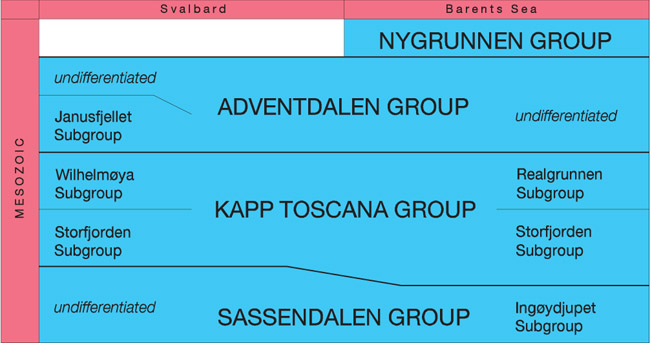
3. MESOZOIC LITHOSTRATIGRAPHY

ATLE MØRK, WINFRIED K. DALLMANN, HENNING DYPVIK, ERIK P. JOHANNESSEN, GEIR BIRGER LARSSEN, JENØ NAGY, ARVID NØTTVEDT, SNORRE OLAUSSEN, TATJANA M. PČELINA & DAVID WORSLEY


3.1 Stratigraphic development of Svalbard and the Barents Sea Shelf
  3.2 General subdivision
  3.3 Previous stratigraphic schemes
  3.4 Regional descriptions and major revisions
     3.4.1 Sassendalen Group
     3.4.2 Kapp Toscana Group
     3.4.3 Adventdalen Group
     3.4.4 Nygrunnen Group
     3.4.5 Intrusive rocks
  3.5 Lexicon of lithostratigraphic units
  3.6 Abandoned lithostratigraphic unit names


3.1 Stratigraphic development of Svalbard and the Barents Sea Shelf

The chapter on Mesozoic stratigraphy of Svalbard also comprises the offshore deposits of the western Barents Sea Shelf, although offshore deposits are not included in the discussions of the Upper Palaeozoic and Cenozoic of Svalbard. The present knowledge of the essentially continuous stratigraphy and spatial relations of the Mesozoic succession of the entire Barents Sea Shelf supports the establishment of a common stratigraphic framework. The offshore units are included in the lexicon text (
Chapter 3.5) and in the Correlation scheme (Fig. 3-05
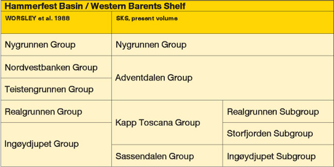
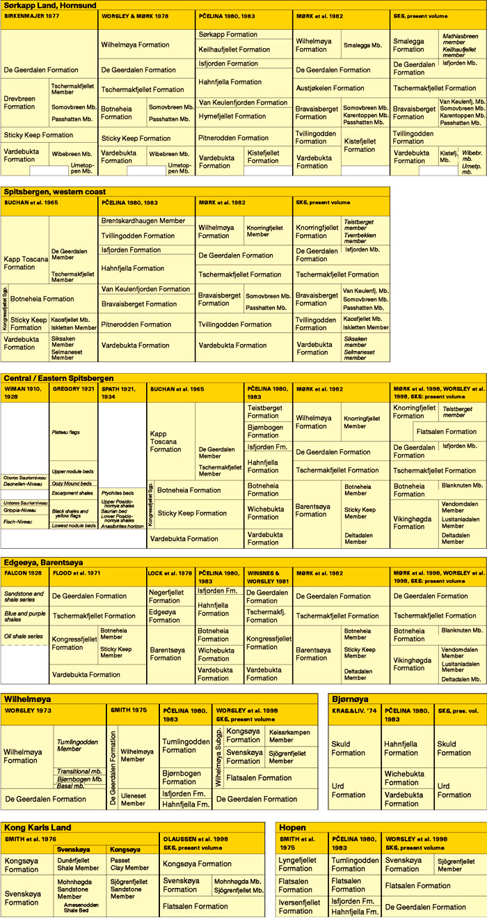
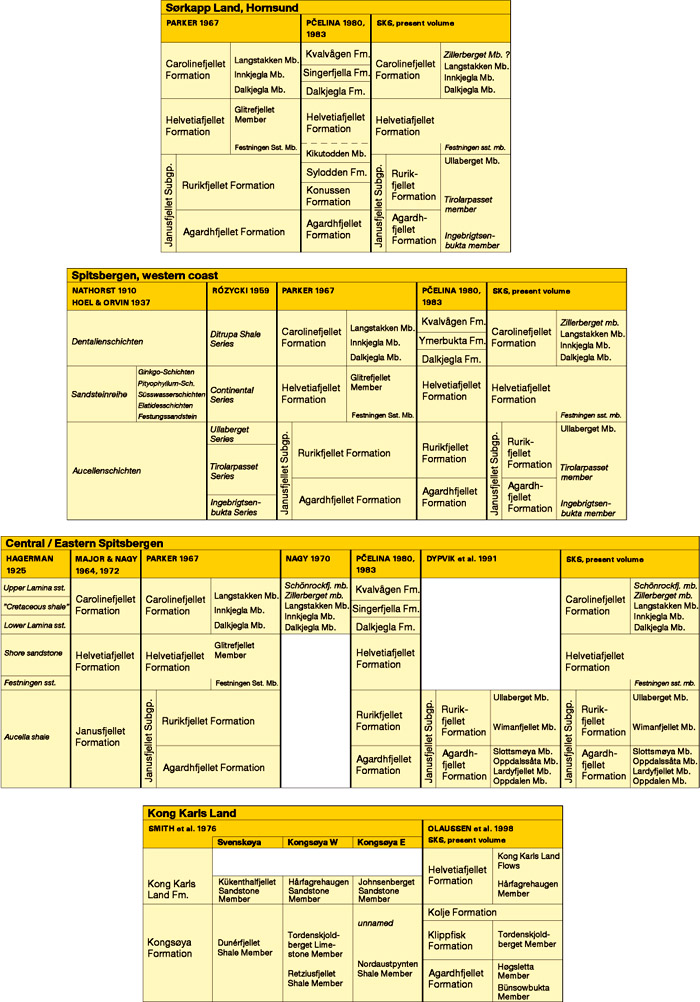
), but are not represented by maps and type sections. The reader is referred to the cited publications on the Barents Sea Shelf.
The Barents Sea Shelf, with Svalbard forming its exposed northwestern corner, was an area of clastic deposition during the entire Mesozoic. While carbonate sedimentation had prevailed from the late Carboniferous into the Permian, the late Permian had seen a transition to cherty/spiculitic mudstone deposition in basinal areas and interbedded bioclastic limestones and shales in platform settings. An extensive late Permian hiatus, seems to have developed everywhere. This hiatus was submarine in basinal areas, while marginal areas were exposed and locally not transgressed before the late Early Triassic. Major sedimentary basins were developed over the main Svalbard islands, the Bjørnøya Basin, Hammerfest Basin and Nordkapp Basin of the Western Barents Sea Shelf and the Central Barents Sea Depression west of Novaja Zemlja (Fig. 1-02). These basins were separated by shallow shelf or platform areas, surrounding land areas or local highs. An extensive seaway connected these basins – and other basins southward to the North Sea area – during most of the Mesozoic, and deltaic and coastal sediments prograded into the sea from different land areas, creating a complex pattern of sedimentary units. Erosion and redeposition of the clastic sediments was important during long periods.
During most of the Mesozoic, the main land and sedimentary provenance area for the successions deposited in Svalbard was situated to the west of Svalbard (eastern North Greenland), from where most sediment bodies built out into the easterly basin. An additional northern to northeastern source area became evident from the Late Triassic (Steel & Worsley 1984), and at Kong Karls Land also from north and east (Olaussen et al., in prep.). All Mesozoic sedimentary episodes led to sedimentation across all of Svalbard, possibly except northernmost areas, where the record is lacking, both due to the periodical absence of sedimentation and to later stripping off of sediments.
In the Barents Sea, a complete stratigraphic nomenclature is only established for the Hammerfest Basin, while in other areas only a few units are defined at present.

Back on top

3.2 General subdivision

Traditionally, three lithostratigraphic groups have been defined in the Mesozoic succession of Svalbard (Sassendalen, Kapp Toscana and Adventdalen groups: Buchan et al. 1965; Parker 1967) and five in the southwestern Barents Sea (Ingøydjupet, Realgrunnen, Teistengrunnen, Nordvestbanken and Nygrunnen groups: Worsley et al. 1988;
Fig. 3-02). In the present proposal, those Barents Sea Shelf groups that have equivalents on land apply the group names defined on land. For the Triassic to Middle Jurassic of the Barents Sea Shelf, the previous subdivision is taken care of by converting previous groups into subgroups (Fig. 3-01). One group (Nygrunnen Group) was only deposited on the Barents Sea Shelf when Svalbard was uplifted at the end of the Mesozoic.
The Sassendalen Group was defined on Spitsbergen by Buchan et al. (1965) and comprises shales, siltstones and sandstones of Early and Middle Triassic age. The group's coastal to deltaic sediments exposed on western Spitsbergen grade into organic-rich shelf mudstones eastwards in Svalbard and southwards into the Barents Sea Shelf, however, a thick marine to coastal clastic succession is deposited in the Hammerfest Basin (southwestern Barents Sea Shelf). Worsley et al. (1988) defined the "Ingøydjupet Group" in the Hammerfest Basin for the Induan to Anisian shales and claystones grading upwards into Ladinian and Carnian compositionally immature sandstones. In the present nomenclature, the name Ingøydjupet Subgroup is reserved for the finer-grained Induan - Anisian succession of the Barents Sea Shelf. The subgroup is correlated with and included in the Sassendalen Group. The Ladinian – Carnian sandstonerich succession is correlated with and included in the overlying Kapp Toscana Group.
The Kapp Toscana Group, originally defined by Buchan et al. (1965) as a formation, comprises sandstones and mudstones of late Middle Triassic to Middle Jurassic age. The group represents a significant change in sedimentary regime from the underlying groups, and a turn into similar shallow marine to deltaic depositional environments across the entire Barents Sea Shelf.
The Storfjorden Subgroup (new name) comprises the compositionally immature sandstones and mudstones of late Middle (Ladinian) and early Late Triassic age deposited in coastal to shallow marine environments. The subgroup comprises the lower part of the Kapp Toscana Group, including the upper, compositionally immature part of the "Ingøydjupet Group" on the southwestern Barents Sea Shelf as defined by Worsley et al. (1988).


The Wilhelmøya Subgroup corresponds to the "Wilhelmøya Formation" (Worsley 1973; Bjærke & Dypvik 1977; Edwards et al. 1979) in the Svalbard area. The variedly condensed development in different areas of Svalbard led to the establishment of several formations within the succession and the change of the Wilhelmøya unit from formation to subgroup rank. The subgroup consists of texturally mature sandstones deposited on coastal plains and in deltaic through shallow marine environment; it shows an increasingly condensed development towards the west.
The Realgrunnen Subgroup was defined with group rank by Worsley et al. (1988) in the Hammerfest Basin. The recent understanding of the intermediate nature of the coeval deposits of Kong Karls Land, and data from numerous cored wells in the Barents Sea, correlate this succession with its condensed counterpart in Svalbard, the Wilhelmøya Subgroup and makes it appropriate to include the succession in the Kapp Toscana Group.
The Adventdalen Group was defined on Spitsbergen by Parker (1967) for the shales and minor sandstone successions of latest Middle Jurassic to Early Cretaceous age. The group is here laterally extended to include correlative sediments on Kong Karls Land and in the southwestern Barents Sea, previously referred to as the "Teistengrunnen" and "Nordvestbanken groups" (Worsley et al. 1988). Dark organic-rich shales of Late Jurassic age occur throughout the area. A hiatus of varying magnitude above these shales reflects a period of tectonic disturbance at the Jurassic - Cretaceous transition, well established in the Barents Sea. This is followed by calcareous sedimentation on platform areas and dark, but organic-lean, shales in the basins. In the north, in Svalbard, deltaic sedimentation gave rise to the deposition of prominent sandstone bodies.
The Janusfjellet Subgroup (Parker 1967) comprises the dark shale succession of latest Middle Jurassic to Hauterivian age in Svalbard.
The Nygrunnen Group (Worsley et al. 1988) is only documented in the southern part of the Barents Sea and comprises a basinal, shaley development, with condensed calcareous sandstones in platform setting. The group is of Late Cretaceous age.

Back on top

3.3 Previous stratigraphic schemes

Most authors who have elaborated previous stratigraphic schemes for Svalbard worked either on the Triassic to Middle Jurassic (Sassendalen and Kapp Toscana groups;
Fig. 3-03), or the Middle Jurassic to Early Cretaceous (Adventdalen Group; Fig. 3-04). This was a natural consequence of the major sequence boundary between these two groups which also is reflected in the quite different lithologies below and above. Exceptions are Pčelina (1980, 1983), presenting results of the Russian research on the archipelago, and stratigraphers working on some of the eastern islands (Worsley 1973; Smith 1975; Smith et al. 1975, 1976).
The Triassic to Middle Jurassic of Svalbard has historically often been referred to as the Triassic only, due to the fact that the Jurassic represents a very condensed succession in the best accessible (western and central) parts of Svalbard, often only a few metres thick. This changed with the recognition of the much thicker Jurassic sections on Wilhelmøya (Worsley 1973; Smith 1975), Hopen (Smith et al. 1975) and Kong Karls Land (Smith et al. 1976).
The "Triassic" stratigraphy was first summarised into a common scheme by Buchan et al. (1965) which was widely applied until the early 1980s. Several local adjustments were then made (Flood et al., 1971, and Lock et al. 1978, on Edgeøya and Barentsøya; Worsley & Mørk, 1978, in southern Spitsbergen), until Mørk et al. (1982) summarised the revised view into a new scheme, this time paying attention to the differential stratigraphic development on western and central/eastern Spitsbergen.
The "Jurassic-Cretaceous" stratigraphy was firstly summarised into a common scheme by Parker (1967). Minor adjustments or supplements for individual regions were made by Norwegian and British authors (Nagy 1970; Smith et al. 1976). A detailed subdivision of the Janusfjellet Subgroup in central and eastern Spitsbergen was presented by Dypvik et al. (1991).
More or less simultaneously with Mørk et al. (1982), a different stratigraphic nomenclature was developed by Pčelina (1980, 1983), also reflecting the regionally varying stratigraphic development, but showing a greater influence of chronostratigraphic thinking, i.e. a trend to summarise lithologies into formations (Russian: svity, lit. transl. "suites") according to their related stage.
A major effort was undertaken by the Stratigraphic Committee of Svalbard in the context of the present compilation to elaborate a synthesis of the Russian and Norwegian schemes, while maintaining as many names as possible shown on published maps without major redefinitions, and at the same time taking care of as many as possible priorities by first publication. This resulted, of course, in a number of compromises. Still, the revised scheme (Fig. 3-05) has preserved the traditional group subdivision and most formation names familiar from published maps. At the same time, it takes into account important stratigraphic units and correlations from the Russian scheme represented by Pčelina (1980, 1983), though this is not always reflected by the names themselves (for account of choice of names: see chapters 3.4, 3.5 and 3.6.1).
Historic priority is the main criterion for recognition and acceptance of lithological unit names, however, many terms have been poorly defined in the past or have first been mentioned in areas where they are poorly exposed or developed. Several units have been emended or redefined to adjust the stratigraphic framework to the meanwhile improved knowledge level, or to enable correlations between these areas and the Barents Sea Shelf. The present synthesis also tries to incorporate regional variations, often by redefining type sections (stratotypes), or by defining reference sections (hypostratotypes) in addition to the type sections, or by accepting locally or regionally developed subdivisions at member level.


Back on top

3.4 Regional descriptions and major revisions

3.4.1 Sassendalen Group
The Sassendalen Group is maintained as originally defined by Buchan et al. (1965) on central Spitsbergen. The major revision is the lateral extension of the group to include the Ingøydjupet Subgroup of the Barents Sea.
In Svalbard (except Bjørnøya) the subdivision of the group into three units has been applied in all previous stratigraphic work, although with different hierarchies and regional implications. The lower unit is characterised by shallow marine to coastal silt- and sandstones, the middle unit by upward coarsening shale-siltstone/sandstone sequences, and the upper unit by phosphatic, organic-rich shales and subordinate sandstones.
Buchan et al. (1965) defined three formations within this group, the Vardebukta Formation, "Sticky Keep Formation" and Botneheia Formation, of which the two upper units formed the "Kongressfjellet Subgroup". The latter was changed to formation rank by Flood et al. (1971), but this was only applied on the map sheet Adventdalen (Major & Nagy 1964,1972), and has been rejected by subsequent authors. This rejection may have been a consequence of the problems arising when defining the lower boundary of this unit.
From the 1970s onward, separate subdivisions were introduced for central/eastern and western Svalbard, due to the different facies development in both areas. The two developments are thought to have a transition at depth below the younger fill of the Central Cenozoic Basin, with a proximal, coarse-grained facies to the west, and a more distal, shaledominated facies to the east.
The suggested member subdivision of the Sassendalen Group's formations in Svalbard (Fig. 3-05) is a synthesis of the units of Buchan et al. (1965), Birkenmajer (1977), Mørk et al. (1982) and Pčelina (1983), some of them with a revised rank. A few members, from all of these authors, may be subjected to further refinements after more thorough fieldwork. These units are provisionally maintained with an informal status (Fig. 3-05).

Central and eastern areas:
Lock et al. (1978) included all shales of Early and Middle Triassic age on the islands Barentsøya and Edgeøya in the "Barentsøya Formation", with the organic-rich dark shales (previously named Botneheia Formation) distinguished as the "Oil Shales Member". For central and eastern Spitsbergen, Mørk et al. (1982) kept the terminology of Lock et al. (1978), but retained the three previously defined formations of Buchan et al. (1965) at member level. Pčelina (1983) also retained a tripartite subdivision of the Lower and Middle Triassic, and introduced the new name "Wichebukta Formation" for the upper Lower Triassic (Olenekian) of eastern Svalbard, while restricting the Botneheia Formation to the organic-rich shale lithologies in central and eastern Spitsbergen, Barentsøya and Edgeøya.
As indicated above, there were difficulties in recognising the boundary between the two lower subunits of the group (Deltadalen and "Sticky Keep" members) in central Spitsbergen. This may be due to the circumstance that there is another similar, distinct lithological boundary within the "Sticky Keep Member". Even the best available regional survey, Major & Nagy's (1964) map sheet Adventdalen has – in many places – mixed up the base of the "Sticky Keep Member" (base of "Kongressfjellet Formation") with the other boundary (Mørk et al. 1999).
The two lower units, consequently, are here assigned to only one formation, the Vikinghøgda Formation, with its type section at Vikinghøgda (Mørk et al. 1999), a mountain separated from the neighbouring mountain Sticky Keep by the valley Deltadalen, i.e. in the traditional type area for several of the units (Buchan et al. 1965; Mørk et al. 1982). To avoid redefinitions and to facilitate boundary recognitions in the field, a threefold subdivision of the Vikinghøgda Formation is proposed. These three units are the Deltadalen Member (unchanged definition), Lusitaniadalen Member and Vendomdalen Member, the latter two replacing the "Sticky Keep Member". All member names are now from tributary valleys of the major valley Sassendalen in the type area.

Western Spitsbergen:
Along western Spitsbergen, the threefold subdivision of Buchan et al. (1965) is retained, with the Vardebukta Formation (Induan; Buchan et al. 1965) at its base, followed by the Tvillingodden Formation (Olenekian) and the Bravaisberget Formation (Anisian and Ladinian) (Mørk et al. 1982). This subdivision is also followed by Pčelina (1983) although she used a different name for the middle unit ("Pitnerodden Formation").

Bjørnøya and Barents Sea:
The coeval units of the southwestern Barents Sea, the Havert, Klappmyss and Kobbe formations (Worsley et al. 1988) are summarised in the Ingøydjupet Subgroup. It is defined in the Hammerfest Basin and contains shales and sandstones of Early and partially Middle Triassic age (Ingøydjupet "Group" of Worsley et al. 1988). With the southward extension of the Kapp Toscana Group into the Barents Sea and the incorporation of the Snadd Formation into the latter, the Ingøydjupet Subgroup is restricted to the southwestern Barents Sea.
The Steinkobbe Formation (Mørk & Elvebakk 1999), overlying rocks of the Ingøydjupet Subgroup on the Loppa High, shows more similarities with its time-equivalents in Svalbard.
The Sassendalen Group also includes the coeval deposits on Bjørnøya, the Urd Formation Krasil'ščikov & Livšic 1974; Mørk et al. 1982).


3.4.2 Kapp Toscana Group
The Kapp Toscana Group was defined in Svalbard by Buchan et al. (1965) with formation rank, and later modified by the inclusion of the Wilhelmøya "Formation" (Mørk et al. 1982), after the recognition of the latter in eastern Svalbard (Worsley 1973) and subsequent tracing of its equivalents throughout Spitsbergen. Due to a threefold subdivision into successions of common characteristics, the Kapp Toscana Group is subdivided into subgroups.
The Storfjorden Subgroup (established here) comprises shallow marine and coastal deposits of compositionally immature sandstones and claystones that can be traced across major parts of Svalbard, including Hopen (Tschermakfjellet Formation and De Geerdalen Formation; Buchan et al. 1965; Harland et al. 1974), and into the Barents Sea (Snadd Formation; Worsley et al. 1988). The immature sandstones of the Skuld Formation (Mørk et al. 1982, 1990; name proposed by Krasil'ščikov & Livšic, 1974) on Bjørnøya are also included here. The subgroup is of late Middle Triassic (Ladinian) to Late Triassic (Norian) age.
The Realgrunnen Subgroup (Worsley et al. 1988) is most completely developed in the southwestern Barents Sea where it consists of mature sandstones deposited in coastal plain and deltaic through shallow marine environments. The Realgrunnen "Group" was defined in the Hammerfest Basin as comprising four sandstone formations (Fruholmen, Tubåen, Nordmela and Stø; Worsley et al. 1988). The close lithological similarities between the Hammerfest Basin and Kong Karls Land were first described by Johannessen & Embry (1989), and further elaborated since (Olaussen et al., in prep.).
The Wilhelmøya Subgroup (Wilhelmøya "Formation"; Worsley 1973) which occurs in large parts of Svalbard represents the condensed, marine equivalents of the Realgrunnen Subgroup. The inclusion of the Late Triassic to Middle Jurassic units of Kong Karls Land into the Wilhelmøya "Formation" as suggested by Edwards et al. (1979) further demonstrated the similar development of sandstone facies across both Svalbard and the western Barents Sea. Correlations are, however, hampered by the numerous and extensive hiati, and by the poor biostratigraphic resolution in the condensed Wilhelmøya Subgroup, especially as it occurs on central Spitsbergen (Knorringfjellet Formation) and southern Spitsbergen (Smalegga Formation).
The late Triassic (Norian) to latest Middle Jurassic (Bathonian) lithostratigraphy of Svalbard is rather complex, with more than 20 lithostratigraphic units recognised within it during the past 20 years. On Wilhelmøya, Kong Karls Land and Hopen, different nomenclatures were introduced (Smith 1975; Smith et al. 1975, 1976). Newly improved regional understanding has allowed integration of these units within the Wilhelmøya Subgroup (Olaussen et al., in prep.) and the resultant reduction of the number of unit names in eastern Svalbard (Flatsalen, Svenskøya and Kongsøya formations). The lack of suitable place names on these islands made a redefinition of several of Smith's et al. (1976) formation and member names necessary (Olaussen et al., in prep.; for individual names see Chapter 3.6.1). The transitional nature of the Kong Karls Land succession between the remaining part of Svalbard and the Barents Sea Shelf is the key for the correlation across this long distance. Seismic interpretation indicates that the group also is present in the subsurface between the exposed and drilled areas (Olaussen et al., in prep.).
The stratigraphic interval including the upper part of the Wilhelmøya Subgroup and the lower part of the Adventdalen Group is formed by the Brentskardhaugen Bed (Parker 1967) and locally the overlying Marhøgda Bed (Bäckström & Nagy 1985). The Brentskardhaugen Bed is a thin conglomeratic unit rich in phosphatic nodules with fossils of different ages that document an underlying unconformity representing a hiatus. The bed has been interpreted by several authors, mainly working in central Spitsbergen (Birkenmajer 1972a, 1975, 1980; Birkenmajer & Pugaczewska 1975; Birkenmajer et al. 1982; Bäckström & Nagy 1985; Dypvik et al. 1985; Dypvik et al. 1991) as a remanié deposit and placed at the base of the Janusfjellet Subgroup (Agardhfjellet Formation). The Wilhelmøya Subgroup outside central Spitsbergen contains several phosphatic nodular beds, and at least two hiati on Wilhelmøya and in Sørkapp Land, which by several other authors is interpreted to support the integrated nature of the Brentskardhaugen Bed within the condensed succession of the Wilhelmøya Subgroup (Parker 1967; Worsley 1973; Worsley & Mørk 1978; Pčelina 1980; Mørk et al. 1982; Maher 1989; Krajewski 1992; Olaussen et al., in prep.). The overlying, oolitic Marhøgda Bed seems to show a close genetic relation to the Brentskardhaugen Bed. Another hiatus above the Marhøgda Bed is suggested by Pčelina (1980) and Kopik & Wierzbowski (1988). The Brentskardhaugen and Marhøgda beds thus are interpreted to occupy either a stratigraphic position at the top of the condensed shallow-marine succession of the Wilhelmøya Subgroup, or at the base of the renewed development of a basin, where the sediments of the Adventdalen Group were deposited. In the present scheme (Fig. 3-05) and the type sections (Chapter 3.5), the beds are included in the Wilhelmøya Subgroup due of to their lithological affiliation, regardless of their diverging genetical interpretations.

click
Fig. 3-05: Proposed lithostratigraphic scheme for the Mesozoic of Svalbard and the Barents Sea Shelf.


3.4.3 Adventdalen Group
The Adventdalen Group was defined on central Spitsbergen by Parker (1967), extended to include correlative units on Kong Karls Land by Smith et al. (1976), and is herein further extended to comprise both the "Teistengrunnen" and "Nordvestbanken groups" as defined by Worsley et al. (1988) in the Hammerfest Basin.
The group consists of claystones, shales and sandstones deposited in shelf settings of latest Middle Jurassic and Early Cretaceous age. Important hydrocarbon source rocks occur in the upper Jurassic succession both in Svalbard (Agardhfjellet Formation) and in the Barents Sea (Hekkingen and Fuglen Formations). A significant sandstone unit, the Helvetiafjellet Formation, in the middle of the group in Svalbard is the result of regional uplift, relative sea level fall and deltaic progradation (Gjelberg & Steel 1995), while in platform settings in the Barents Sea, a condensed limestone interval developed in the earliest Cretaceous (Klippfisk Formation, Smelror et al. 1998) which grades into marls and calcareous claystones in the basins. A hiatus occurs around the Jurassic - Cretaceous boundary. In the Barents Sea this is separating the Kimmerian disturbed sediments (Gabrielsen et al. 1990) from Cretaceous calcareous shales, while in central and eastern Spitsbergen this hiatus is associated with the Myklegardfjellet Bed (Birkenmajer 1980), a complex, plastic claystone marker unit. Tectonic disturbances have obscured this boundary at many localities on western and southern Spitsbergen.
The Janusfjellet Subgroup (Parker 1967; Dypvik et al. 1991) was established in central and eastern Spitsbergen as comprising the Agardhfjellet Formation (Jurassic) and Rurikfjellet Formation (Cretaceous). Dypvik et al. (1991) defined seven members in these areas. In southern Spitsbergen (i.e. mainly in Torell Land), Birkenmajer (1975) followed Różycki's (1959) definition of three members within their Janusfjellet "Formation". The lower and upper members show a clear parallel development in central Spitsbergen, while the middle member spans the Jurassic - Cretaceous boundary. Reconnaissance studies in the summer of 1996 (A. Mørk, H. Dypvik, and others) reconfirmed previous notes (Dallmann et al. 1990, 1993) that the subgroup is affected by tectonics and the previously assigned lithostratigraphy and sequence thickness should be treated with care. Consequently, the Janusfjellet Subgroup applies to all of Spitsbergen, although it should be recognised that the boundary between the Agardhfjellet and Rurikfjellet formations may be difficult to trace in western Spitsbergen. However, major parts of the sediments can easily be referred to either unit. The present extension of the use of the name Janusfjellet Subgroup to all exposure areas of Svalbard also implies that coeval sediments on Wilhelmøya and Kong Karls Land ("Retziusfjellet Shale Member" and parts of "Dunérfjellet" and "Nordaustpynten Shale members", Smith 1976) are included in the Agardhfjellet Formation.
The Fuglen Formation is retained as defined by Worsley et al. (1988) in the Hammerfest Basin, where dark, pyritic mudstones with limestone interbeds dominate, while it has a more proximal, highly bioturbated sandy development towards the south. Thin correlative units further north in the Barents Sea are also present (data from Norwegian Petroleum Directorate/IKU Petroleum Research). The Fuglen Formation is unconformably separated by a hiatus from the underlying Stø Formation, and the boundary youngs northwards. The Hekkingen Formation consists of the dark organicrich claystones with a pronounced gamma peak and a very high organic content in the lower Alge Member, overlain by the Krill Member that also is a good hydrocarbon source rock (Worsley et al. 1988). The formation is defined in the Hammerfest Basin, but extends over a large part of the Barents Sea (i.e. well documented on the Bjarmeland Platform; Leith et al. 1993) where it is one of the most important hydrocarbon source rocks. The basal hiatus has different durations in different areas.
On the Barents Sea Shelf, a major break in deposition took place at the Jurassic - Cretaceous boundary, associated with the Late Kimmerian tectonic movements. When deposition resumed in the early Cretaceous, dark grey to greyish brown claystones of the Knurr Formation were deposited in the Hammerfest Basin (Worsley et al. 1988), while a condensed marl and limestone succession is developed in platform areas and is assigned to the Klippfisk Formation (Smelror et al. 1998). On the Bjarmeland Platform several shallow cores penetrate the unit which here is assigned to the Kutling Member (Smelror et al. 1998), while similar sediments on Kong Karls Land, although poorly exposed, are assigned to the Tordenskjoldberget Member (Smith et al. 1976).
Following the episode of carbonate deposition, basinal conditions again developed over major parts of the southwestern Barents Sea with deposition of dark brown to grey shales and claystones with interbeds of pale limestone and dolomite. These sediments are defined as the Kolje Formation in the Hammerfest Basin (Worsley et al. 1988). The unit can also be traced over larger areas and is well developed on the Bjarmeland Platform. A thin wedge of shales of this formation has recently been recognised on Kong Karls Land (Smelror et al. 1998).
The Helvetiafjellet Formation with its lower sandstones (Festningen sandstone member) and overlying deltaic shalesandstone development (Gjelberg & Steel 1995) was defined by Parker (1967) on Spitsbergen. This unit is here extended to include the sandstones of Kong Karls Land, singled out as the Hårfagrehaugen Member (Smith et al. 1976, Olaussen et al., in prep.). Basalts intercalated with and overlying the upper part of the Hårfagrehaugen member are referred to as the Kong Karls Land Flows.
The youngest Mesozoic sediments of Svalbard are the shales and sandstones of the Carolinefjellet Formation (Parker 1967). Only the two lower subunits, the Dalkjegla and Innkjegla members, are preserved in central Spitsbergen due to late Mesozoic and Cenozoic uplift and erosion, but the unit is most completely developed in southeastern Spitsbergen where three additional subunits (Langstakken, Zillerberget and Schönrockfjellet members) are preserved (Nagy 1970; Dallmann et al. 1994).
In the Barents Sea Shelf a dark grey to green claystone unit (Kolmule Formation), correlative to the Carolinefjellet Formation, is defined in the Hammerfest Basin (Worsley et al. 1988), but extends over wider areas as documented on the Bjarmeland Platform (Århus 1991; Leith et al. 1993).

3.4.4 Nygrunnen Group
Late Cretaceous sediments are only preserved on the Barents Sea Shelf, where they form the Nygrunnen Group (Worsley et al. 1988). The thick basinal development in the Hammerfest Basin is assigned to the Kveite Formation and consists of a more than 1 km thick succession of greenish to grey claystones. Its thinly developed platform equivalent, the Kviting Formation, consists of calcareous sandstones and claystones. A major unconformity is assumed below the group.

3.4.5 Intrusive rocks
The name Diabasodden Suite is proposed for the dolerite sills and dikes of latest Jurassic to Early Cretaceous age that intruded older rocks all across Svalbard.


Back on top