|
[ Janusfjellet Subgroup | Agardhfjellet Formation | Rurikfjellet Formation | Fuglen Formation ]
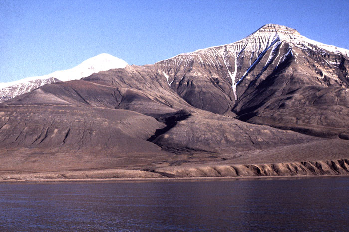
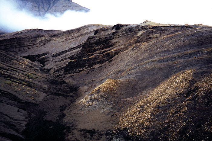
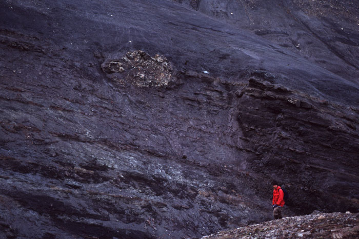
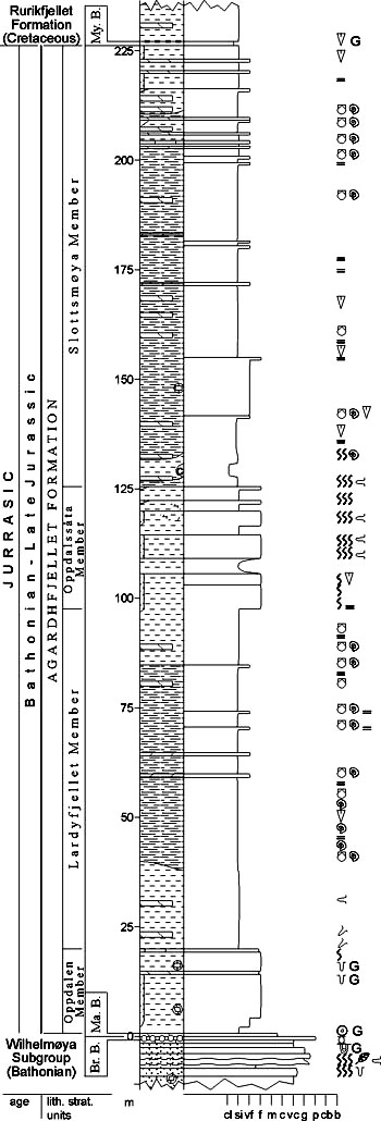
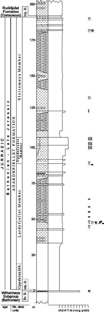
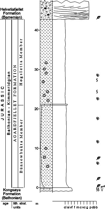
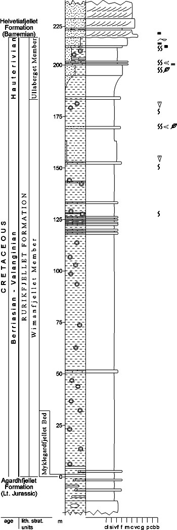
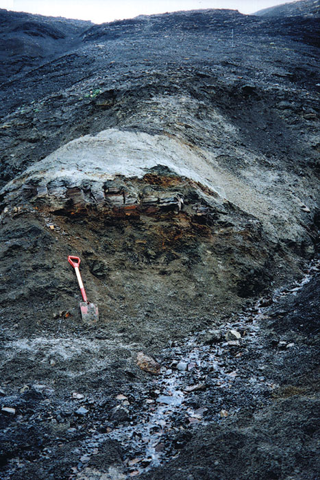
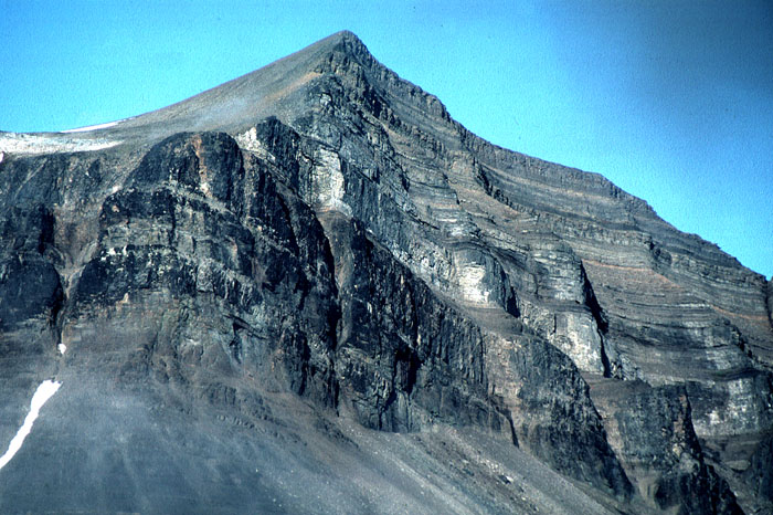
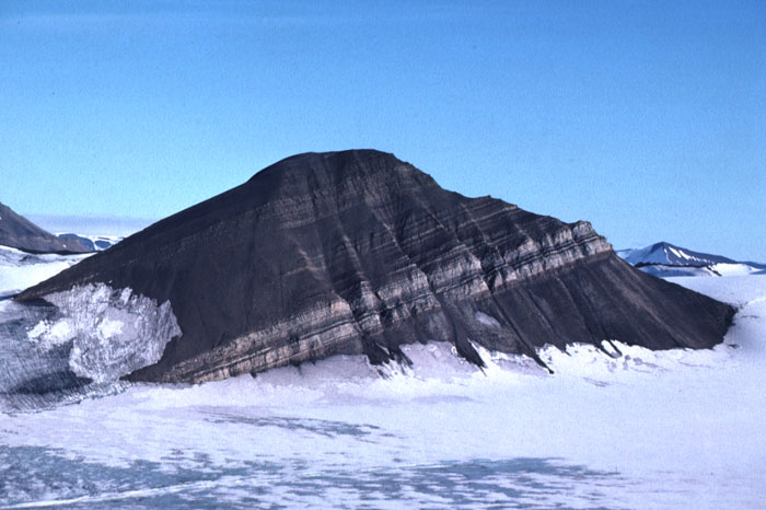
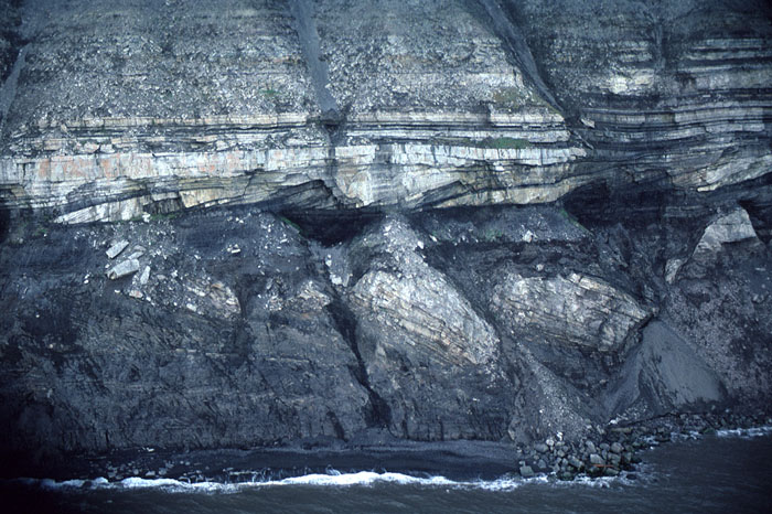
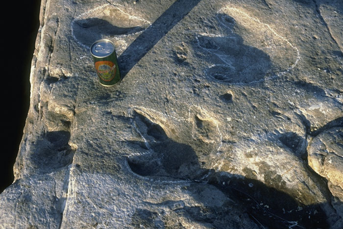
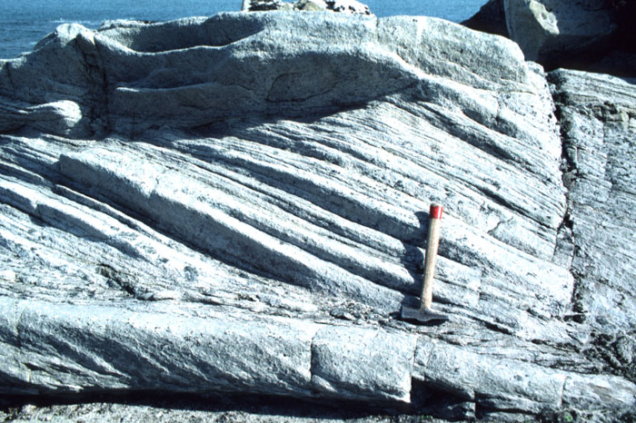
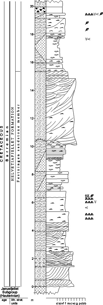
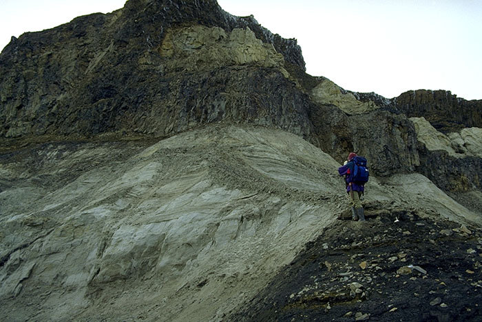
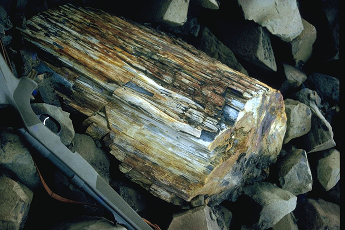
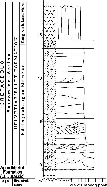
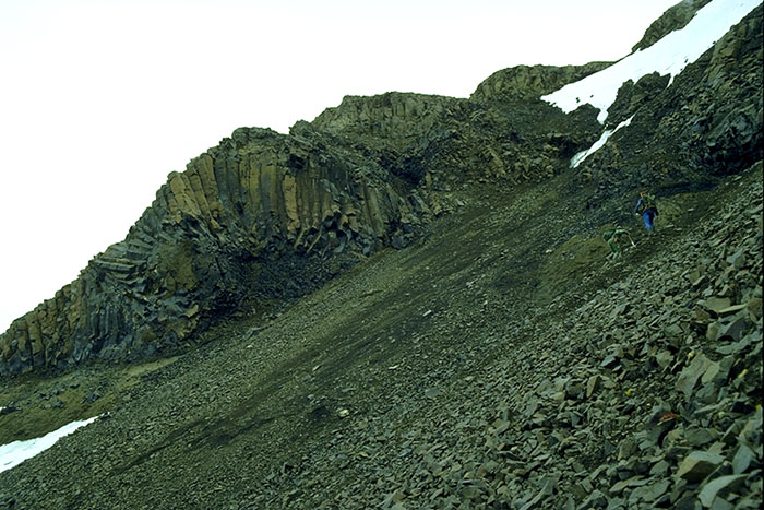
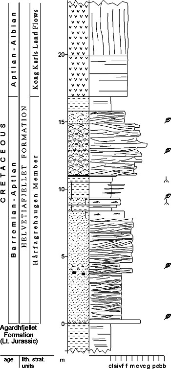
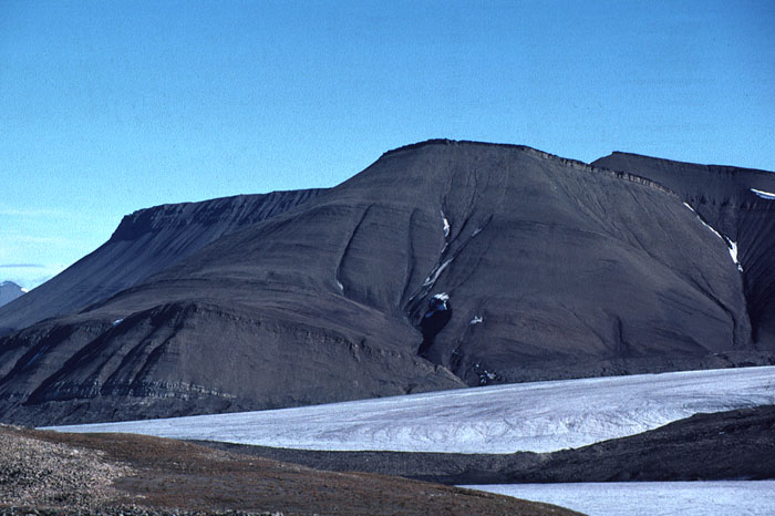
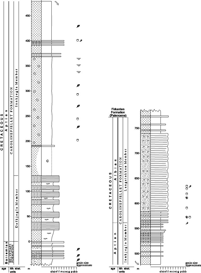
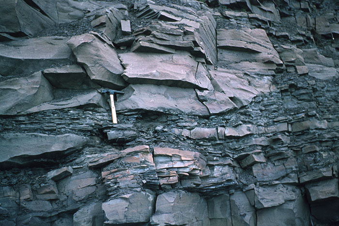
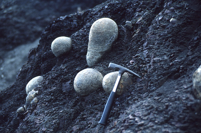
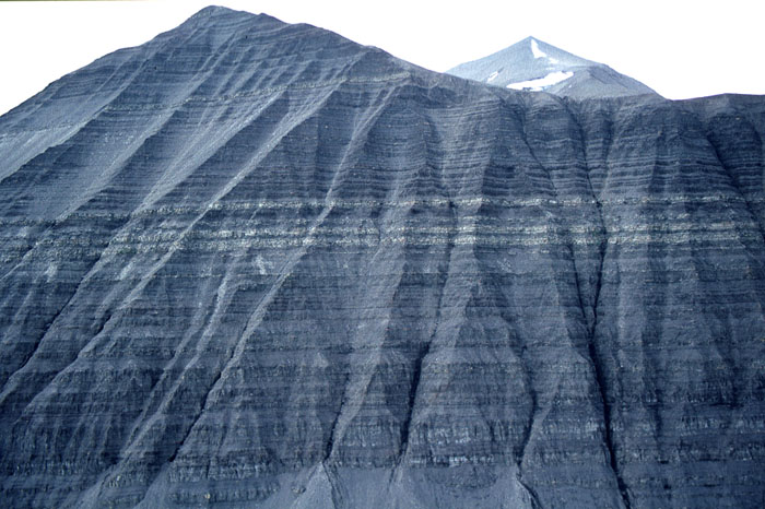
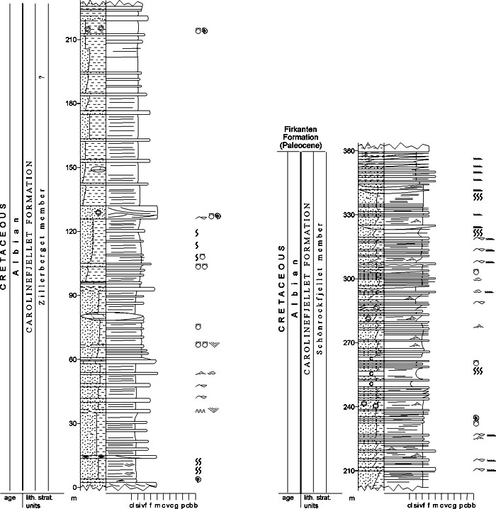
[ Hekkingen Formation | Knurr Formation | Klippfisk Formation | Kolje Formation ] [ Helvetiafjellet Formation | Carolinefjellet Formation | Kolmule Formation ] ADVENTDALEN GROUP (M-64) 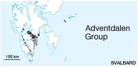 STATUS OF UNIT: Formal FIRST USE OF NAME: Parker 1967 CURRENT DEFINITION: Parker 1967; extended to Kong Karls Land by Smith et al. 1976; here extended to comprise coeval deposits on the Barents Sea Shelf SYNONYM(S) AND REFERENCE(S): None ORIGIN OF NAME: Adventdalen: A major valley in central Spitsbergen TYPE AREA: Central Spitsbergen STRUCTURAL SETTING: Barents Sea Shelf (including Svalbard) DEPOSITIONAL AGE: Late Jurassic - Early Cretaceous OVERLYING UNIT(S): Van Mijenfjorden Group (Svalbard), Nygrunnen Group (Barents Sea Shelf) UNDERLYING UNIT(S): Kapp Toscana Group SUPERIOR UNIT: None OTHER USE OF NAME: None THICKNESS: Thickness on Svalbard: ca. 750-1600 m, known thickness on Barents Sea Shelf: ca. 1000-1750 m MAIN LITHOLOGIES: Shale, siltstone, sandstone DESCRIPTION: The Adventdalen Group comprises shales, siltstones and sandstones of Late Jurassic to Early Cretaceous age in Svalbard and throughout the Barents Sea Shelf (Figs. 3-67, 3-68, 3-69). JANUSFJELLET SUBGROUP (M-65) 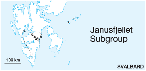 STATUS OF UNIT: Formal FIRST USE OF NAME: Parker 1967 CURRENT DEFINITION: Dypvik et al. 1991 SYNONYM(S) AND REFERENCE(S): None ORIGIN OF NAME: Janusfjellet: A mountain in northern Nordenskiöld Land TYPE SECTION (Fig. 3-70): Agardhfjellet, Sabine Land STRUCTURAL SETTING: Barents Sea Shelf (including Svalbard) DEPOSITIONAL AGE: Late Jurassic - Early Barremian OVERLYING UNIT(S): Helvetiafjellet and Klippfisk formations UNDERLYING UNIT(S): Kapp Toscana Group SUPERIOR UNIT: Adventdalen Group OTHER USE OF NAME: None THICKNESS: Ca. 750 m in Sørkapp Land, 550-700 m on western Spitsbergen, 280-420 m on eastern Spitsbergen (418 m in the stratotype) MAIN LITHOLOGIES: Shale, siltstone, sandstone DESCRIPTION: The Janusfjellet Subgroup is defined in the Svalbard area, where it mainly consists of bituminous black shales and siltstones that pass into sandstones uppermost in the unit (Fig. 3-67). The subgroup comprises the Agardhfjellet and Rurikfjellet formations. A common name for these two formations is appropriate, because the distinction is difficult or impossible in many tectonised areas on western Spitsbergen, while the subgroup is an easily mappable unit. For this reason, it has often been referred to as the Janusfjellet "Formation" in previous geological literature. The subgroup is of marine shelf origin. AGARDHFJELLET FORMATION (M-66) 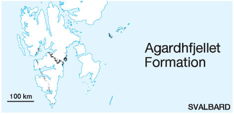 DISTRIBUTION shown on figs.: 3-06, 3-07, 3-08, 3-09, 3-10, 3-11, 3-12 (partly within 'Janusfjellet Subgroup, undifferentiated') STATUS OF UNIT: Formal FIRST USE OF NAME: Parker 1967 CURRENT DEFINITION: Parker 1967 SYNONYM(S) AND REFERENCE(S): "Aucellenschichten": Nathorst 1910 ORIGIN OF NAME: Agardhfjellet: A mountain in Sabine Land, Agardhbukta TYPE SECTION (Figs. 3-70, 3-71): Stratotype: Agardhfjellet, eastern Sabine Land Hypostratotype: Oppdalssåta, western Sabine Land DEPOSITIONAL AGE: Late Jurassic DATING METHODS AND REFERENCE(S) FOR AGE: Macrofossils (e.g. ammonites): Frebold 1928; Różycki 1959; Parker 1967; Birkenmajer & Pugaczewska 1975; Pčelina 1980; Birkenmajer et al. 1982; Eršova 1983; Birkenmajer & Wierzbowski 1991. Foraminifera: Løfaldli & Nagy 1980; Nagy et al. 1988, 1990. Palynology: Løfaldli & Thusu 1976; Bjærke 1978 OVERLYING UNIT(S): Rurikfjellet Formation UNDERLYING UNIT(S): Wilhelmøya Subgroup SUPERIOR UNIT: Janusfjellet Subgroup OTHER USE OF NAME: None THICKNESS: 90-350 m, 242 m in the stratotype MAIN LITHOLOGIES: Black shale, siltstone LOWER BOUNDARY DEFINITION: The lower boundary is defined at the boundary between the underlying oolitic Marhøgda Bed or, where absent, the nodular Brentskardhaugen Bed, and an overlying fining-upward succession of poorly sorted sandstones and siltstones. DESCRIPTION: A fining upwards succession of poorly sorted, clay-rich fine-grained sandstone grades upward into the sand- and siltstone-dominated basal part of the Agardhfjellet Formation. Pčelina (1980) suggested a Bathonian hiatus at the formational base above the Marhøgda Bed. The dominant lithology of the remaining part of the Agardhfjellet Formation is dark grey or black shale with siltstone interbeds (Fig. 3-68, 3-76). Based on the alternation between siltstone and paper shale dominance, four members have been defined in central Spitsbergen (Oppdalen, Lardyfjellet, Oppdalssåta and Slottsmøya members; Dypvik et al. 1991). An earlier subdivision by Różycki (1959; Ingebrigtsenbukta member and lower part of Tirolarpasset member) is only applicable in southwestern Spitsbergen. Abundant faunas of belemnites, ammonites and bivalves are found throughout the Agardhfjellet Formation. The black shales are thought to represent alternating oxic and anoxic bottom conditions (Dypvik 1980, 1985); they commonly show red or white stained coating caused by secondary precipitation of jarosite and gypsum. Mørk & Bjorøy (1984) indicate a vitrinite reflectance in the Agardhfjellet Formation at Myklegardfjellet between 0.6 % and 0.8 %. Mainly because of the lack of a clear boundary relationships in tectonised areas in southern and southwestern Spitsbergen, the upper boundary is hard or impossible to recognise. The Agardhfjellet Formation commonly accommodates major thrust faults of Cenozoic age in western Spitsbergen, where stratigraphic control is therefore severely hampered. The formation was deposited in open marine shelf environments with periodic restricted water circulation. Ingebrigtsenbukta member (M-67) STATUS OF UNIT: Informal FIRST USE OF NAME: Różycki 1959 CURRENT DEFINITION: Różycki 1959 SYNONYM(S) AND REFERENCE(S): None ORIGIN OF NAME: Ingebrigtsenbukta: A bay on the southern coast of Van Keulenfjorden TYPE SECTION: Stratotype: Ingebrigtsenbukta, Van Keulenfjorden. Hypostratotype: Jurakammen, Torell Land DEPOSITIONAL AGE: Callovian - Kimmeridgian DATING METHOD: Macrofossils (ammonites) REFERENCE(S) FOR AGE: Różycki 1959; see also Agardhfjellet Formation OVERLYING UNIT(S): Tirolarpasset member UNDERLYING UNIT(S): Wilhelmøya Subgroup SUPERIOR UNIT: Agardhfjellet Formation OTHER USE OF NAME: None THICKNESS: 110-150 m MAIN LITHOLOGIES: Black shale LOWER BOUNDARY DEFINITION: See Agardhfjellet Formation DESCRIPTION: The Ingebrigtsenbukta member is recognised in the area to the south of Van Keulenfjorden (Różycki 1959). The unit is 150 m thick at Jurakammen and Polakkfjellet, decreasing to 110 m at Hornsund (Birkenmajer 1975), however thickness estimates are uncertain due to tectonic deformation. Tirolarpasset member (M-68) STATUS OF UNIT: Informal FIRST USE OF NAME: Różycki 1959 CURRENT DEFINITION: Różycki 1959 SYNONYM(S) AND REFERENCE(S): None ORIGIN OF NAME: Tirolarpasset: A mountain pass in Torell Land TYPE SECTION: Stratotype: Tirolarpasset, Torell Land. Hypostratotype: Jurakammen, Torell Land DEPOSITIONAL AGE: Volgian - Valanginian DATING METHOD: Macrofossils (ammonites) REFERENCE(S) FOR AGE: Różycki 1959; see also Agardhfjellet Formation OVERLYING UNIT(S): Ullaberget Member UNDERLYING UNIT(S): Ingebrigtsenbukta member SUPERIOR UNIT: Janusfjellet Subgroup OTHER USE OF NAME: None THICKNESS: 28 (stratotype) - 60 m MAIN LITHOLOGIES: Shale LOWER BOUNDARY DEFINITION: In central Torell Land the Polakkfjellet Bed forms the base of the member. Not welldefined elsewhere. DESCRIPTION: The Tirolarpasset member was introduced by Różycki (1959) in the area around Tirolarpasset, Torell Land, without a type section being designated. It constitutes the middle part of the Janusfjellet Subgroup, embracing parts of the Agardhfjellet and Rurikfjellet formations. The unit was further applied by Birkenmajer (1975) in Torell Land. It is reported to be 28 m thick at Polakkfjellet and 60 m at Hornsund, but the thicknesses are uncertain because of the intensive deformation. Polakkfjellet Bed (M-69) STATUS OF UNIT: Formal FIRST USE OF NAME: Birkenmajer 1975 CURRENT DEFINITION: Birkenmajer 1975 SYNONYM(S) AND REFERENCE(S): None ORIGIN OF NAME: Tirolarpasset: A mountain pass in Torell Land TYPE SECTION: Stratotype: Polakkfjellet NE, Torell Land. Hypostratotype: Jurakammen, Torell Land DEPOSITIONAL AGE: Early Volgian DATING METHOD: Macrofossils (ammonites) REFERENCE(S) FOR AGE: Różycki 1959 UNDERLYING UNIT(S): Ingebrigtsenbukta member SUPERIOR UNIT: Agardhfjellet Formation, Tirolarpasset member OTHER USE OF NAME: None THICKNESS: 5 m at Polakkfjellet (stratotype), 47 m at Jurakammen (hypostratotype) MAIN LITHOLOGIES: Sandstone LOWER BOUNDARY DEFINITION: The base is defined by the onset of orange-yellow weathering sandstones above a monotonous succession of black shales (Ingebrigtsenbukta member). DESCRIPTION: The Polakkfjellet Bed seems to be restricted to Torell Land and Wedel Jarlsberg Land. In the type section sideritic, medium- or coarse-grained sandstone, intensely yellow or orange-yellow if weathered, forms a marker horizon which is clearly visible from a distance. The lower boundary in the type section is sharp against the underlying black arenaceous or argillaceous shales. Individual sandstone beds (0.3-0.5 m thick) are separated by thin black shales. Shaley clay-ironstone concretions (5-10 cm in diameter) are orange-yellow or reddish-yellow if weathered and occur in the upper parts of some of these sandstones. A few pebble conglomerate intercalations occur within the sandstones, consisting of black, blue or whitish quartz pebbles and of bluish ?Permian chert. In the hypostratotype at Jurakammen the bed is developed as a conglomerate consisting of yellow-weathering ferrigenous sandstone with quartz pebbles. Oppdalen Member (M-70) STATUS OF UNIT: Formal FIRST USE OF NAME: Dypvik et al. 1991 CURRENT DEFINITION: Dypvik et al. 1991; here used excluding the Brentskardhaugen and Marhøgda beds. SYNONYM(S) AND REFERENCE(S): "Drønbreen Bed" (Dypvik et al. 1991): The main part of the Oppdalen Member according to Dypvik et al. (1991), synonymous according to the present definition without the Brentskardhaugen and Marhøgda beds. ORIGIN OF NAME: Oppdalen (uncertain origin, either "The Upward Leading Valley", the "High Valley", or from a synonymous place in middle Norway): A small valley in western Sabine Land TYPE SECTION (Fig. 3-71): Stratotype: Oppdalssåta, western Sabine Land DEPOSITIONAL AGE: ?Bathonian - Callovian DATING METHODS AND REFERENCE(S) FOR AGE: See Agardhfjellet Formation OVERLYING UNIT(S): Lardyfjellet Member UNDERLYING UNIT(S): Wilhelmøya Subgroup SUPERIOR UNIT: Agardhfjellet Formation OTHER USE OF NAME: None THICKNESS: 10-60 m, 13 m in the stratotype MAIN LITHOLOGIES: Shale, siltstone, sandstone LOWER BOUNDARY DEFINITION: The lower boundary is defined at the boundary between the underlying oolitic Marhøgda Bed or, where absent, the nodular Brentskardhaugen Bed, and an overlying fining-upward succession of poorly sorted sandstones and siltstones. The boundary coincides with the lower boundary of the Agardhfjellet Formation. DESCRIPTION: The Oppdalen Member is recognised on central and eastern Spitsbergen. The member starts above the oolitic Marhøgda Bed with a fining-upward succession of poorly sorted, clay-rich finegrained sandstones and siltstones with up to 30 cm thick beds of siderite. Sedimentary structures are obliterated by bioturbation. In central Spitsbergen the unit thins eastwards. The sideritic beds of the Oppdalen Member are rich in ammonites, belemnites and bivalves (Buchia). The member was deposited in shallow marine environments. Lardyfjellet Member (M-71) STATUS OF UNIT: Formal FIRST USE OF NAME: Dypvik et al. 1991 CURRENT DEFINITION: Dypvik et al. 1991 SYNONYM(S) AND REFERENCE(S): None ORIGIN OF NAME: Lardyfjellet: A mountain in northern Heer Land TYPE SECTION (Fig. 3-72): Stratotype: Lardyfjellet, northern Heer Land DEPOSITIONAL AGE: Late Jurassic DATING METHODS AND REFERENCE(S) FOR AGE: See Agardhfjellet Formation OVERLYING UNIT(S): Oppdalssåta Member UNDERLYING UNIT(S): Oppdalen Member SUPERIOR UNIT: Agardhfjellet Formation OTHER USE OF NAME: None THICKNESS: 35-80 m, 40 m in the stratotype MAIN LITHOLOGIES: Black shale LOWER BOUNDARY DEFINITION: The lower boundary is defined at the onset of black shales above the basal sand- and siltstones of the Agardhfjellet Formation. DESCRIPTION: The Lardyfjellet Member is recognised on central and eastern Spitsbergen. It consists of dark-grey to black paper shales with common dolomitic concretionary beds. The member has a high content of organic material. The unit shows higher gamma activity and uranium enrichment compared with the overlying units. The Lardyfjellet Member is moderately rich in ammonites, belemnites and bivalves (Buchia). The member was deposited in open marine shelf environments. Oppdalssåta Member (M-72) STATUS OF UNIT: Formal FIRST USE OF NAME: Dypvik et al. 1991 CURRENT DEFINITION: Dypvik et al. 1991 SYNONYM(S) AND REFERENCE(S): None ORIGIN OF NAME: Oppdalssåta (transl. "The Haystack of Oppdalen"): A mountain in western Sabine Land TYPE SECTION (Fig. 3-71): Stratotype: Oppdalssåta, western Sabine Land DEPOSITIONAL AGE: Late Jurassic DATING METHODS AND REFERENCE(S) FOR AGE: See Agardhfjellet Formation OVERLYING UNIT(S): Slottsmøya Member UNDERLYING UNIT(S): Lardyfjellet Member SUPERIOR UNIT: Agardhfjellet Formation OTHER USE OF NAME: None THICKNESS: 10-40 m, 28 m in the stratotype MAIN LITHOLOGIES: Siltstone, sandstone LOWER BOUNDARY DEFINITION: The lower boundary is defined at the first sandstone bed above the shaley Lardyfjellet Member. DESCRIPTION: The Oppdalssåta Member is recognised on central and eastern Spitsbergen. Slottsmøya Member (M-73) STATUS OF UNIT: Formal FIRST USE OF NAME: Dypvik et al. 1991 CURRENT DEFINITION: Dypvik et al. 1991 SYNONYM(S) AND REFERENCE(S): None ORIGIN OF NAME: Slottsmøya (transl. "The Palace Maid" or "The Castle Maid"): A mountain top in western Sabine Land TYPE SECTION (Fig. 3-73): Stratotype: Slottsmøya, western Sabine Land DEPOSITIONAL AGE: Late Jurassic DATING METHODS AND REFERENCE(S) FOR AGE: See Agardhfjellet Formation OVERLYING UNIT(S): Wimanfjellet Member, Rurikfjellet Formation UNDERLYING UNIT(S): Oppdalssåta Member SUPERIOR UNIT: Agardhfjellet Formation OTHER USE OF NAME: None THICKNESS: 70-100 m, 84 m in the stratotype MAIN LITHOLOGIES: Black shale LOWER BOUNDARY DEFINITION: The lower boundary is defined at the renewed onset of black shales above the silt- and sandstones of the Oppdalssåta Member. DESCRIPTION: The Slottsmøya Member is recognised on central and eastern Spitsbergen. The member consists of dark grey shales with local occurrences of black paper shales containing red to yellowish siderite concretions as well as siderite and dolomite interbeds. The top of the member forms a coarsening-upward shale-silt-sandstone succession which is often rich in ammonites (Dorsoplanites) and bivalves, but also contains some belemnites and plesiosaurian bones. Fossils are mainly confined to the silty beds. The member was deposited in open marine shelf environments. Bünsowbukta Member (M-74) STATUS OF UNIT: Formal FIRST USE OF NAME: Here, Olaussen et al., in prep. CURRENT DEFINITION: Here, Olaussen et al., in prep. SYNONYM(S) AND REFERENCE(S): The Bünsowbukta and Høgsletta members form the middle parts of the "Kongsøya Formation" according to Smith et al. (1976). ORIGIN OF NAME: Bünsowbukta: A bay on the northern coast of Kongsøya, Kong Karls Land TYPE SECTION (Fig. 3-74): Stratotype: Hårfagrehaugen, Kongsøya DEPOSITIONAL AGE: Late Jurassic DATING METHOD: Ammonites, palynology REFERENCE(S) FOR AGE: Smith et al. 1976; Bjærke 1977; Smelror 1988 OVERLYING UNIT(S): Høgsletta Member UNDERLYING UNIT(S): Kongsøya Formation SUPERIOR UNIT: Agardhfjellet Formation OTHER USE OF NAME: None THICKNESS: 21 m in the stratotype MAIN LITHOLOGIES: Mudstone LOWER BOUNDARY DEFINITION: The lower boundary is defined at the onset of mudstones above the Brentskardhaugen Bed. DESCRIPTION: The Bünsowbukta Member is recognised in Kong Karls Land, where it reflects the lower, organic-lean part of a very thin development of the Janusfjellet Subgroup. It consists of grey to dark grey mudstones with siderite concretions. Ammonites, bivalves and belemnites are common. An inner shelf facies with variably oxygenated sea bottom conditions is suggested for this member. Høgsletta Member (M-75) STATUS OF UNIT: Formal FIRST USE OF NAME: Here, Olaussen et al., in prep. CURRENT DEFINITION: Here, Olaussen et al., in prep. SYNONYM(S) AND REFERENCE(S): The Bünsowbukta and Høgsletta members form the middle parts of the "Kongsøya Formation" according to Smith et al. (1976). ORIGIN OF NAME: Høgsletta (transl. "The Plateau"): A plateau on Kongsøya, Kong Karls Land TYPE SECTION (Fig. 3-74): Stratotype: Hårfagrehaugen, Kongsøya DEPOSITIONAL AGE: Late Jurassic DATING METHOD: Ammonites, palynology REFERENCE(S) FOR AGE: Smith et al. 1976; Bjærke 1977; Smelror 1988 OVERLYING UNIT(S): Tordenskjoldberget Member, Klippfisk Formation UNDERLYING UNIT(S): Bünsowbukta Member SUPERIOR UNIT: Agardhfjellet Formation OTHER USE OF NAME: None THICKNESS: 20 m in the stratotype, variable MAIN LITHOLOGIES: Black mudstone LOWER BOUNDARY DEFINITION: The lower boundary is defined by the transition from silty, grey to black, organic-rich mudstone, which correlates with the top of a limestone bed at Hårfagrehaugen. DESCRIPTION: The Høgsletta Member is recognised in Kong Karls Land, where it reflects the upper, black mudstone part of a very thin development of the Janusfjellet Subgroup. The unit shows variable thickness as the overlying fluvial sandstones are eroded down to varying levels. Back to top RURIKFJELLET FORMATION (M-76) 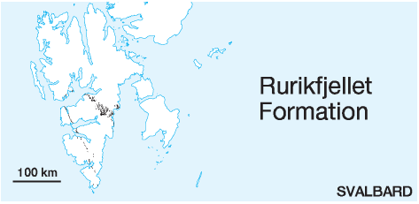 DISTRIBUTION shown on figs.: 3-06, 3-07, 3-08, 3-09, 3-10, 3-11, 3-12 (partly within 'Janusfjellet Subgroup, undifferentiated') STATUS OF UNIT: Formal FIRST USE OF NAME: Parker 1967 CURRENT DEFINITION: Parker 1967 SYNONYM(S) AND REFERENCE(S): None ORIGIN OF NAME: Rurikfjellet: A mountain in Heer Land, Agardhbukta TYPE SECTION (Figs. 3-70, 3-75): Stratotype: Agardhfjellet, eastern Sabine Land. Hypostratotype: Wimanfjellet, northern Nordenskiöld Land DEPOSITIONAL AGE: Berriasian - early Barremian DATING METHODS AND REFERENCE(S) FOR AGE: Macrofossils (e.g. ammonites): Frebold 1928; Różycki 1959; Parker 1967; Birkenmajer & Pugaczewska 1975; Pčelina 1980. Foraminifera: Nagy et al. 1988, 1990. Palynology: Løfaldli & Thusu 1976; Bjærke 1978; Grøsfjeld 1992. OVERLYING UNIT(S): Helvetiafjellet Formation UNDERLYING UNIT(S): Agardhfjellet Formation SUPERIOR UNIT: Janusfjellet Subgroup OTHER USE OF NAME: None THICKNESS: 110-400 m, 176 m in the stratotype MAIN LITHOLOGIES: Dark shale, siltstone, sandstone LOWER BOUNDARY DEFINITION: The lower boundary is defined at a sharp contact between underlying shales/siltstones and overlying shale with nodules. Where present, the boundary is defined by the base of the plastic clays of the Myklegardfjellet Bed. There is a distinct break in slope at the boundary, and exposures of the unit show different geomorphologic features – e.g. gullies that have developed in the underlying Agardhfjellet Formation do not continue up into the Rurikfjellet Formation. DESCRIPTION: The dominant lithology is dark shale with clay-ironstone and siltstone nodules, coarsening upward to siltstones and sandstones. Dypvik et al. (1991) subdivided the formation into the Wimanfjellet and Ullaberget members, the latter representing the upper coarsening-upwards part of the formation. Wimanfjellet Member (M-77) STATUS OF UNIT: Formal FIRST USE OF NAME: Dypvik et al. 1991 CURRENT DEFINITION: Dypvik et al. 1991 SYNONYM(S) AND REFERENCE(S): None ORIGIN OF NAME: Wimanfjellet: A mountain in northern Nordenskiöld Land TYPE SECTION (Fig. 3-75): Stratotype: Wimanfjellet, northern Nordenskiöld Land DEPOSITIONAL AGE: Berriasian - Valanginian DATING METHODS AND REFERENCE(S) FOR AGE: See Rurikfjellet Formation OVERLYING UNIT(S): Ullaberget Member UNDERLYING UNIT(S): Slottsmøya Member SUPERIOR UNIT: Rurikfjellet Formation OTHER USE OF NAME: None THICKNESS: 180 m in the stratotype, variable MAIN LITHOLOGIES: Shale LOWER BOUNDARY DEFINITION: The lower boundary is defined at the base of the Myklegardfjellet Bed (see there). DESCRIPTION: The Wimanfjellet Member is recognised in central and eastern Spitsbergen. Myklegardfjellet Bed (M-78) STATUS OF UNIT: Formal FIRST USE OF NAME: Birkenmajer 1980 CURRENT DEFINITION: Birkenmajer 1980 SYNONYM(S) AND REFERENCE(S): None ORIGIN OF NAME: Myklegardfjellet: A mountain in southern Sabine Land, Agardhbukta TYPE SECTION: Stratotype: Myklegardfjellet, Sabine Land DEPOSITIONAL AGE: Berriasian DATING METHODS AND REFERENCE(S) FOR AGE: See Rurikfjellet Formation UNDERLYING UNIT(S): Slottsmøya Member SUPERIOR UNIT: Wimanfjellet Member OTHER USE OF NAME: None THICKNESS: 0.5-11 m MAIN LITHOLOGIES: Mudstone LOWER BOUNDARY DEFINITION: The base is defined by the onset of reddish-yellow or green plastic clay, overlying dark shales of the Slottsmøya Member. DESCRIPTION: The Myklegardfjellet Bed is recognised throughout central and eastern Spitsbergen, including the outer Isfjorden area (Dypvik et al. 1991; J. Nagy, unpubl. data) (Fig. 3-76). The bed consists of reddish-yellow to green clays, usually very soft (plastic). Sometimes thin grey lenticular dolomite concretions with pyrite occur in the upper part. Ullaberget Member (M-79) STATUS OF UNIT: Formal FIRST USE OF NAME: Różycki 1959 CURRENT DEFINITION: Birkenmajer 1975 SYNONYM(S) AND REFERENCE(S): None ORIGIN OF NAME: Ullaberget: A mountain in Nathorst Land TYPE SECTION (Fig. 3-78): Stratotype: Ullaberget, Nathorst Land. Hypostratotype: Kikutodden, Sørkapp Land DEPOSITIONAL AGE: Valanginian - Early Barremian DATING METHODS AND REFERENCE(S) FOR AGE: See Rurikfjellet Formation OVERLYING UNIT(S): Helvetiafjellet Formation UNDERLYING UNIT(S): Wimanfjellet Member, Tirolarpasset member SUPERIOR UNIT: Rurikfjellet Formation OTHER USE OF NAME: None THICKNESS: 10-160 m, 155 m in the stratotype MAIN LITHOLOGIES: Shale, siltstone, sandstone LOWER BOUNDARY DEFINITION: The lower boundary is defined at the first appearance of sandstones above grey shales of the Wimanfjellet Member. DESCRIPTION: The Ullaberget Member is recognised in all sections of the Rurikfjellet Formation on Spitsbergen and constitutes the uppermost, generally coarsening-upward part of the Rurikfjellet Formation. The unit consists of shales, siltstones and sandstones forming a varying number of coarsening-upward minor successions developed in the upper part of the Janusfjellet Subgroup. The coarsest sandstone units occur in southern Spitsbergen where Pčelina (1983) defined the "Kikutodden Member" (Fig. 3-77). This thick, coarse-grained development is here introduced as a reference section (hypostratotype) (Edwards 1976). Back to top FUGLEN FORMATION (M-80) OCCURRENCE: Offshore unit, known from the Hammerfest Basin (Fig. 1-02) STATUS OF UNIT: Formal FIRST USE OF NAME: Worsley et al. 1988 CURRENT DEFINITION: Worsley et al. 1988 SYNONYM(S) AND REFERENCE(S): None ORIGIN OF NAME: Fuglen (transl. "The Bird"): A lighthouse on the western tip of Sørøya, northern Norway TYPE SECTION: Stratotype: Exploration well 7120/12-1. Hypostratotype: Exploration well 7119/12-1 DEPOSITIONAL AGE: Late Bathonian - middle Oxfordian DATING METHOD: Ammonites, palynology REFERENCE(S) FOR AGE: Smelror 1994, and unpubl. IKU data OVERLYING UNIT(S): Hekkingen Formation UNDERLYING UNIT(S): Stø Formation, Realgrunnen Subgroup SUPERIOR UNIT: Adventdalen Group OTHER USE OF NAME: None THICKNESS: 28 m (stratotype), 48 m (hypostratotype) MAIN LITHOLOGIES: Mudstone, limestone LOWER BOUNDARY DEFINITION: The lower boundary is marked by sharp increases in gamma ray and density responses and by an accompanying decrease in interval transit time. DESCRIPTION: The unit consists of pyritic mudstones with interbedded thin limestones which give characteristic gamma, sonic and density log responses. The mudstones are dark brown and the limestones white to brownish grey. Back to top HEKKINGEN FORMATION (M-81) OCCURRENCE: Offshore unit, known from the Hammerfest Basin and the Bjarmeland Platform (Fig. 1-02) STATUS OF UNIT: Formal FIRST USE OF NAME: Worsley et al. 1988 CURRENT DEFINITION: Worsley et al. 1988 SYNONYM(S) AND REFERENCE(S): None ORIGIN OF NAME: Hekkingen: A lighthouse on the northern tip of Senja, northern Norway TYPE SECTION: Stratotype: Exploration well 7120/12-1. Hypostratotype: Exploration well 7119/12-1 DEPOSITIONAL AGE: Late Oxfordian - Volgian DATING METHOD: Ammonites, palynology REFERENCE(S) FOR AGE: Wierzbowski & Århus 1990; Wierzbowski & Smelror 1993 and unpubl. IKU data OVERLYING UNIT(S): Knurr and Klippfisk formations UNDERLYING UNIT(S): Fuglen Formation SUPERIOR UNIT: Adventdalen Group OTHER USE OF NAME: None THICKNESS: 359 m (stratotype), 113 m (hypostratotype) MAIN LITHOLOGIES: Mudstone, limestone, shale, siltstone, sandstone LOWER BOUNDARY DEFINITION: The base is defined by the transition from carbonate-cemented, pyritic mudstone to poorly consolidated shales, producing a sudden increase in interval transit time and an abrupt decrease in bulk density values. DESCRIPTION: The Hekkingen Formation consists of brownish-grey to very dark grey shales and mudstones with occasional thin interbeds of limestone, dolomite, siltstone and sandstone. The minor clastic components are most common towards the basin margins. Alge Member (M-82) STATUS OF UNIT: Formal FIRST USE OF NAME: Worsley et al. 1988 CURRENT DEFINITION: Worsley et al. 1988 SYNONYM(S) AND REFERENCE(S): None ORIGIN OF NAME: Alge: Norwegian for 'algae' TYPE SECTION: Stratotype: Exploration well 7119/12-1. Hypostratotype: Exploration well 7120/12-1 DEPOSITIONAL AGE: Late Oxfordian - Kimmeridgian DATING METHOD: See Hekkingen Formation REFERENCE(S) FOR AGE: See Hekkingen Formation OVERLYING UNIT(S): Krill Member UNDERLYING UNIT(S): Fuglen Formation SUPERIOR UNIT: Hekkingen Formation OTHER USE OF NAME: None THICKNESS: 35 m (stratotype), 50 m (hypostratotype) MAIN LITHOLOGIES: Shale LOWER BOUNDARY DEFINITION: See Fuglen Formation DESCRIPTION: The Alge Member forms the lower high gamma intensity part of the Hekkingen Formation and consists of black paper shales rich in organic material. The member was deposited in restricted shelf environments. See also Hekkingen Formation. Krill Member (M-83) STATUS OF UNIT: Formal FIRST USE OF NAME: Worsley et al. 1988 CURRENT DEFINITION: Worsley et al. 1988 SYNONYM(S) AND REFERENCE(S): None ORIGIN OF NAME: Krill: 'Krill' in English and Norwegian is a small, marine shrimp-like crustacean, the main food source of many marine mammals and bird species. TYPE SECTION: Stratotype: Exploration well 7120/12-1. Hypostratotype: Exploration well 7119/12-1 DEPOSITIONAL AGE: Kimmeridgian-Volgian DATING METHOD: See Hekkingen Formation REFERENCE(S) FOR AGE: See Hekkingen Formation OVERLYING UNIT(S): Knurr and Klippfisk formations UNDERLYING UNIT(S): Alge Member SUPERIOR UNIT: Hekkingen Formation OTHER USE OF NAME: None THICKNESS: 80 m (stratotype), 310 m (hypostratotype) MAIN LITHOLOGIES: Mudstone, limestone, shale, siltstone, sandstone LOWER BOUNDARY DEFINITION: The base is defined at the abrupt reduction in gamma ray intensity. DESCRIPTION: The Krill Member is dominated by brownishgrey to very dark grey shale and mudstone with occasional thin interbeds of limestone, dolomite, siltstone and sandstone. The unit was deposited in open to restricted shelf environments. See also Hekkingen Formation. Back to top KNURR FORMATION (M-84) OCCURRENCE: Offshore unit, known from the Hammerfest Basin (Fig. 1-02) STATUS OF UNIT: Formal FIRST USE OF NAME: Worsley et al. 1988 CURRENT DEFINITION: Worsley et al. 1988 SYNONYM(S) AND REFERENCE(S): None ORIGIN OF NAME: Knurr: Norwegian for the fish species 'grey gurnard' (Eutrigla gurnardus) TYPE SECTION: Stratotype: Exploration well 7119/12-1. Hypostratotype: Exploration well 7120/12-1 DEPOSITIONAL AGE: (?Volgian) /Valanginian - early Barremian DATING METHOD: Dinoflagellates, foraminifera REFERENCE(S) FOR AGE: No published data available; dated by Worsley et al. (1988) on the basis of proprietary oil company data. OVERLYING UNIT(S): Kolje Formation UNDERLYING UNIT(S): Hekkingen Formation SUPERIOR UNIT: Adventdalen Group OTHER USE OF NAME: None THICKNESS: 56 m (stratotype), 285 m (hypostratotype) MAIN LITHOLOGIES: Mudstone, limestone, sandstone LOWER BOUNDARY DEFINITION: The base is defined by decreasing gamma ray response and by the sonic log showing decreasing interval transit time. In the reference well, the base is marked by a thin sandy limestone. DESCRIPTION: The Knurr Formation consists of dark grey to greyish-brown mudstone with thin limestone and dolomite interbeds in the type section. Sandstones are also seen in the lower part of the unit, but these disappear laterally into the Hammerfest Basin. Red to yellow brown mudstones generally occur in the upper part of the formation. Back to top KLIPPFISK FORMATION (M-85) OCCURRENCE: Offshore unit, known from the Bjarmeland Platform (Fig. 1-02) and Kong Karls Land (Fig. 3-11) STATUS OF UNIT: Formal FIRST USE OF NAME: Smelror et al. 1998 CURRENT DEFINITION: Smelror et al. 1998 SYNONYM(S) AND REFERENCE(S): None ORIGIN OF NAME: Klippfisk: Norwegian for 'stockfish, dried cod' TYPE SECTION: Stratotype: Exploration well 7430/10-U-01. Hypostratotype: Exploration well 7231/01-U-01 DEPOSITIONAL AGE: Late Berriasian - Hauterivian DATING METHOD: Palynology, nannofossils, bivalves REFERENCE(S) FOR AGE: Århus et al. 1990; Smelror et al. 1998 OVERLYING UNIT(S): Kolje Formation UNDERLYING UNIT(S): Hekkingen Formation SUPERIOR UNIT: Adventdalen Group OTHER USE OF NAME: None THICKNESS: 8.9 m (stratotype), 4.5 m (hypostratotype), 15 m in Kong Karls Land MAIN LITHOLOGIES: Limestone, marl, calcareous sandstone LOWER BOUNDARY DEFINITION: The base is defined at the abrupt decrease in gamma ray intensity, where the dark mudstones of the underlying formation are replaced by marls. DESCRIPTION: The Klippfisk Formation represents a condensed carbonate succession occurring in platform areas (Kutling Member), where it consists of limestones and marls, and is often glauconitic. The limestones may have a nodular appearance. Fossil debris, dominated by Inoceramus prisms may be abundant. The formation is strongly bioturbated. Kutling Member (M-86) STATUS OF UNIT: Formal FIRST USE OF NAME: Smelror et al. 1998 CURRENT DEFINITION: Smelror et al. 1998 SYNONYM(S) AND REFERENCE(S): None ORIGIN OF NAME: Kutling: Norwegian for the fish family 'goby' (Gobiidae) TYPE SECTION: Stratotype: Exploration well 7430/10-U-01. Hypostratotype: Exploration well 7231/01-U-01 DEPOSITIONAL AGE: Late Berriasian - Hauterivian DATING METHOD: Palynology, nannofossils, bivalves REFERENCE(S) FOR AGE: Århus et al. 1990; Smelror et al. 1998 OVERLYING UNIT(S): Kolje Formation UNDERLYING UNIT(S): Hekkingen Formation SUPERIOR UNIT: Klippfisk Formation OTHER USE OF NAME: None THICKNESS: 8.9 m (stratotype), 4.5 m (hypostratotype) MAIN LITHOLOGIES: Limestone, marl LOWER BOUNDARY DEFINITION: See Klippfisk Formation DESCRIPTION: The Kutling Member is a condensed carbonate succession and represents the entire Klippfisk Formation on the Bjarmeland Platform. See also Klippfisk Formation. Tordenskjoldberget Member (M-87) 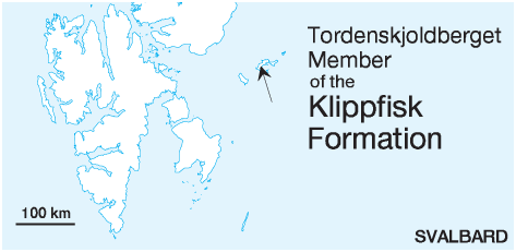 STATUS OF UNIT: Formal FIRST USE OF NAME: Smith et al. 1976 CURRENT DEFINITION: Here SYNONYM(S) AND REFERENCE(S): The "Tordenskjoldberget Limestone Member" (Smith et al. 1976) includes 15 m of overlying shale which is now included in the Kolje Formation (Smelror et al. 1998). ORIGIN OF NAME: Tordenskjoldberget: A mountain on Kongsøya, Kong Karls Land TYPE SECTION: Stratotype: Tordenskjoldberget DEPOSITIONAL AGE: Late Berriasian - Hauterivian DATING METHOD: Palynology, nannofossils REFERENCE(S) FOR AGE: Bjærke 1977; Verdenius 1978; Smelror et al. 1998 OVERLYING UNIT(S): Kolje Formation UNDERLYING UNIT(S): Høgsletta Member, Agardhfjellet Formation SUPERIOR UNIT: Klippfisk Formation OTHER USE OF NAME: None THICKNESS: 15 m in the stratotype MAIN LITHOLOGIES: Calcareous sandstone, limestone LOWER BOUNDARY DEFINITION: The lower boundary is covered in the entire exposure area. DESCRIPTION: The Tordenskjoldberget Member is a limestone unit representing the entire Klippfisk Formation on Kong Karls Land. It has been found only along one mountain side of Tordenskjoldberget for a distance of little more than 1 km. Back to top KOLJE FORMATION (M-88) 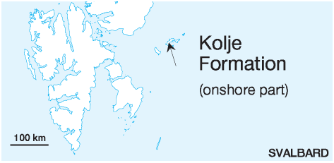 OCCURRENCE: Offshore unit, known from the Hammerfest Basin (Fig. 1-02, Fig. 3-11) STATUS OF UNIT: Formal FIRST USE OF NAME: Worsley et al. 1988 CURRENT DEFINITION: Worsley et al. 1988 SYNONYM(S) AND REFERENCE(S): None ORIGIN OF NAME: Kolje: Norwegian for 'haddock' (Melanogrammus aeglefinus) TYPE SECTION: Stratotype: Exploration well 7119/12-1. Hypostratotype: Exploration well 7120/12-1 DEPOSITIONAL AGE: Barremian - ?early Aptian DATING METHOD: Palynology REFERENCE(S) FOR AGE: No published data available; dated by Worsley et al. (1988) on the basis of proprietary oil company data. OVERLYING UNIT(S): Kolmule Formation UNDERLYING UNIT(S): Knurr and Klippfisk formations SUPERIOR UNIT: Adventdalen Group OTHER USE OF NAME: None THICKNESS: 437 m (stratotype), 103 m (hypostratotype), 15 m in Kong Karls Land MAIN LITHOLOGIES: Shale, mudstone, limestone, dolomite LOWER BOUNDARY DEFINITION: The base is marked by gradually decreasing gamma ray, decreasing interval transit time and increasing density log responses in the type well. However, in central parts of the Hammerfest Basin, the density log response shows a decreasing trend at the base. DESCRIPTION: The Kolje Formation consists of dark brown to grey shale and mudstone, with minor interbeds of pale limestone and dolomite. The upper part of the formation also has thin interbeds of light grey-brown siltstone and sandstone. Back to top HELVETIAFJELLET FORMATION (M-89) 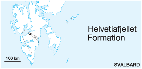 DISTRIBUTION shown on figs.: 3-06, 3-07, 3-08, 3-09, 3-10, 3-11 STATUS OF UNIT: Formal FIRST USE OF NAME: Parker 1967 CURRENT DEFINITION: Parker 1967 SYNONYM(S) AND REFERENCE(S): "Sandsteinreihe": Nathorst 1910; "Continental Series": Różycki 1959; "Shore sandstone": Hagerman 1925. ORIGIN OF NAME: Helvetiafjellet: A mountain in eastern Nordenskiöld Land TYPE SECTION (Fig. 3-82): Stratotype: Helvetiafjellet, eastern Nordenskiöld Land DEPOSITIONAL AGE: Barremian DATING METHOD: Plant fossils; indirect, stratigraphic relationships REFERENCE(S) FOR AGE: Parker 1967; Vasilevskaja 1980 OVERLYING UNIT(S): Carolinefjellet Formation UNDERLYING UNIT(S): Rurikfjellet, Agardhfjellet and Kolje formations SUPERIOR UNIT: Adventdalen Group OTHER USE OF NAME: None THICKNESS: 40-155 m (measured sections, no geographical trend), probably thicker at Keilhaufjellet (Sørkapp Land); 45 m in the stratotype MAIN LITHOLOGIES: Sandstone, shale, coal, conglomerate LOWER BOUNDARY DEFINITION: The lower boundary is defined as the erosional base of a massive, fluvio-deltaic sandstone on top of the marine coarsening-upward successions of the Ullaberget Member or the shales and mudstones of the Kolje Formation. DESCRIPTION: The Helvetiafjellet Formation consists of coarse sandstones with subordinate carbonaceous shales and thin coal seams. The basal part of varying thickness is made up of the massive Festningen sandstone member, which actually consists of several laterally interfingering lobes, with interbedded siltstones, shales and local coals (Figs. 3-79, 3-80). The upper part of the formation consists of coarse, grey sandstones, cross-bedded and ripple-laminated, with abundant plant remains and carbonaceous streaks, together with carbonaceous shales, clay-ironstone horizons and thin seams of coal. Material of volcanic origin is present in several thin beds. Dinosaur footprints are found at several places (Fig. 3-81). The Helvetiafjellet Formation is interpreted as the result of interacting fluvial, delta plain, mouth-bar, barrier-bar, tidal estuary and transgressive sheet sandstone facies formed after a period of relative fall in sea level followed by sea level rise and transgression (Gjelberg & Steel 1995). Festningen (sandstone) member (M-90) STATUS OF UNIT: Informal FIRST USE OF NAME: Nathorst 1910 CURRENT DEFINITION: Parker 1967 SYNONYM(S) AND REFERENCE(S): None ORIGIN OF NAME: Festningen (transl. "The Fort"): A skerry off the southern coast of outer Isfjorden consisting of this unit. TYPE SECTION (Fig. 3-84): Stratotype: Festningen, outer Isfjorden DEPOSITIONAL AGE: Barremian DATING METHOD: Indirect, stratigraphic relationships REFERENCE(S) FOR AGE: Parker 1967 OVERLYING UNIT(S): Unnamed UNDERLYING UNIT(S): Rurikfjellet Formation SUPERIOR UNIT: Helvetiafjellet Formation OTHER USE OF NAME: The 'Festningen' skerry has given its name to a large stratigraphic reference section through the Upper Palaeozoic and entire Mesozoic, the Festningen section. THICKNESS: Metres to a few tens of metres, not defined in many places; 15.5 m in the stratotype MAIN LITHOLOGIES: Sandstone, conglomerate LOWER BOUNDARY DEFINITION: See Helvetiafjellet Formation. DESCRIPTION: The Festningen sandstone member is wellestablished and a useful descriptive name, but kept informal. The reason is that a clear definition and delimitation against other parts of the Helvetiafjellet Formation is impossible. The unit represents prominent, cliff-forming, hard, light grey sandstones in the lower part of the Helvetiafjellet Formation. It weathers grey, but also yellowish and orange, with variable grain size, normally from medium-grained sandstone to a coarse conglomerate. Cross-bedding is typical and conglomeratic beds and lenses occur frequently. As shown by Steel (1977) and Gjelberg & Steel (1995), the Festningen sandstone member consists of several interfingering sandstone lobes. The facies is interpreted as mainly fluvial, although interacting with fluvial-dominated mouth bar and interdistributary bay environments. Hårfagrehaugen Member (M-91) STATUS OF UNIT: Formal FIRST USE OF NAME: Smith et al. 1976 CURRENT DEFINITION: Here, Olaussen et al., in prep. SYNONYM(S) AND REFERENCE(S): "Hårfagrehaugen Sandstone Member" (Smith et al. 1976): Only applied to western Kongsøya; "Johnsenberget Sandstone Member" (Smith et al. 1976): Correlative of the Hårfagrehaugen Member, but only applied to eastern Kongsøya; "Kükenthalfjellet Sandstone Member" (Smith et al. 1976): Correlative of the Hårfagrehaugen Member, but only applied to Svenskøya. ORIGIN OF NAME: Hårfagrehaugen: A mountain on Kongsøya, Kong Karls Land TYPE SECTION (Figs. 3-87, 3-88, 3-89): Boundary stratotype: Hårfagrehaugen, Kongsøya. Unit Stratotype: Sjøgrenfjellet W, Kongsøya. Hypostratotype: Kükenthalfjellet, Svenskøya DEPOSITIONAL AGE: Barremian DATING METHOD: Indirect, stratigraphic relationships REFERENCE(S) FOR AGE: Smith et al. 1976; Bjærke 1977 OVERLYING UNIT(S): Kong Karls Land Flows UNDERLYING UNIT(S): Agardhfjellet and Kolje formations SUPERIOR UNIT: Helvetiafjellet Formation OTHER USE OF NAME: None THICKNESS: Up to 70 m, including intercalated lava flows MAIN LITHOLOGIES: Sandstone, conglomerate, mudstone LOWER BOUNDARY DEFINITION: See Helvetiafjellet Formation DESCRIPTION: The Hårfagrehaugen Member represents the Helvetiafjellet Formation in Kong Karls Land. The member rests with a probable erosional boundary on top of the Agardhfjellet Formation and, locally, the Kolje Formation. The unit consists of sedimentary rocks dominated by sandstones in the lower part (Fig. 3-85), and by interbedded coal (<1m), mudstones and sandstones in the upper part. Silicified wood occurs abundantly (Fig. 3-86). On Kongsøya the member shows a twofold appearance by colour. The lower part consists of yellow and white sandstones and conglomerates with quartzitic pebbles, mudstones and coal clasts. Separated by a sharp boundary, the upper part contains green sandstones with volcanoclastic and quartzitic pebbles, mudstones and coal-fragments. This boundary represents the onset of volcanic activity. The member was mainly deposited in fluvial channels, probably braided streams, in incised valleys/creeks and passes upwards into flood plain/delta plain deposits. Kong Karls Land Flows (M-92) STATUS OF UNIT: Formal FIRST USE OF NAME: Smith et al. 1976 CURRENT DEFINITION: Here, Olaussen et al., in prep. SYNONYM(S) AND REFERENCE(S): "Kong Karls Land Formation" (Smith et al. 1976): Synonym of Helvetiafjellet Formation in Kong Karls Land. The stratigraphy of Kong Karls Land has been substantially revised according to recent understanding (see chapters 3.4.2, 3.6.1). ORIGIN OF NAME: Kong Karls Land: A small archipelago in the eastern reaches of the Svalbard island group TYPE SECTION (Fig. 3-91): Stratotype: Sjøgrenfjellet S, Kongsøya DEPOSITIONAL AGE: Barremian and ?Aptian DATING METHOD: Indirect, stratigraphic relationships REFERENCE(S) FOR AGE: Smith et al. 1976 OVERLYING UNIT(S): None UNDERLYING UNIT(S): Hårfagrehaugen Member SUPERIOR UNIT: Helvetiafjellet Formation OTHER USE OF NAME: Kong Karls Land Platform ("Kong Karl platform" of Gabrielsen et al. 1990): A structural element on the northern Barents Shelf, on which the archipelago of Kong Karls Land is situated THICKNESS: Up to 25 m, top eroded MAIN LITHOLOGIES: Basalt DESCRIPTION: The Kong Karls Land Flows represent two basaltic lava flows and associated pyroclastic rocks which interfinger with the sediments of the Hårfagrehaugen Member. The lower basalt flow varies considerably in thickness, and is locally overlain by grey-green pyroclastic rocks with large lava fragments. The upper basalt flow rests on sandstones and shales of the Hårfagrehaugen Member and varies little in thickness. Unfortunately, none of the logged sections reach up to the second flow or the intervening pyroclastics. The basalts have a varying appearance, but all are microporphyritic. They contain minor amounts of weathered glass and variable amounts of vesicles and larger cavities which may be filled by quartz (amethyst), calcite or other minerals. The basalts may show columnar jointing (Fig. 3-90). The flows may be difficult to distinguish from sills and dikes which are present at a similar stratigraphic level at Kükenthalfjellet on Svenskøya. The basalts are classified as andesites. Back to top CAROLINEFJELLET FORMATION (M-93)  DISTRIBUTION shown on figs.: 3-06, 3-07, 3-08, 3-09, 3-10 STATUS OF UNIT: Formal FIRST USE OF NAME: Parker 1967 CURRENT DEFINITION: Nagy 1970 SYNONYM(S) AND REFERENCE(S): "Dentalienschichten": Nathorst 1910; "Ditrupa Shale Series": Różycki 1959 ORIGIN OF NAME: Carolinefjellet: A mountain in northern Nordenskiöld Land TYPE SECTION (Fig. 3-93): Stratotype: Langstakken, eastern Nordenskiöld Land DEPOSITIONAL AGE: Aptian - Albian DATING METHODS AND REFERENCE(S) FOR AGE: Macrofossils: Parker 1967; Pčelina 1967; Nagy 1970. Dinoflagellates: Thusu 1978; Århus 1991 OVERLYING UNIT(S): Firkanten Formation UNDERLYING UNIT(S): Helvetiafjellet Formation SUPERIOR UNIT: Adventdalen Group OTHER USE OF NAME: None THICKNESS: 190-?1200 m; increasing to the southeast; 770 m in the stratotype MAIN LITHOLOGIES: Shale, siltstone, sandstone LOWER BOUNDARY DEFINITION: Both under- and overlying successions show shale-sandstone alternations of metre to 10 m scale, which in many places constitute coarsening-upward units. The lower boundary of the Carolinefjellet Formation is defined at the bottom of the first coarsening-upward unit or shale-sandstone pair which ends up with the typical, greenishweathering sandstones of the Dalkjegla Member. DESCRIPTION: The Carolinefjellet Formation is subdivided into five members according to the predominance of sandstones or shales. In most areas with outcrops of the formation, three members are defined: Dalkjegla Member (sandstone-dominated), Innkjegla Member (shale-dominated), Langstakken Member (sandstone-dominated alternation of sandstones and shales) (Fig. 3-94). In the southern parts of Spitsbergen the Zillerberget member occurs consisting of shales and siltstones. The uppermost Schönrockfjellet member, again of alternating shales and sandstones (dominated by the latter) occurs very locally on southeastern Spitsbergen. (Fig. 3-92) The formation was deposited in prodelta to distal marine shelf conditions following the fluvial and delta-related facies of the underlying Helvetiafjellet Formation. It correlates with the Kolmule Formation of the Barents Shelf. Dalkjegla Member (M-94) STATUS OF UNIT: Formal FIRST USE OF NAME: Parker 1967 CURRENT DEFINITION: Parker 1967 SYNONYM(S) AND REFERENCE(S): "Dalkjegla Formation": Pčelina 1983; "Lower lamina sandstone": Hagerman 1925 ORIGIN OF NAME: Dalkjegla (transl. "The Valley Cone"): A mountain in eastern Nordenskiöld Land TYPE SECTION (Fig. 3-93): Stratotype: Langstakken, eastern Nordenskiöld Land DEPOSITIONAL AGE: Aptian DATING METHODS AND REFERENCE(S) FOR AGE: Macrofossils: Parker 1967; Pčelina 1967. Dinoflagellates: Århus 1991 OVERLYING UNIT(S): Innkjegla Member UNDERLYING UNIT(S): Helvetiafjellet Formation SUPERIOR UNIT: Carolinefjellet Formation OTHER USE OF NAME: None THICKNESS: Ca. 50-180 m, thickening southeastwards; 130 m in the stratotype MAIN LITHOLOGIES: Sandstone, shale LOWER BOUNDARY DEFINITION: See Carolinefjellet Formation DESCRIPTION: The Dalkjegla Member is a cliff-forming unit. It consists of fine- to medium-grained, flaggy, thinbedded, greenish-grey sandstones with intercalated grey siltstones and shales. The sandstones may contain minor amounts of carbonate. Mud flakes, cross-bedding, ripple lamination, ripple marks (in great variety) and load casts occur, though undisturbed parallel laminations dominate. Bivalve shells and imprints, and Ditrupa tubes are common. Yellow, carbonate-bearing sand interbeds of a few cm to dm thickness, locally with gravel, show hummocky cross-stratification and may be storm deposits. The member was deposited in shallow marine prodelta environments. Innkjegla Member (M-95) STATUS OF UNIT: Formal FIRST USE OF NAME: Parker 1967 CURRENT DEFINITION: Parker 1967 SYNONYM(S) AND REFERENCE(S): "Singerfjella Formation" in eastern and southern Spitsbergen: Pčelina 1983; "Ymerbukta Formation" in western Spitsbergen: Pčelina 1983; "Cretaceous shale": Hagerman 1925 ORIGIN OF NAME: Innkjegla (transl. "The Inner Cone"): A mountain in eastern Nordenskiöld Land TYPE SECTION (Fig. 3-93): Stratotype: Langstakken, eastern Nordenskiöld Land DEPOSITIONAL AGE: Aptian - Albian DATING METHODS AND REFERENCE(S) FOR AGE: Macrofossils: Parker 1967; Pčelina 1967; Nagy 1970. Dinoflagellates: Århus 1991 OVERLYING UNIT(S): Langstakken Member, Firkanten Formation UNDERLYING UNIT(S): Dalkjegla Member SUPERIOR UNIT: Carolinefjellet Formation OTHER USE OF NAME: None THICKNESS: Ca. 160-?800 m, southeastward increasing; 430 m in the stratotype MAIN LITHOLOGIES: Shale, siltstone, sandstone LOWER BOUNDARY DEFINITION: The lower boundary is defined by the sudden predominance of monotonous, grey to dark-grey shales above the sandstone-dominated Dalkjegla Member. DESCRIPTION: The Innkjegla Member is a succession of grey shales, weathering grey, with interbeds of yellow weathering grey siltstone in the lower part and with intercalations of grey, flaggy, fine- to medium-grained sandstone, weathering orange and buff. Langstakken Member (M-96) STATUS OF UNIT: Formal FIRST USE OF NAME: Parker 1967 CURRENT DEFINITION: Parker 1967 SYNONYM(S) AND REFERENCE(S): Lower part of "Kvalvågen Formation": Pčelina 1983; Lower part of "Upper lamina sandstone": Hagerman 1925 ORIGIN OF NAME: Langstakken (transl. "The Long Skirt", possibly "long stack"): A mountain in eastern Nordenskiöld Land TYPE SECTION (Fig. 3-93): Stratotype: Langstakken, eastern Nordenskiöld Land DEPOSITIONAL AGE: Albian DATING METHODS AND REFERENCE(S) FOR AGE: Macrofossils: Parker 1967; Pčelina 1967; Nagy 1970. Dinoflagellates: Århus 1991 OVERLYING UNIT(S): Zillerberget member and Firkanten Formation UNDERLYING UNIT(S): Innkjegla Member SUPERIOR UNIT: Carolinefjellet Formation OTHER USE OF NAME: None THICKNESS: 208 m in the stratotype MAIN LITHOLOGIES: Sandstone, siltstone, shale LOWER BOUNDARY DEFINITION: The lower boundary is defined at the onset of equal sandstone – shale alternations above the shale-dominated Innkjegla Member. DESCRIPTION: The Langstakken Member consists of alternating shales, siltstones and flaggy, thin-bedded grey sandstones, weathering grey-green (Fig. 3-94). Both the lower and upper boundaries are transitional. At the base of the unit in the type section, there is an equal alternation of shales and sandstones in units about 10-15 m thick, although higher up in the succession sandstones predominate, and ripple marks are common. The fossil content is similar to that of the Innkjegla Member, but is more scarce. The member was deposited in moderately deep marine shelf environments. Zillerberget member (M-97) STATUS OF UNIT: Informal FIRST USE OF NAME: Nagy 1970 CURRENT DEFINITION: Nagy 1970 SYNONYM(S) AND REFERENCE(S): Middle part of "Kvalvågen Formation": Pčelina 1983; Middle part of "Upper lamina sandstone": Hagerman 1925 ORIGIN OF NAME: Zillerberget: A mountain in northeastern Wedel Jarlsberg Land TYPE SECTION (Fig. 3-97): Stratotype: Zillerberget, northeastern Wedel Jarlsberg Land. Hypostratotype: Schönrockfjellet, eastern Torell Land DEPOSITIONAL AGE: Albian DATING METHOD: Ammonites REFERENCE(S) FOR AGE: Nagy 1970 OVERLYING UNIT(S): Schönrockfjellet member and Firkanten Formation UNDERLYING UNIT(S): Langstakken Member SUPERIOR UNIT: Carolinefjellet Formation OTHER USE OF NAME: None THICKNESS: Up to 334 m (Heer Land) MAIN LITHOLOGIES: Sandstone, siltstone, shale LOWER BOUNDARY DEFINITION: The lower boundary is not sufficiently defined, but is in general characterised by the onset of alternating clastic lithologies above the sandstone-dominated Langstakken Member. The uppermost shaleprone part assigned to the Langstakken Member in Fig. 3-93 may belong to the Zillerberget Member, but this member was not recognised as an individual unit by Parker (1967). DESCRIPTION: The Zillerberget member consists of grey shales and siltstones with beds of grey-green, fine-grained sandstone (Fig. 3-96). The sandstones occur in more or less laterally persistent beds (5-20 cm thick) interbedded with the finer-grained sediment. The member was deposited in moderately deep marine shelf environments. Both the lower and upper boundaries of the member are transitional. The member, as defined and illustrated by Nagy (1970), was not accompanied by a type section log. Later work in southern Spitsbergen has shown difficulties in recognising member boundaries above the Langstakken Member, and the unit should be regarded as informal until further investigations have been carried out. Schönrockfjellet member (M-98) STATUS OF UNIT: Informal FIRST USE OF NAME: Nagy 1970 CURRENT DEFINITION: Nagy 1970 SYNONYM(S) AND REFERENCE(S): Upper part of "Kvalvågen Formation": Pčelina 1983; Upper part of "Upper lamina sandstone": Hagerman 1925 ORIGIN OF NAME: Schönrockfjellet: A mountain in Heer Land TYPE SECTION (Fig. 3-97): Stratotype: Schönrockfjellet, eastern Torell Land. Hypostratotype: Schönrockfjellet, eastern Torell Land. The hypostratotype is defined because the originally described section (Nagy 1970) was not accompanied by a log. The logged section is not located in the same place. DEPOSITIONAL AGE: Albian DATING METHOD: Ammonites REFERENCE(S) FOR AGE: Nagy 1970 OVERLYING UNIT(S): Firkanten Formation UNDERLYING UNIT(S): Zillerberget member SUPERIOR UNIT: Carolinefjellet Formation OTHER USE OF NAME: None THICKNESS: 83 m in the stratotype MAIN LITHOLOGIES: Sandstone, siltstone, shale LOWER BOUNDARY DEFINITION: The lower boundary is defined where sandstones start to dominate above the shaledominated Zillerberget member. It is not recognised in the hypostratotype. DESCRIPTION: The Schönrockfjellet member is locally preserved in Heer Land. It consists of grey-green, fine-grained sandstones interbedded with dark grey shales and siltstones (Fig. 3-96). The lower boundary of the member is transitional. Sandstones dominate and usually show a distinct stratification, expressed by weathering into thin flakes by splitting along shale partings. The member was deposited in moderately deep marine shelf environments. Back to top KOLMULE FORMATION (M-99) OCCURRENCE: Offshore unit, known from the Hammerfest Basin (Fig. 1-02) STATUS OF UNIT: Formal FIRST USE OF NAME: Worsley et al. 1988 CURRENT DEFINITION: Worsley et al. 1988 SYNONYM(S) AND REFERENCE(S): None ORIGIN OF NAME: Kolmule: Norwegian for the fish species 'blue whiting' (Micromesistius poutassou) TYPE SECTION: Stratotype: Exploration well 7119/12-1. Hypostratotype: Exploration well 7120/12-1 DEPOSITIONAL AGE: Aptian - Middle Cenomanian DATING METHOD: Palynology REFERENCE(S) FOR AGE: No published data available; dated by Worsley et al. (1988) on the basis of proprietary oil company data. OVERLYING UNIT(S): Nygrunnen Group UNDERLYING UNIT(S): Kolje Formation SUPERIOR UNIT: Adventdalen Group OTHER USE OF NAME: None THICKNESS: 945 m (stratotype), 530 m (hypostratotype), thickens westwards towards and into the Tromsø Basin and slightly eastwards in the Hammerfest Basin MAIN LITHOLOGIES: Shale, mudstone, siltstone LOWER BOUNDARY DEFINITION: The base is defined by sharply increasing interval transit time and neutron porosity values and a slight decrease in gamma log response. The reference well shows a similar sonic and neutron log trend, although with a gradually increasing gamma ray log response. DESCRIPTION: The Kolmule Formation consists of darkgrey to green mudstone and shale, partly with minor thin siltstone interbeds and limestone and dolomite stringers. Traces of glauconite and pyrite occur. Back to top |
